Westport, Connecticut
| Westport | |
| CDP | |
 Lägeskarta | |
| Land |  USA USA |
|---|---|
| Delstat | Connecticut |
| County | Fairfield County |
| Koordinater | 41°7′19″N 73°20′36″V / 41.12194°N 73.34333°V / 41.12194; -73.34333 |
| Yta | 86,6 km² (2010)[1] |
| - land | 51,7 km² |
| - vatten | 35 km² |
| Folkmängd | 26 391 (2010)[2] |
| Befolkningstäthet | 510 invånare/km² |
| Tidszon | EST (UTC-5) |
| - sommartid | EDT (UTC-4) |
| ZIP-kod | 06880[3] |
| FIPS | 0983570 |
| Geonames | 4845585 |
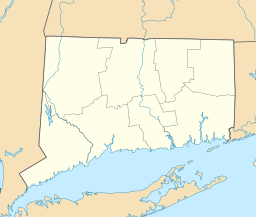  Ortens läge i Connecticut | |
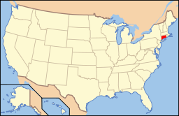 Connecticuts läge i USA | |
Westport, kommun (town) i Fairfield County, Connecticut, USA med cirka 25 749 invånare (2000).
Källor
- ^ ”2010 Census Gazetteer Files”. US Census Bureau. Arkiverad från originalet den 14 juli 2012. https://www.webcitation.org/699nOulzi?url=http://www.census.gov/geo/www/gazetteer/files/Gaz_places_national.txt. Läst 14 juli 2012.
- ^ ”Westport CDP, Connecticut” (på engelska). State & County Quickfacts. U.S. Census Bureau,. Arkiverad från originalet den 25 juni 2012. https://www.webcitation.org/68giYYoc7?url=http://quickfacts.census.gov/qfd/states/09/0983570.html. Läst 25 juni 2012.
- ^ ”2010 ZIP Code Tabulation Area (ZCTA) Relationship Files”. U.S. Census Bureau. 24 maj 2010. Arkiverad från originalet den 25 augusti 2012. https://www.webcitation.org/6ABdwXxbq?url=http://www.census.gov/geo/www/2010census/zcta_rel/zcta_place_rel_10.txt. Läst 25 augusti 2012.
| ||||||||||


