South Bucks
Niet-metropolitaans district in Engeland  | |||
|---|---|---|---|
  | |||
| Situering | |||
| Land | Engeland | ||
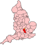
| County | Buckinghamshire | ||
| Regio | South East England | ||
| Coördinaten | 51°34'35"NB, 0°38'20"WL | ||
| Algemeen | |||
| Oppervlakte | 141,2755[1] km² | ||
| Inwoners (2018[2]) | 70.043 (496 inw./km²) | ||
| ONS-code | E07000006 | ||
| |||

South Bucks is een Engels district in het shire-graafschap (non-metropolitan county OF county) Buckinghamshire en telt 70.000 inwoners. De oppervlakte bedraagt 141 km².
Van de bevolking is 17,5% ouder dan 65 jaar. De werkloosheid bedraagt 1,9% van de beroepsbevolking (cijfers volkstelling 2001).
Civil parishes in district South Bucks
Beaconsfield, Burnham, Denham, Dorney, Farnham Royal, Fulmer, Gerrards Cross, Hedgerley, Iver, Stoke Poges, Taplow, Wexham.
Bronnen, noten en/of referenties
|


