Chiry-Ourscamp
Gemeente in Frankrijk  | |||
|---|---|---|---|
 | |||
  | |||
| Situering | |||
| Regio | Hauts-de-France | ||
| Departement | Oise (60) | ||
| Arrondissement | Compiègne | ||
| Kanton | Thourotte | ||
| Coördinaten | 49° 33' NB, 2° 57' OL | ||
| Algemeen | |||
| Oppervlakte | 13,25 km² | ||
| Inwoners (1 januari 2021) | 1.143[1] (86 inw./km²) | ||
| Hoogte | 33 - 150 m | ||
| Overig | |||
| INSEE-code | 60150 | ||
| Foto's | |||
 | |||
| Abbaye Notre-Dame | |||
| |||

Chiry-Ourscamp is een gemeente in het Franse departement Oise (regio Hauts-de-France). De plaats maakt deel uit van het arrondissement Compiègne. Chiry-Ourscamp telde op 1 januari 2021 1.143[1] inwoners.
Geografie
De oppervlakte van Chiry-Ourscamp bedroeg op 1 januari 2021 13,25 vierkante kilometer; de bevolkingsdichtheid was toen 86,3 inwoners per km².

Demografie
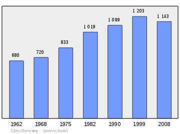
Onderstaande figuur toont het verloop van het inwonertal (bron: INSEE-tellingen).
Bronnen, noten en/of referenties
- ↑ a b Populations légales 2021.
Mediabestanden
Zie de categorie Chiry-Ourscamp van Wikimedia Commons voor mediabestanden over dit onderwerp.


