County Santa Clara, California
Santa Clara County, California | ||||||||
|---|---|---|---|---|---|---|---|---|
County | ||||||||
| County of Santa Clara | ||||||||
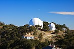
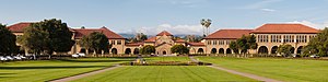
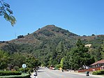
Foto, dari atas ke bawah, kiri ke kanan: Pemandangan ke barat melintasi Silicon Valley, Lick Observatory, Winchester Mystery House, pemandangan Stanford University dari seberang Oval, El Toro Hill di Morgan Hill, pemandangan udara Hangar One di Moffett Federal Airfield tahun 2012 | ||||||||
 Bendera  Lambang | ||||||||
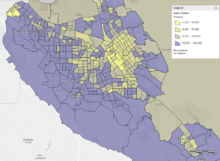
 Lokasi di negara bagian California | ||||||||
| Negara |  United States of America United States of America | |||||||
| Negara bagian |  California California | |||||||
| Region | Wilayah Teluk San Francisco | |||||||
| Incorporated | 18 Februari 1850[1] | |||||||
| Dinamai berdasarkan | Mission Santa Clara de Asís, St. Clare of Assisi | |||||||
| Ibu kota county | San Jose | |||||||
| Kota terbesar | San Jose | |||||||
| Luas | ||||||||
| • Total | 1.304 sq mi (3,380 km2) | |||||||
| • Luas daratan | 1.290 sq mi (3,300 km2) | |||||||
| • Luas perairan | 14 sq mi (40 km2) | |||||||
| Ketinggian tertinggi | 4.216 ft (1,285 m) | |||||||
| Populasi (1 April 2010)[3] | ||||||||
| • Total | 1.781.642 | |||||||
| • Perkiraan (2015)[3] | 1.918.044 | |||||||
| • Kepadatan | 1,400/sq mi (530/km2) | |||||||
| Zona waktu | UTC-8 (Pacific) | |||||||
| • Musim panas (DST) | UTC-7 (Pacific Daylight Time) | |||||||
| Kode area telepon | 408/669, 650 | |||||||
| FIPS code | 06-085 | |||||||
| GNIS feature ID | 277307 | |||||||
| Situs web | www | |||||||


Santa Clara County, California, secara resmi: County of Santa Clara, adalah sebuah county yang terletak di negara bagian California, Amerika Serikat. Menurut sensus 2010, jumlah penduduknya 1,781,642.[3] Ibu kota county ini terletak di San Jose,[4] termasuk kota berpenduduk terbanyak perinkat ke-10 di Amerika Serikat.
Santa Clara County meliputi San Jose-Sunnyvale-Santa Clara, CA Metropolitan Statistical Area juga termasuk ke dalam San Jose-San Francisco-Oakland, CA Combined Statistical Area. Terletak di ujung selatan Wilayah Teluk San Francisco, daerah berpenduduk padat di Santa Clara Valley di dalam wilayah Santa Clara County juga dikenal sebagai Silicon Valley. Santa Clara merupakan county berpenduduk terbanyak dalam Wilayah Teluk San Francisco, serta salah satu county berpendapatan tertinggi di Amerika Serikat.
Etimologi
Santa Clara County dinamai menurut Mission Santa Clara, yang didirikan pada tahun 1777, dan juga dinamai menurut tokoh perempuan, Saint Clare of Assisi.
Geografi
Menurut U.S. Census Bureau, Santa Clara county mempunyai luas wilayah 1.304 mil persegi (3.380 km2), di antaranya 1.290 mil persegi (3.300 km2) berupa tanah dan 14 mil persegi (36 km2) (1.1%) adalah perairan.[5]
San Andreas Fault membujur di sepanjang Santa Cruz Mountains pada bagian selatan dan barat county ini.
Wilayah terlindung nasional
- Don Edwards San Francisco Bay National Wildlife Refuge (sebagian)
Demografi
2011-2014
Sampai tahun 2013, Santa Clara County mempunyai median pendapatan per rumah tanggal tertinggi dari semua county di California dengan jumlah $84,741.[6]
| Penduduk, ras dan pendapatan | |||||
|---|---|---|---|---|---|
| Total population[7] | 1,762,754 | ||||
| Kulit putih[7] | 896,937 | 50.9% | |||
| Kulit hitam[7] | 45,219 | 2.6% | |||
| American Indian atau Alaska Native[7] | 9,906 | 0.6% | |||
| Asia[7] | 560,362 | 31.8% | |||
| Native Hawaiian atau other Pacific Islander[7] | 6,445 | 0.4% | |||
| Ras lain[7] | 171,082 | 9.7% | |||
| Dua ras atau lebih[7] | 72,803 | 4.1% | |||
| Hispanik atau Latino (segala ras)[8] | 468,262 | 26.6% | |||
| Pendapatan per kapita[9] | $40,698 | ||||
| Median pendapatan per rumah tangga[10] | $89,064 | ||||
| Median pendapatan per keluarga[11] | $103,255 | ||||
| Tempat menurut jumlah penduduk dan ras | ||||||||
|---|---|---|---|---|---|---|---|---|
| Tempat | Jenis[12] | Penduduk[7] | Kulit putih[7] | Lain-lain[7] [note 1] | Asian[7] | Kulit hitam American[7] | Native American[7] [note 2] | Hispanik atau Latino (segala ras)[8] |
| Alum Rock | CDP | 11,814 | 60.5% | 25.7% | 11.3% | 2.0% | 0.5% | 73.0% |
| Burbank | CDP | 5,827 | 67.3% | 19.2% | 11.6% | 1.5% | 0.3% | 48.5% |
| Cambrian Park | CDP | 3,581 | 78.6% | 9.0% | 3.9% | 0.3% | 8.2% | 16.8% |
| Campbell | City | 39,108 | 68.7% | 12.0% | 16.9% | 1.4% | 0.9% | 16.8% |
| Cupertino | City | 57,459 | 34.6% | 3.9% | 60.7% | 0.4% | 0.4% | 4.3% |
| East Foothills | CDP | 6,983 | 67.3% | 17.4% | 13.4% | 1.9% | 0.1% | 31.4% |
| Fruitdale | CDP | 1,087 | 82.9% | 1.0% | 9.6% | 3.2% | 3.3% | 7.2% |
| Gilroy | City | 47,808 | 70.4% | 19.3% | 6.4% | 2.0% | 1.9% | 56.0% |
| Lexington Hills | CDP | 2,298 | 88.7% | 3.4% | 6.4% | 0.4% | 1.1% | 2.3% |
| Los Altos | City | 28,752 | 71.4% | 6.2% | 21.6% | 0.6% | 0.3% | 5.9% |
| Los Altos Hills | Town | 7,912 | 66.2% | 1.9% | 31.7% | 0.1% | 0.0% | 1.9% |
| Los Gatos | Town | 29,165 | 84.0% | 4.3% | 9.2% | 1.6% | 0.8% | 5.6% |
| Loyola | CDP | 3,747 | 74.0% | 3.9% | 20.9% | 0.0% | 1.2% | 2.3% |
| Milpitas | City | 66,038 | 21.8% | 14.6% | 59.0% | 3.5% | 1.1% | 17.1% |
| Monte Sereno | City | 3,338 | 80.0% | 3.5% | 14.3% | 2.2% | 0.0% | 6.1% |
| Morgan Hill | City | 37,278 | 69.2% | 15.9% | 11.5% | 2.4% | 1.0% | 34.9% |
| Mountain View | City | 73,394 | 58.8% | 12.8% | 25.1% | 2.6% | 0.8% | 21.0% |
| Palo Alto | City | 63,475 | 65.5% | 5.5% | 25.4% | 3.3% | 0.3% | 7.6% |
| San Jose | City | 939,688 | 47.6% | 16.2% | 32.1% | 3.0% | 1.0% | 33.0% |
| San Martin | CDP | 6,799 | 66.8% | 21.0% | 10.5% | 0.8% | 0.9% | 39.3% |
| Santa Clara | City | 114,482 | 46.0% | 12.0% | 38.2% | 2.5% | 1.3% | 19.4% |
| Saratoga | City | 29,781 | 51.8% | 3.6% | 44.0% | 0.5% | 0.1% | 3.0% |
| Stanford | CDP | 13,416 | 59.9% | 8.3% | 26.2% | 4.6% | 1.0% | 12.2% |
| Sunnyvale | City | 138,436 | 44.6% | 12.3% | 40.6% | 1.8% | 0.8% | 17.8% |
| Tempat menurut jumlah penduduk dan pendapatan | |||||
|---|---|---|---|---|---|
| Tempat | Jenis[12] | Penduduk[13] | Pendapatan per kapita[9] | Median pendapatan per rumah tangga[10] | Median pendapatan per keluarga[11] |
| Alum Rock | CDP | 11,814 | $19,409 | $62,884 | $63,098 |
| Burbank | CDP | 5,827 | $30,919 | $51,623 | $50,720 |
| Cambrian Park | CDP | 3,581 | $44,782 | $102,825 | $110,054 |
| Campbell | City | 39,108 | $44,354 | $82,687 | $97,703 |
| Cupertino | City | 57,459 | $51,965 | $124,825 | $146,601 |
| East Foothills | CDP | 6,983 | $41,571 | $105,050 | $111,250 |
| Fruitdale | CDP | 1,087 | $57,675 | $76,058 | $100,508 |
| Gilroy | City | 47,808 | $28,719 | $75,483 | $86,658 |
| Lexington Hills | CDP | 2,298 | $74,185 | $126,696 | $157,632 |
| Los Altos | City | 28,752 | $77,267 | $151,856 | $180,238 |
| Los Altos Hills | Town | 7,912 | $109,694 | $218,077 | $230,000 |
| Los Gatos | Town | 29,165 | $69,134 | $122,875 | $156,197 |
| Loyola | CDP | 3,747 | $87,773 | $190,724 | $189,583 |
| Milpitas | City | 66,038 | $32,465 | $94,589 | $100,768 |
| Monte Sereno | City | 3,338 | $94,727 | $181,719 | $245,417 |
| Morgan Hill | City | 37,278 | $39,433 | $94,301 | $106,659 |
| Mountain View | City | 73,394 | $51,635 | $91,446 | $110,657 |
| Palo Alto | City | 63,475 | $72,199 | $122,532 | $161,373 |
| San Jose | City | 939,688 | $33,770 | $80,764 | $89,500 |
| San Martin | CDP | 6,799 | $37,094 | $77,188 | $87,731 |
| Santa Clara | City | 114,482 | $39,523 | $89,004 | $105,100 |
| Saratoga | City | 29,781 | $71,223 | $155,182 | $183,776 |
| Stanford | CDP | 13,416 | $31,942 | $60,189 | $161,818 |
| Sunnyvale | City | 138,436 | $44,617 | $93,292 | $106,922 |
2010
| Populasi historis | |||
|---|---|---|---|
| Sensus | Pop. | %± | |
| 1860 | 11.912 | — | |
| 1870 | 26.246 | 120,3% | |
| 1880 | 35.039 | 33,5% | |
| 1890 | 48.005 | 37,0% | |
| 1900 | 60.216 | 25,4% | |
| 1910 | 83.539 | 38,7% | |
| 1920 | 100.676 | 20,5% | |
| 1930 | 145.118 | 44,1% | |
| 1940 | 174.949 | 20,6% | |
| 1950 | 290.547 | 66,1% | |
| 1960 | 642.315 | 121,1% | |
| 1970 | 1.064.714 | 65,8% | |
| 1980 | 1.295.071 | 21,6% | |
| 1990 | 1.497.577 | 15,6% | |
| 2000 | 1.682.585 | 12,4% | |
| 2010 | 1.781.642 | 5,9% | |
| Est. 2015 | 1.918.044 | [14] | 7,7% |
| U.S. Decennial Census[15] 1790–1960[16] 1900–1990[17] 1990–2000[18] 2010–2015[3] | |||
2010 United States Census melaporkan bahwa Santa Clara County mempunyai jumlah penduduk 1.781.642 orang.[19]
|
| Jumlah penduduk menurut 2010 United States Census | |||||||||
|---|---|---|---|---|---|---|---|---|---|
Population | American | American | Islander | races | more races | or Latino (of any race) | |||
| Santa Clara County | 1,781,642 | 836,616 | 46,428 | 12,960 | 570,524 | 7,060 | 220,806 | 87,248 | 479,210 |
cities and towns | Population | American | American | Islander | races | more races | or Latino (of any race) | ||
| Campbell | 39,349 | 26,315 | 1,158 | 275 | 6,320 | 161 | 2,713 | 2,407 | 7,247 |
| Cupertino | 58,302 | 18,270 | 344 | 117 | 36,895 | 54 | 670 | 1,952 | 2,113 |
| Gilroy | 48,821 | 28,674 | 942 | 831 | 3,448 | 111 | 12,322 | 2,493 | 28,214 |
| Los Altos | 28,976 | 20,459 | 148 | 48 | 6,815 | 59 | 195 | 1,252 | 1,132 |
| Los Altos Hills | 7,922 | 5,417 | 37 | 4 | 2,109 | 8 | 50 | 297 | 213 |
| Los Gatos | 29,413 | 24,060 | 269 | 86 | 3,203 | 52 | 462 | 1,281 | 2,120 |
| Milpitas | 66,790 | 13,725 | 1,969 | 309 | 41,536 | 346 | 5,811 | 3,094 | 11,240 |
| Monte Sereno | 3,341 | 2,698 | 14 | 12 | 464 | 0 | 28 | 125 | 162 |
| Morgan Hill | 37,882 | 24,713 | 746 | 335 | 3,852 | 125 | 5,779 | 2,332 | 12,863 |
| Mountain View | 74,066 | 41,468 | 1,629 | 344 | 19,232 | 391 | 7,241 | 3,761 | 16,071 |
| Palo Alto | 64,403 | 41,359 | 1,197 | 121 | 17,461 | 142 | 1,426 | 2,697 | 3,974 |
| San Jose | 945,942 | 404,437 | 30,242 | 8,297 | 303,138 | 4,017 | 148,749 | 47,062 | 313,636 |
| Santa Clara | 116,468 | 52,359 | 3,154 | 579 | 43,889 | 651 | 9,624 | 6,212 | 22,589 |
| Saratoga | 29,926 | 16,125 | 94 | 41 | 12,376 | 23 | 202 | 1,065 | 1,034 |
| Sunnyvale | 140,081 | 60,193 | 2,735 | 662 | 57,320 | 638 | 12,177 | 6,356 | 26,517 |
places | Population | American | American | Islander | races | more races | or Latino (of any race) | ||
| Alum Rock | 15,536 | 6,581 | 207 | 298 | 2,039 | 70 | 5,466 | 875 | 10,977 |
| Burbank | 4,926 | 2,994 | 135 | 64 | 379 | 16 | 1,049 | 289 | 2,509 |
| Cambrian Park | 3,282 | 2,598 | 26 | 29 | 221 | 19 | 190 | 199 | 591 |
| East Foothills | 8,269 | 4,853 | 205 | 78 | 1,445 | 41 | 1,219 | 428 | 3,118 |
| Fruitdale | 935 | 633 | 31 | 11 | 110 | 4 | 88 | 58 | 244 |
| Lexington Hills | 2,421 | 2,148 | 10 | 5 | 90 | 0 | 59 | 109 | 193 |
| Loyola | 3,261 | 2,291 | 19 | 1 | 760 | 2 | 37 | 151 | 114 |
| San Martin | 7,027 | 4,329 | 27 | 71 | 470 | 18 | 1,752 | 360 | 3,249 |
| Stanford | 13,809 | 7,932 | 651 | 86 | 3,777 | 28 | 263 | 1,072 | 1,439 |
communities | Population | American | American | Islander | races | more races | or Latino (of any race) | ||
| All others not CDPs (combined) | 30,494 | 21,985 | 439 | 256 | 3,175 | 84 | 3,234 | 1,321 | 7,651 |
Pemerintahan
Santa Clara County mempunyai lima supervisor, yang dipilih melalui pemilihan umum untuk mewakili distrik masing-masing.
Politik
Dalam sejarahnya County Santa Clara County pernah menjadi lokasi kuat Partai Republikan dalam pemilihan presiden. Dari tahun 1892 sampai 1988, hanya Franklin Roosevelt, Lyndon Johnson, dan Hubert Humphrey dari Partai Demokrat yang menang di County Santa Clara. Sejak tahun 1988, County Santa Clara menjadi lokasi kuat Partai Demokrat dalam pemilihan presiden maupun parlemen. Presiden dari partai Republikan terakhir yang menang di county ini adalah Ronald Reagan pada tahun 1984. Meskipun anggota partai Republikan tetap bersaing pada tingkat negara bagian maupun lokal sepanjang tahun 1990-an, tidak ada pejabat terpilih dari partai Republikan yang mewakili county ini di atas tingkat lokal.
Hasil pemilihan presiden
| Tahun | GOP | DEM | Lain-lain |
|---|---|---|---|
| 2016 | 20.58% 144,826 | 72.71% 511,684 | 6.71% 47,199 |
| 2012 | 27.14% 174,843 | 69.97% 450,818 | 2.89% 18,616 |
| 2008 | 28.55% 190,039 | 69.45% 462,241 | 2.00% 13,309 |
| 2004 | 34.63% 209,094 | 63.94% 386,100 | 1.43% 8,622 |
| 2000 | 34.44% 188,750 | 60.66% 332,490 | 4.91% 26,889 |
| 1996 | 32.16% 168,291 | 56.88% 297,639 | 10.96% 57,361 |
| 1992 | 28.38% 170,870 | 49.21% 296,265 | 22.41% 134,920 |
| 1988 | 46.99% 254,442 | 51.30% 277,810 | 1.71% 9,276 |
| 1984 | 54.81% 288,638 | 43.65% 229,865 | 1.54% 8,136 |
| 1980 | 48.02% 229,048 | 35.01% 166,995 | 16.98% 80,960 |
| 1976 | 49.46% 219,188 | 46.94% 208,023 | 3.59% 15,927 |
| 1972 | 51.90% 237,334 | 45.60% 208,506 | 2.50% 11,453 |
| 1968 | 45.61% 163,446 | 48.42% 173,511 | 5.97% 21,410 |
| 1964 | 36.63% 117,420 | 63.10% 202,249 | 0.27% 858 |
| 1960 | 52.67% 131,735 | 47.05% 117,667 | 0.28% 690 |
| 1956 | 59.09% 105,657 | 40.56% 72,528 | 0.35% 633 |
| 1952 | 59.74% 91,940 | 39.66% 61,035 | 0.61% 932 |
| 1948 | 53.25% 52,982 | 42.11% 41,905 | 4.64% 4,615 |
| 1944 | 47.04% 39,409 | 52.36% 43,869 | 0.60% 499 |
| 1940 | 49.20% 40,100 | 49.63% 40,449 | 1.16% 947 |
| 1936 | 40.41% 26,498 | 58.48% 38,346 | 1.12% 732 |
| 1932 | 47.54% 27,353 | 49.14% 28,272 | 3.31% 1,906 |
| 1928 | 63.81% 31,710 | 35.39% 17,589 | 0.79% 395 |
| 1924 | 58.02% 20,056 | 7.41% 2,560 | 34.57% 11,952 |
| 1920 | 68.09% 19,565 | 22.57% 6,485 | 9.33% 2,682 |
| 1916 | 50.77% 16,592 | 43.40% 14,185 | 5.83% 1,904 |
| 1912 | 0.75% 173 | 39.64% 9,173 | 59.61% 13,793 |
| 1908 | 58.88% 7,950 | 28.41% 3,836 | 12.71% 1,716 |
| 1904 | 66.10% 8,274 | 24.77% 3,100 | 9.13% 1,143 |
| 1900 | 58.25% 7,107 | 37.76% 4,607 | 3.98% 486 |
| 1896 | 53.51% 6,315 | 43.99% 5,191 | 2.50% 295 |
| 1892 | 44.48% 4,620 | 40.12% 4,167 | 15.40% 1,600 |
Hasil pemilihan gubernur
| Tahun | GOP | DEM |
|---|---|---|
| 2018 | 28.6% 175,791 | 71.4% 438,758 |
| 2014 | 27.1% 107,113 | 72.9% 288,732 |
| 2010 | 34.9% 178,695 | 61.3% 314,022 |
| 2006 | 52.2% 225,132 | 42.9% 185,037 |
| 2003 | 39.2% 160,807 | 39.9% 163,768 |
| 2002 | 32.4% 116,862 | 55.3% 199,399 |
| 1998 | 31.7% 133,015 | 64.3% 270,105 |
| 1994 | 47.5% 212,075 | 47.5% 211,904 |
| 1990 | 42.6% 178,310 | 52.2% 218,843 |
| 1986 | 59.9% 227,285 | 37.6% 142,907 |
| 1982 | 44.0% 180,232 | 52.9% 216,781 |
| 1978 | 29.8% 110,444 | 61.4% 227,493 |
| 1974 | 46.7% 153,761 | 50.6% 166,760 |
| 1970 | 51.5% 172,562 | 46.1% 154,570 |
| 1966 | 55.4% 164,970 | 44.6% 132,793 |
| 1962 | 47.6% 112,700 | 51.2% 121,149 |
Menurut Sekretaris Negara Bagian California, per 10 Februari 2019, terdapat 895.965 pemilih terdaftar di County Santa Clara. Di antaranya, 405.470 (45,3%) terdaftar sebagai anggota partai Demokrat, 151.213 (16,9%) terdaftar sebagai anggota partai Republikan, dan 308.769 (35,4%) menolak menyatakan keanggotaan partai politik.[22]
Per November 2012, terdapat lebih banyak anggota terdaftar dari partai Demokrat dibandingkan partai Republikan.[23] Dalam pemilihan presiden AS tahun 2008, calon dari partai Demokrat, Barack Obama, memenangkan suara di setiap kota, kota kecil dan wilayah lepas di county ini.[24]
Setelah "Proposition 8" disahkan, County Santa Clara bergabung dengan San Francisco dan Los Angeles dalam suatu lawsuit, bersama-sama menjadi badan pemerintahan pertama di dunia yang menggugat pernikahan sesama jenis.[25]
Pendaftaran pemilih
| Penduduk dan pemilih terdaftar | ||
|---|---|---|
| Jumlah penduduk[7] | 1.762.754 | |
| Pemilih terdaftar[26][note 3] | 817.310 | 46,4% |
| Demokrat[26] | 372.979 | 45,6% |
| Republikan[26] | 177.268 | 21,7% |
| Perbandingan Demokrat–Republikan[26] | +195,711 | +23.9% |
| Independent[26] | 17.009 | 2,1% |
| Green[26] | 4.326 | 0,5% |
| Libertarian[26] | 4.843 | 0,6% |
| Peace and Freedom[26] | 1.950 | 0,2% |
| Americans Elect[26] | 36 | 0,0% |
| Lain-lain[26] | 1.542 | 0,2% |
| Tidak berafiliasi partai[26] | 237.357 | 29,0% |
| Kota menurut jumlah penduduk dan daftar pemilih | |||||||
|---|---|---|---|---|---|---|---|
| Kota | Penduduk[7] | Pemilih terdaftar[26] [note 3] | Demokrat[26] | Republikan[26] | Perbandingan Demokrat–Republikan[26] | Lain-lain[26] | Tidak berafiliasi partai[26] |
| Campbell | 39,108 | 53.4% | 45.3% | 23.8% | +21.5% | 7.3% | 26.2% |
| Cupertino | 57,459 | 48.2% | 37.0% | 20.0% | +17.0% | 4.0% | 40.4% |
| Gilroy | 47,808 | 42.7% | 48.5% | 25.2% | +23.3% | 6.8% | 22.1% |
| Los Altos | 28,752 | 67.4% | 41.5% | 29.4% | +12.1% | 4.3% | 26.2% |
| Los Altos Hills | 7,912 | 73.6% | 34.9% | 33.6% | +1.3% | 4.3% | 28.7% |
| Los Gatos | 29,165 | 65.0% | 41.0% | 31.5% | +9.5% | 6.2% | 23.7% |
| Milpitas | 66,038 | 40.4% | 42.5% | 19.2% | +23.3% | 5.3% | 35.0% |
| Monte Sereno | 3,338 | 73.7% | 37.1% | 36.9% | +0.2% | 6.1% | 22.3% |
| Morgan Hill | 37,278 | 52.6% | 40.9% | 32.0% | +8.9% | 6.9% | 23.0% |
| Mountain View | 73,394 | 46.0% | 49.1% | 16.4% | +32.7% | 5.3% | 30.8% |
| Palo Alto | 63,475 | 59.7% | 52.6% | 15.5% | +37.1% | 3.8% | 29.2% |
| San Jose | 939,688 | 44.6% | 46.8% | 20.6% | +26.2% | 6.0% | 28.8% |
| Santa Clara | 114,482 | 41.9% | 46.5% | 19.9% | +26.6% | 6.1% | 29.7% |
| Saratoga | 29,781 | 66.8% | 34.2% | 31.5% | +2.7% | 3.9% | 31.8% |
| Sunnyvale | 138,436 | 41.1% | 45.0% | 19.9% | +25.1% | 5.0% | 31.8% |
Kejahatan
| Kota menurut jumlah penduduk dan tingkat kejahatan | ||||||||
|---|---|---|---|---|---|---|---|---|
| Kota | Penduduk[27] | Kejahatan berat[27] | Tingkat kejahatan berat per 1.000 penduduk | Kejahatan harta[27] | Tingkat kejahatan harta per 1.000 penduduk | |||
| Campbell | 40,339 | 90 | 2.23 | 1,649 | 40.88 | |||
| Cupertino | 59,769 | 58 | 0.97 | 797 | 13.33 | |||
| Gilroy | 50,042 | 159 | 3.18 | 1,788 | 35.73 | |||
| Los Altos | 29,704 | 6 | 0.20 | 299 | 10.07 | |||
| Los Altos Hills | 8,121 | 5 | 0.62 | 45 | 5.54 | |||
| Los Gatos | 30,161 | 38 | 1.26 | 629 | 20.85 | |||
| Milpitas | 68,433 | 81 | 1.18 | 2,023 | 29.56 | |||
| Monte Sereno | 3,426 | 3 | 0.88 | 35 | 10.22 | |||
| Morgan Hill | 38,834 | 50 | 1.29 | 695 | 17.90 | |||
| Mountain View | 75,933 | 155 | 2.04 | 1,419 | 18.69 | |||
| Palo Alto | 66,019 | 53 | 0.80 | 1,409 | 21.34 | |||
| San Jose | 976,459 | 3,547 | 3.63 | 28,463 | 29.15 | |||
| Santa Clara | 119,360 | 221 | 1.85 | 3,306 | 27.70 | |||
| Saratoga | 30,683 | 9 | 0.29 | 231 | 7.53 | |||
| Sunnyvale | 143,606 | 170 | 1.18 | 2,555 | 17.79 | |||
Perpustakaan
Santa Clara County Library, merupakan sistem perpustakaan umum yang melayani komunitas dan kota-kota Campbell, Cupertino, Gilroy, Los Altos, Los Altos Hills, Milpitas, Monte Sereno, Morgan Hill, Saratoga, dan semua area unincorporated di county ini.[28] Kota-kota lain yang tidak termasuk daftar di atas sudah mempunyai sistem perpustakaan sendiri.
Transportasi
Jalanan

Jalur cepat
Jalur cepat utama
 Interstate 280
 Interstate 680
 Interstate 880
 U.S. Route 101
 State Route 9
 State Route 17
 State Route 25
 State Route 35
 State Route 82
 State Route 85
 State Route 87
 State Route 130
 State Route 152
 State Route 156
 State Route 237


Jalanan County
|
|
|


Jalan lain
- The Alameda
Komunitas
Kota-kota dibedakan atas: City (kota besar) dan Town (kota kecil)
City
- Campbell
- Cupertino
- Gilroy
- Los Altos
- Milpitas
- Monte Sereno
- Morgan Hill
- Mountain View
- Palo Alto
- San Jose (county seat)
- Santa Clara
- Saratoga
- Sunnyvale
Town
- Los Altos Hills
- Los Gatos
Tempat-tempat Census-designated
- Alum Rock
- Burbank
- Cambrian Park
- East Foothills
- Fruitdale
- Lexington Hills
- Llagas-Uvas
- Loyola also known as Loyola Corners
- San Martin
- Stanford
Komunitas Unincorporated
- Bell Station, juga dikenal sebagai Bell's Station dan Hollenbeck's Station
- Casa Loma,juga dikenal sebagai Loma Chiquita
- Chemeketa Park
- Coyote, juga dikenal sebagai Burnett c. 1860–1882
- East San Jose
- Madrone, sekarang bagian dari Morgan Hill
- Redwood Estates
- Rucker
- San Antonio, juga dikenal sebagai Deforest c. 1892–1924
- Sveadal
Township kuno
- Almaden Township: Present-day Almaden Valley, Cambrian Park and portions of Campbell and Los Gatos.
- Alviso Township: Present-day Alviso.
- Burnett Township: Present-day Coyote, Santa Teresa and Morgan Hill.
- Fremont Township: Present-day Palo Alto, Sunnyvale, Mountain View, Los Altos, Los Altos Hills and part of Cupertino.
- Gilroy Township: Present-day Gilroy and San Martin.
- Milpitas Township: Present-day Milpitas.
- Redwood Township: Present-day Los Gatos, Monte Sereno, Saratoga, Redwood Estates and portions of Cupertino and Campbell.
- San Jose Township: Most of present-day San Jose.
- Santa Clara Township: Present-day Santa Clara and portions of San Jose, Cupertino and Campbell.
Peringkat Jumlah Penduduk
Peringkat jumlah penduduk dalam tabel berikut ini didasarkan pada Sensus 2010 di Santa Clara County.[29]
† ibukota county
| Peringkat | Kota/Desa | Wilayah administrasi | Population (2010 Census)
|
|---|---|---|---|
| 1 | † San Jose | City | 945,942 |
| 2 | Sunnyvale | City | 140,081 |
| 3 | Santa Clara | City | 116,468 |
| 4 | Mountain View | City | 74,066 |
| 5 | Milpitas | City | 66,790 |
| 6 | Palo Alto | City | 64,403 |
| 7 | Cupertino | City | 58,302 |
| 8 | Gilroy | City | 48,821 |
| 9 | Campbell | City | 39,349 |
| 10 | Morgan Hill | City | 37,882 |
| 11 | Saratoga | City | 29,926 |
| 12 | Los Gatos | Town | 29,413 |
| 13 | Los Altos | City | 28,976 |
| 14 | Alum Rock | CDP | 15,536 |
| 15 | Stanford | CDP | 13,809 |
| 16 | East Foothills | CDP | 8,269 |
| 17 | Los Altos Hills | Town | 7,922 |
| 18 | San Martin | CDP | 7,027 |
| 19 | Burbank | CDP | 4,926 |
| 20 | Monte Sereno | City | 3,341 |
| 21 | Cambrian Park | CDP | 3,282 |
| 22 | Loyala | CDP | 3,261 |
| 23 | Lexington Hills | CDP | 2,421 |
| 24 | Fruitdale | CDP | 935 |
Lihat pula
- Committee for Green Foothills
- List of attractions in Silicon Valley
- List of school districts in Santa Clara County, California
- National Register of Historic Places listings in Santa Clara County, California
- Old Almaden Winery
- Sistem jalan raya Santa Clara County
- Santa Clara Valley
Catatan
Referensi
- ^ "Chronology". California State Association of Counties. Diarsipkan dari versi asli tanggal 2016-01-29. Diakses tanggal February 6, 2015.
- ^ "Mount Hamilton". Peakbagger.com. Diakses tanggal May 13, 2015.
- ^ a b c d "State & County QuickFacts". United States Census Bureau. Diarsipkan dari versi asli tanggal 2011-07-18. Diakses tanggal Mar 25, 2016.
- ^ "Find a County". National Association of Counties. Diakses tanggal June 7, 2011.
- ^ "2010 Census Gazetteer Files". United States Census Bureau. August 22, 2012. Diakses tanggal October 4, 2015.
- ^ "Median household income". County Health Rankings. Diakses tanggal 2016-03-15.
- ^ a b c d e f g h i j k l m n o p U.S. Census Bureau. American Community Survey, 2011 American Community Survey 5-Year Estimates, Table B02001. American FactFinder. Retrieved October 26, 2013.
- ^ a b U.S. Census Bureau. American Community Survey, 2011 American Community Survey 5-Year Estimates, Table B03003. American FactFinder. Retrieved October 26, 2013.
- ^ a b U.S. Census Bureau. American Community Survey, 2011 American Community Survey 5-Year Estimates, Table B19301. American FactFinder. Retrieved October 21, 2013.
- ^ a b U.S. Census Bureau. American Community Survey, 2011 American Community Survey 5-Year Estimates, Table B19013. American FactFinder. Retrieved October 21, 2013.
- ^ a b U.S. Census Bureau. American Community Survey, 2011 American Community Survey 5-Year Estimates, Table B19113. American FactFinder. Retrieved October 21, 2013.
- ^ a b U.S. Census Bureau. American Community Survey, 2011 American Community Survey 5-Year Estimates. American FactFinder. Retrieved October 21, 2013.
- ^ U.S. Census Bureau. American Community Survey, 2011 American Community Survey 5-Year Estimates, Table B01003. American FactFinder. Retrieved October 21, 2013.
- ^ "County Totals Dataset: Population, Population Change and Estimated Components of Population Change: April 1, 2010 to July 1, 2015". Diakses tanggal July 2, 2016.
- ^ "U.S. Decennial Census". United States Census Bureau. Diakses tanggal October 4, 2015.
- ^ "Historical Census Browser". University of Virginia Library. Diakses tanggal October 4, 2015.
- ^ Forstall, Richard L., ed. (March 27, 1995). "Population of Counties by Decennial Census: 1900 to 1990". United States Census Bureau. Diakses tanggal October 4, 2015.
- ^ "Census 2000 PHC-T-4. Ranking Tables for Counties: 1990 and 2000" (PDF). United States Census Bureau. April 2, 2001. Diakses tanggal October 4, 2015.
- ^ Templat:USCensus2010CA
- ^ http://www.bayareacensus.ca.gov "Demographic Profile Bay Area Census" Periksa nilai
|url=(bantuan). - ^ Leip, David. "Dave Leip's Atlas of U.S. Presidential Elections". uselectionatlas.org. Diakses tanggal 2018-09-02.
- ^ CA Secretary of State – Report of Registration – February 10, 2019
- ^ "Archived copy" (PDF). Diarsipkan dari versi asli (PDF) tanggal November 7, 2012. Diakses tanggal November 21, 2012. Parameter
|url-status=yang tidak diketahui akan diabaikan (bantuan) - ^ [1] Diarsipkan June 12, 2009, di Wayback Machine.
- ^ "Herrera Joined by Los Angeles, Santa Clara Counterparts in Suing to Invalidate Prop 8" (PDF). Office of the City Attorney of San Francisco. November 5, 2008. Diakses tanggal December 20, 2008.
- ^ a b c d e f g h i j k l m n o p q California Secretary of State. February 10, 2013 - Report of Registration Diarsipkan July 27, 2013, di Wayback Machine.. Retrieved October 31, 2013.
- ^ a b c United States Department of Justice, Federal Bureau of Investigation. Crime in the United States, 2012, Table 8 (California). Retrieved November 14, 2013.
- ^ "Contact Us Diarsipkan 2010-03-24 di Wayback Machine.." Santa Clara County Library. Retrieved on March 27, 2010.
- ^ http://www.census.gov/2010census/
Pranala luar
- Situs web resmi
- Santa Clara County governmental committee agendas Diarsipkan 2010-07-26 di Wayback Machine.
- Santa Clara County Planning Office Diarsipkan 2012-02-23 di Wayback Machine.
- Santa Clara Valley Water District - Drinking Water
- List of special districts in Santa Clara County (LAFCo)
- Santa Clara County Library
- Santa Clara County: California's Historic Silicon Valley, a National Park Service Discover Our Shared Heritage Travel Itinerary
 | San Mateo County | Alameda County | | |
 | Stanislaus County | |||
| ||||
 | ||||
| Santa Cruz County | San Benito County dan Santa Cruz County | Merced County |

Munisipalitas dan komunitas di Santa Clara County, California | ||
|---|---|---|
Ibu kota county: San Jose | ||
| Kota |
|  |
| CDP |
| |
| Unincorporated communities |
| |
| CCD |
| |
| Ghost town |
| |
| |
|---|---|
Sacramento (ibu kota) | |
| Topik |
|
| Region |
|
| Wilayah metro |
|
| County / Kabupaten |
|
Pengawasan otoritas | |
|---|---|
| Umum |
|
| Perpustakaan nasional |
|
| Lain-lain |
|


