Venetian Causeway
Bridge in Miami-Dade County, Florida, Florida, United States
25°47′28″N 80°09′54″W / 25.791°N 80.165°W / 25.791; -80.1651999 (current bridges)
Venetian Causeway

The Venetian Causeway crosses Biscayne Bay between Miami on the mainland and Miami Beach on a barrier island in the Miami metropolitan area. The man-made Venetian Islands and non-bridge portions of the causeway were created by materials which came from the dredging of the bay. The Venetian Causeway follows the original route of the Collins Bridge, a wooden 2.5 mi (4 km) long structure built in 1913 by John S. Collins and Carl G. Fisher which opened up the barrier island for unprecedented growth and development.
The causeway has one toll plaza (administered by the Miami-Dade County Public Works department[4]) on Biscayne Island, the westernmost Venetian Island. The toll for an automobile is $3.00 (US).[5]
The causeway has two bascule bridges. At the Downtown/Western Beginning of the causeway travelers are greeted by two columns vertically saying "VENETIAN WAY" along with a sign indicating that there is a weight limit .
At the South Beach/Eastern Terminus, drivers must choose whether to go north onto Dade Boulevard or eastbound onto 17th Street to Ocean Drive, Collins Ave/A1A, Lincoln Road, City Hall, The Convention Center, Jackie Gleason Theater and the beach .
The Venetian Causeway was listed in the National Register of Historic Places in 1989.[6] It was re-dedicated in 1999 after the completion of a $29 million restoration and replacement project.[7]
In 2023 Miami-Dade County initiated a plan to replace the 11 original bridges along the causeway with higher structures.[8]
A popular use of the causeway is for exercising, including both jogging and bicycling.
See also
- Belle Isle
- Collins Bridge
- Di Lido Island
- Biscayne Island
- Rivo Alto Island
- John S. Collins
- Carl G. Fisher
Gallery
-
 View of the Venetian Causeway and islands with South Beach in the background, as seen from the 1800 Club in Downtown Miami
 -
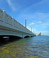
 The westernmost of the two drawbridges on the causeway, with its draw span opened for a boat
 -
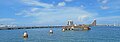
 View from water level towards Miami Beach
 -
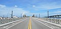 View towards Miami Beach
 -
 The Venetian Causeway viewed from former site of The Miami Herald
 -
 Entrance to Venetian Causeway from Miami side
 -
 Column with Sign
 -
 Bridge detail, lamps and railing
 -
 Entrance to Venetian Causeway with Columns view towards southeast


References
- ^ "National Register Information System". National Register of Historic Places. National Park Service. March 15, 2006.
- ^ "Venetian Causeway - Miami-Dade County".
- ^ "National Register Information System". National Register of Historic Places. National Park Service. 2006-03-15. Archived from the original on 2010-05-27.
- ^ Miami-Dade County Public Works department
- ^ "Venetian Causeway - Miami-Dade County".
- ^ "Venetian Causeway". Retrieved March 21, 2021.
- ^ The City of Miami Beach Community Bridges The Past With The New Millennium Archived 2006-10-05 at the Wayback Machine, October 28, 1999
- ^ Viglucci, Andres (March 5, 2023). "Eleven bridges on Miami's historic 1926 Venetian Causeway will be demolished, rebuilt". Miami Herald. Retrieved March 6, 2023.
External links
Wikimedia Commons has media related to Venetian Causeway.
- New York Times Article (March 21, 2008): Islands of Calm
- v
- t
- e
- Downtown Miami
- Arts & Entertainment District
- Brickell
- Central Business District
- Historic District
- Government Center
- Park West
and universities
- Barry University
- Broward College
- Carlos Albizu University
- Florida Atlantic University
- Florida International University
- Florida Memorial University
- Johnson & Wales University
- Miami Dade College
- Miami International University of Art & Design
- Nova Southeastern University
- St. Thomas University
- University of Fort Lauderdale
- University of Miami
- Alice Wainwright Park
- Amelia Earhart Park
- Arch Creek
- The Barnacle Historic State Park
- Bayfront Park
- Big Cypress National Preserve
- Bill Baggs Cape Florida State Park
- Biscayne National Park
- Brian Piccolo Sports Park & Velodrome
- Chapman Field Park
- Crandon Park
- Dinner Key
- Everglades National Park
- Fairchild Tropical Botanic Garden
- Fort Dallas
- Fruit & Spice Park
- Greynolds Park
- Haulover Park
- Jungle Island
- The Kampong
- Margaret Pace Park
- Matheson Hammock Park
- Miami Seaquarium
- Monkey Jungle
- Museum Park
- Oleta River State Park
- Peacock Park
- Pride Park, Miami Beach FL
- Shark Valley
- Simpson Park Hammock
- South Pointe Park
- Tamiami Park
- Tropical Park
- The Underline
- Virginia Key
- Zoo Miami
- Adrienne Arsht Center for the Performing Arts
- Bass Museum
- Bergeron Rodeo Grounds
- Biltmore Hotel
- Bonita Chita Key
- Butterfly World
- Coral Castle
- Downtown Miami
- FIU Arena
- FIU Stadium
- FLA Live Arena
- Florida Grand Opera
- Fontainebleau Miami Beach
- Fort Lauderdale Swap Shop
- Frost Art Museum
- Frost School of Music
- Gulfstream Park
- Hard Rock Stadium
- HistoryMiami
- Holocaust Memorial
- Homestead
- Jewish Museum of Florida
- Kaseya Center
- Las Olas Boulevard
- LoanDepot Park
- Lowe Art Museum
- Lincoln Road
- Lummus Park
- MacFarlane Homestead
- Miami Beach Architectural District
- Miami Beach Convention Center
- Miami Children's Museum
- Miami City Ballet
- Miami Conservatory
- Museum of Contemporary Art
- New World Symphony Orchestra
- Normandy Isles
- North Shore
- Ocean Drive
- Phillip and Patricia Frost Museum of Science
- Pérez Art Museum Miami
- Riverwalk
- Seminole Hard Rock Hotel & Casino Hollywood
- South Beach
- The Miami Line
- Vizcaya Museum and Gardens
- Watsco Center
- Wolfsonian-FIU
- Wynwood Art District
- Aventura Mall
- Bal Harbour Shops
- Bayside Marketplace
- Boynton Beach Mall
- Brickell City Centre
- Broward Mall
- CocoWalk
- Coral Square
- Dadeland Mall
- Dolphin Mall
- The Falls
- The Galleria at Fort Lauderdale
- The Gardens Mall
- Lincoln Road
- The Mall at 163rd Street
- Mary Brickell Village
- Miami International Mall
- Midtown Miami
- Midway Crossings
- Miracle Marketplace
- Pembroke Lakes Mall
- The Promenade at Coconut Creek
- The Shops at Sunset Place
- Sawgrass Mills
- Southland Mall
- Shops at Merrick Park
- Town Center at Boca Raton
- Westland Mall
- Amtrak
- Broward County Transit
- Brightline
- Government Center
- Fort Lauderdale Executive Airport
- Fort Lauderdale–Hollywood International Airport
- Miami-Dade Transit
- Metrobus
- Metromover
- Metrorail
- MIA Mover
- MiamiCentral
- Miami Intermodal Center
- Miami International Airport
- Miami-Opa Locka Executive Airport
- North Perry Airport
- Palm Beach International Airport
- Palm Tran
- Pompano Beach Airpark
- Port Everglades
- Port of Miami
- Tri-Rail
- East 6th Avenue
- North 36th Street
- North 54th Street
- North 79th Street
- North 103rd Street
- North 125th Street
- North 135th Street
- West 7th Avenue
- West 12th Avenue
- West 27th Avenue
- West 107th Avenue
- Allapattah Road
- Alton Road
- Bird Road
- Biscayne Boulevard
- Brickell Avenue
- Broad Causeway
- Collins Avenue
- Coral Reef Drive
- Coral Way
- County Line Road
- Douglas Road
- Flagler Street
- Galloway Road
- Gratigny
- Ives Dairy Road
- Julia Tuttle Causeway
- Kendall Drive
- John F. Kennedy Causeway
- Killian
- Krome Avenue
- William Lehman Causeway
- Le Jeune Road
- Ludlam Road
- MacArthur Causeway
- Miami Avenue
- Miami Gardens Drive
- Milam Dairy Road
- Miracle Mile
- Okeechobee Road
- Old Cutler Road
- Port Boulevard
- Quail Roost Drive
- Red Road
- Rickenbacker Causeway
- South Dixie Highway
- Sunset Drive
- Tamiami Trail
- University Drive
- Venetian Causeway
- West Dixie Highway
 WikiProject
Crossings of the Biscayne Bay | ||||
|---|---|---|---|---|
| ||||


