Tunsel
Ortsteil of Bad Krozingen in Baden-Württemberg, Germany

Coat of arms
Location of Tunsel

47°54′12″N 7°40′11″E / 47.90333°N 7.66972°E / 47.90333; 7.66972
(2020)[1]
79189
Tunsel is a village in the district of Breisgau-Hochschwarzwald in Baden-Württemberg. Since January 1974, it is an Ortsteil of Bad Krozingen.[2]
Gallery
-
 St. Michael Church
 -
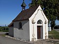 Maria-Hilf Kapelle (Our Lady Help of Christians Chapel)
 -
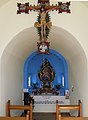 Inside Maria-Hilf Kapelle


References

Authority control databases | |
|---|---|
| International |
|
| National |
|
 | This Breisgau-Hochschwarzwald location article is a stub. You can help Wikipedia by expanding it. |
- v
- t
- e


