Tim Mei Avenue
Tim Mei Avenue (Chinese: 添美道; Jyutping: tim1 mei5 dou6; pinyin: Tiānměi Dào) is a street in Admiralty, Hong Kong.
The street is built on land reclaimed as part of the Central Reclamation Phase II,[1] which was completed in 1997 and reclaimed 5.3 hectares of land at the former Tamar naval base.[2] The area was subsequently known as the Tamar site. Tim Mei Avenue connects Harcourt Road and Lung Wo Road (龍和道). Buildings along the street include CITIC Tower[3] and the Central Government Complex.[4]
Civic Square
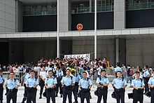
Civic Square, whose access is from Tim Mei Avenue, was conceived as public open space accessible to all. The square was however closed off in July 2014 after protesters opposed to the creation of new towns in certain parts of the New Territories gathered in the square and stormed into the Legislative Council (LegCo) complex from there.[5] The government erected a 3-metre (9.8 ft) fence all around the square for security costing around HK$2 million without consulting LegCo. Since early September, the government reopened the square to the public, daily between 6am and 11pm.[6]
A student-led march in protest against the framework for electoral reform of the election of the chief executive by universal suffrage announced by the NPC Standing Committee to "reclaim" the privatised Civic Square was a trigger for the Umbrella Revolution.[7]
References
- ^ Lands Department: "Tender Result Records". Address listes as "Tim Mei Avenue, Central Reclamation Phase II"
- ^ Hong Kong Harbour Reclamation – FactBox – Central Harbour Reclamation Phase 1 & 2
- ^ Emporis: CITIC Tower
- ^ Transport Department: Public Transport Services and Traffic Arrangements for Tamar Archived 2013-05-10 at the Wayback Machine
- ^ "How Civic Square has become less than friendly". The Standard, 29 September 2014
- ^ "High security at Tamar square with 3m fence". The Standard, 11 September 2014
- ^ "Meet the 17-year-old face of Hong Kong's protests". USA Today. 2 October 2014. Retrieved 8 October 2014.
External links
 Media related to Tim Mei Avenue, Hong Kong at Wikimedia Commons
- v
- t
- e
Main borders and locations
- Landmarks in Central
- Bank of America Tower
- Bonham Road
- British Consulate
- Breezy Path
- Central and Western Heritage Trail
- Civic Square
- First houses on the Peak
- Gate Lodge
- Grenville House
- Harcourt Garden
- Headquarters House
- High West
- Hong Kong Museum of Medical Sciences
- Hong Kong Zoological and Botanical Gardens
- Island Pacific Hotel
- King George V Memorial Park
- Lippo Centre
- Lung Fu Shan Country Park
- Mount Davis
- Mountain Lodge
- Ohel Leah Synagogue
- Old Tsan Yuk Maternity Hospital
- The Peak Galleria
- Hong Kong Trams Station (former)
- Pacific Place Phases I-II
- Peak Tower
- Queensway
- Sai Ying Pun Community Complex
- SoHo
- Shun Tak Centre
- South Korean Consulate
- Smithfield
- Tamar Park
- Tim Mei Avenue
- Tsan Yuk Hospital
- Victoria Peak Garden
| MTR stations |
|
|---|---|
| Ferry terminals | |
| Tram |
This list is incomplete. Central has its own template due to the number of sites in that area.
Sites specifically associated with University of Hong Kong are listed at the relevant template.
Sites specifically associated with University of Hong Kong are listed at the relevant template.
22°16′49″N 114°09′59″E / 22.280236°N 114.166488°E / 22.280236; 114.166488
 | This Hong Kong road article is a stub. You can help Wikipedia by expanding it. |
- v
- t
- e


