South Cumberland State Park
State park in Tennessee
35°15′32″N 85°47′20″W / 35.259°N 85.789°W / 35.259; -85.789
South Cumberland State Park is a state park in the middle and southeast portions of Tennessee on the Cumberland Plateau.
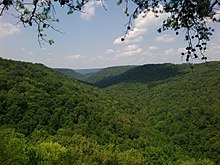
The park is one of Tennessee's newer state parks, established in 1978. It is a collection of nine discrete tracts scattered across Franklin, Marion, Grundy and Sequatchie counties, totaling approximately 30,899 acres (as of 2020).[1] Twelve trailheads provide hiking access to most sections of the park,[2] which protects a series of unique ecosystems on the escarpments and in the ravines of the Southern Cumberland Plateau. There are over a dozen large waterfalls in the park,[3] the tallest of which is Foster Falls, in Marion County. The Grundy Lakes unit includes industrial archaeological remains of the coal mines and coke production facilities of the Tennessee Coal, Iron and Railroad Company, as well as a stockade prison it operated that provided convict labor for those facilities.[4]
Areas
Distinct areas contained within the park include:
- Savage Gulf State Natural Area (until 2023 when it was separated into a new state park)
- Fiery Gizzard Trail
- Grundy Forest State Natural Area
- Grundy Lakes
- Denny Cove
- Carter State Natural Area (Lost Cove ["Buggytop"] Cave)
- Foster Falls
- Sewanee Natural Bridge State Natural Area
- Hawkins Cove State Natural Area
- Sherwood Forest
Savage Gulf State Natural Area has been named as a National Natural Landmark.[5] Crossing in and out of the park's various sections, the Fiery Gizzard Trail is renowned for its beauty and diversity.[6]
Camping
Camping may be done at the park's Foster Falls Campground, which includes 26 tent/pop-up camper sites and 93 backcountry campsites throughout the park.
See also
- Collins River
External links
- South Cumberland State Park
- Tennessee Natural Areas - Savage Gulf
- Tennessee Natural Areas - Mr. and Mrs. Harry Lee Carter Natural Area
- Tennessee Natural Areas - Grundy Forest
- Tennessee Natural Areas - Hawkins Cove
- Friends of South Cumberland State Park
References
- ^ "TN Property Viewer". Archived from the original on July 20, 2011.
- ^ "Trailhead and Trail Info - Friends of South Cumberland State Park".
- ^ "Waterfalls - Friends of South Cumberland State Park".
- ^ "Ghosts of Lone Rock". Sewanee: The University of the South. Retrieved September 19, 2022.
- ^ "National Natural Landmarks - National Natural Landmarks (U.S. National Park Service)". www.nps.gov. Retrieved March 28, 2019.
Year designated: 1971
- ^ "Fiery Gizzard Trail: Difficult but interesting overnight trail along Fiery Creek Gorge". Secret Falls. Retrieved May 6, 2012.
- v
- t
- e
Protected areas of Tennessee
| National parks | |
|---|---|
| National historical parks and sites | |
| National Military Parks | |
| National recreation areas | |
| National Trails System | |
| National forests | |
| National Wild and Scenic Rivers | |
| National Wildlife Refuges | |
| Wilderness areas |
|
| Other protected areas |
| East Tennessee state parks |
|
|---|---|
| Middle Tennessee state parks |
|
| West Tennessee state parks | |
| State forests |
|
| State natural areas |
|
| Other |
 | This Grundy County, Tennessee geography–related article is a stub. You can help Wikipedia by expanding it. |
- v
- t
- e
 | This Sequatchie County, Tennessee geography–related article is a stub. You can help Wikipedia by expanding it. |
- v
- t
- e
 | This Franklin County, Tennessee geography–related article is a stub. You can help Wikipedia by expanding it. |
- v
- t
- e
This article related to a protected area in Tennessee is a stub. You can help Wikipedia by expanding it. |
- v
- t
- e


