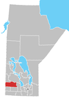
Rural Municipality of Harrison
The Rural Municipality of Harrison is a former rural municipality (RM) in the Canadian province of Manitoba. It was originally incorporated as a rural municipality on December 22, 1883.[1] It ceased on January 1, 2015 as a result of its provincially mandated amalgamation with the RM of Park to form the Municipality of Harrison Park.[2]
The RM was located north of Brandon on the Yellowhead Highway with its offices at Newdale, Manitoba. The main reserve of the Rolling River First Nation lied within the east-central portion of the RM. The RM was named for David Howard Harrison who became premier of Manitoba in 1887.
Communities
- Newdale
- Rackham
- Sandy Lake
External links
- Official website
References
- ^ "Manitoba's Municipal History: Rural Municipalities and Local Government Districts". The Manitoba Historical Society. September 21, 2014. Retrieved January 2, 2015.
- ^ "Manitoba's Municipal History: Municipal Amalgamations (2015)". The Manitoba Historical Society. December 1, 2014. Retrieved January 2, 2015.
- Map of Harrison R.M. at Statcan
- Geographic Names of Manitoba (pg. 106) - the Millennium Bureau of Canada
- Manitoba Historical Society - Manitoba Municipalities: Rural Municipality of Harrison
- v
- t
- e
- Minnedosa
- Neepawa
| Former towns |
|
|---|

| Former villages |
|---|
| Former RMs |
|---|
50°27′42″N 100°05′31″W / 50.46167°N 100.09194°W / 50.46167; -100.09194
 | This Manitoba location article is a stub. You can help Wikipedia by expanding it. |
- v
- t
- e


