Robespierre station
Metro station in Paris, France
48°51′20″N 2°25′25″E / 48.855683°N 2.423678°E / 48.855683; 2.423678
| Preceding station | Following station | |||
|---|---|---|---|---|
| Porte de Montreuil towards Pont de Sèvres | Line 9 | Croix de Chavaux towards Mairie de Montreuil | ||
Location | |
|---|---|
  Robespierre Location within Paris |
Robespierre (French pronunciation: [ʁɔbɛspjɛʁ] ⓘ) is a station on line 9 of the Paris Métro. It is named after the nearby on the rue Robespierre, which was named after Maximilien de Robespierre (1758 – 1794), who was one of the best-known leaders of the French Revolution. It is located in the commune of Montreuil, Seine-Saint-Denis, just to the east of Paris.
History
The station was opened on 14 October 1937 with the extension of the line from Porte de Montreuil to Mairie de Montreuil.
In 2019, the station was used by 4,221,091 passengers, making it the 109th busiest of the Métro network out of 302 stations.[1]
In 2020, the station was used by 2,281,953 passengers amidst the COVID-19 pandemic, making it the 100th busiest of the Métro network out of 305 stations.[2]
Passenger services
Access
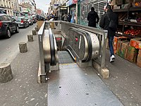
The station has 2 accesses:
- Access 1: rue Robespierre
- Access 2: rue Barbès (Art Deco style)
Station layout
| Street Level | ||
| B1 | Mezzanine | |
| Line 9 platforms | Side platform, doors will open on the right | |
| Westbound | ←  | |
| Eastbound | → | |
| Side platform, doors will open on the right | ||
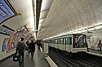
Platforms
The station has a standard configuration with 2 tracks surrounded by 2 side platforms.
Other connections
The station is also served by line 318 of the RATP bus network.
Gallery
-
 Entrance 1
 -
 Entrance 1
 -
 Entrance 2
 -


Wikimedia Commons has media related to Robespierre (Paris Metro).
References
- Roland, Gérard (2003). Stations de métro. D’Abbesses à Wagram. Éditions Bonneton.
- ^ "Trafic annuel entrant par station du réseau ferré 2019". dataratp2.opendatasoft.com (in French). Archived from the original on 21 January 2022. Retrieved 15 February 2022.
- ^ "Trafic annuel entrant par station du réseau ferré 2020". data.ratp.fr (in French). Archived from the original on 21 January 2022. Retrieved 15 February 2022.
- v
- t
- e
- Pont de Sèvres


- Billancourt
- Marcel Sembat
- Porte de Saint-Cloud
- Exelmans
- Michel-Ange–Molitor (eastbound only)


- Michel-Ange–Auteuil (westbound only)
- Jasmin
- Ranelagh
- La Muette
- Rue de la Pompe
- Trocadéro

- Iéna
- Alma–Marceau
- Franklin D. Roosevelt

- Saint-Philippe du Roule
- Miromesnil

- Saint-Augustin

- Havre–Caumartin


- Chaussée d'Antin–La Fayette

- Richelieu–Drouot

- Grands Boulevards
- Bonne Nouvelle
- Strasbourg–Saint-Denis

- République


- Oberkampf
- Saint-Ambroise
- Voltaire
- Charonne
- Rue des Boulets
- Nation

- Buzenval
- Maraîchers
- Porte de Montreuil

- Robespierre
- Croix de Chavaux
- Mairie de Montreuil
- Aristide Briand (planned)
- Montreuil-Hôpital (planned)
| Authority control databases |
|
|---|
This article related to the Paris Métro is a stub. You can help Wikipedia by expanding it. |
- v
- t
- e


