Ridderkerk
Municipality in South Holland, Netherlands

Flag

Coat of arms

Location in South Holland
(January 2021)[4]
2980–2989
Ridderkerk (Dutch pronunciation: [ˌrɪdərˈkɛr(ə)k] ⓘ) is a town and municipality in the western Netherlands, in the province of South Holland. The municipality had a population of 46,671 in 2021 and covers an area of 25.26 km2 (9.75 sq mi) of which 1.54 km2 (0.59 sq mi) is covered by water.
The municipality of Ridderkerk also includes the following towns, villages and townships: Bolnes, Oostendam, Rijsoord and Slikkerveer.
Ridderkerk has a museum called De Oudheidkamer, covering the history of the town. The centre of Ridderkerk has a central square for events and there is a theater.
Public transport
- Waterbus
- At the Waterbus stop "de Schans" you can board the number 20 Waterbus to Dordrecht, Papendrecht, Hendrik Ido Ambacht, Alblasserdam, Krimpen aan den IJssel or Rotterdam.
- At the Waterbus stop "de Schans" you can also take line 6 to: Krimpen aan de Lek and Kinderdijk.
- Buses
- The bus services are mostly operated by RET and they go to Rotterdam, Barendrecht and Dordrecht. There are two Arriva bus services to Zwijndrecht and Hendrik Ido Ambacht.
Topography

Topographic map of the municipality of Ridderkerk
Notable people


- Leen van der Waal (1928–2020), politician, former Member of the European Parliament
- Jan van der Graaf (1937–2022), church administrator
- Rien Kaashoek (born 1937), mathematician and academic
- Luuk Kroon (1942–2012), naval officer, Commander of the Royal Netherlands Navy 1995-1998
- Bas Belder (born 1946), politician, former Member of the European Parliament
- Lee Towers (born 1946), singer
- Gert Oostindie (born 1955), historian and professor[5]
- Martin van Beek (1960–2018), politician, former senator
- Robbert Dijkgraaf FRSE (born 1960), mathematical physicist and politician, string theorist and minister
- Jos Wienen (born 1960), politician, former alderman of Ridderkerk, mayor of Haarlem
- Johan Schot CBE (born 1961), historian working on science and technology policy
- Cora van Nieuwenhuizen (born 1963), politician, former minister
- Flora Lagerwerf-Vergunst (born 1964), judge and politician, former senator
- Bart Jan Spruyt (born 1964), historian, journalist and conservative writer
- Liesbeth Zegveld (born 1970), lawyer, legal expert and professor
- André Flach (born 1976), Dutch politician
Sport
- Gerrit Lagendijk (1941–2010), professional football player and agent
- Wietske de Ruiter (born 1970), female former field hockey striker, team bronze medallist at the 1996 Summer Olympics
- Maurice Lim (born 1984), figure skating champion
- Jordy Buijs (born 1988), footballer, over 250 club caps
- Kevin Strootman (born 1990), footballer, nearly 300 club caps
- Bart Deurloo (born 1991), male artistic gymnast
- Tim Eekman (born 1991), professional footballer, almost 200 club caps
- Mick van Buren (born 1992), footballer, 150 club caps
Gallery
-
 Ridderkerk in 1584
 -
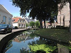 Ridderkerk Kerksingel
 -
 Ridderkerk, church: Singelkerk Sint Joris
 -
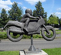 Ridderkerk kunstwerk motorrijder
 -
 Ridderkerk kunstwerk ontmoetingspoort


References
- ^ "Burgemeester en wethouders" [Mayor and aldermen] (in Dutch). Gemeente Ridderkerk. Retrieved 18 August 2013.
- ^ "Kerncijfers wijken en buurten 2020" [Key figures for neighbourhoods 2020]. StatLine (in Dutch). CBS. 24 July 2020. Retrieved 19 September 2020.
- ^ "Postcodetool for 2981EA". Actueel Hoogtebestand Nederland (in Dutch). Het Waterschapshuis. Retrieved 18 August 2013.
- ^ "Bevolkingsontwikkeling; regio per maand" [Population growth; regions per month]. CBS Statline (in Dutch). CBS. 1 January 2021. Retrieved 2 January 2022.
- ^ "Surinamistiekprijs 2010 voor Gert Oostindie". Werkgroep Caraibische Letteren (in Dutch). 6 November 2010. Retrieved 24 January 2022.
External links
Wikimedia Commons has media related to Ridderkerk.
- Official website (in Dutch)
Places adjacent to Ridderkerk | ||||||||||||||||
|---|---|---|---|---|---|---|---|---|---|---|---|---|---|---|---|---|
| ||||||||||||||||


- v
- t
- e
- Alblasserdam
- Albrandswaard
- Alphen aan den Rijn
- Barendrecht
- Bodegraven-Reeuwijk
- Capelle aan den IJssel
- Delft
- Dordrecht
- Goeree-Overflakkee
- Gorinchem
- Gouda
- Hardinxveld-Giessendam
- Hendrik-Ido-Ambacht
- Hillegom
- Hoeksche Waard
- Kaag en Braassem
- Katwijk
- Krimpen aan den IJssel
- Krimpenerwaard
- Lansingerland
- Leiden
- Leiderdorp
- Leidschendam-Voorburg
- Lisse
- Maassluis
- Midden-Delfland
- Molenlanden
- Nieuwkoop
- Nissewaard
- Noordwijk
- Oegstgeest
- Papendrecht
- Pijnacker-Nootdorp
- Ridderkerk
- Rijswijk
- Rotterdam
- Schiedam
- Sliedrecht
- Teylingen
- The Hague
- Vlaardingen
- Voorne aan Zee
- Voorschoten
- Waddinxveen
- Wassenaar
- Westland
- Zoetermeer
- Zoeterwoude
- Zuidplas
- Zwijndrecht

- See also
- Netherlands
- Provinces
- Municipalities
Authority control databases | |
|---|---|
| International |
|
| National |
|
| Geographic |
|
 | This South Holland location article is a stub. You can help Wikipedia by expanding it. |
- v
- t
- e


