Ravar
City in Kerman province, Iran
City in Kerman, Iran
Ravar Persian: راور | |
|---|---|
City | |
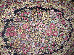 Ravar carpet | |
| 31°15′48″N 56°48′26″E / 31.26333°N 56.80722°E / 31.26333; 56.80722[1] | |
| Country | Iran |
| Province | Kerman |
| County | Ravar |
| District | Central |
| Elevation | 1,755 m (5,758 ft) |
| Population (2016)[2] | |
| • Total | 19,800 |
| Time zone | UTC+3:30 (IRST) |
Ravar (Persian: راور)[a] is a city in the Central District of Ravar County, Kerman province, Iran, serving as capital of both the county and the district.[4] Known as the national carpet city of Iran, Ravar produces a distinctive type of Kerman carpet, and is also well known for its vast pistachio fields.[5]
At the 2006 National Census, its population was 18.500 in 5,921 households.[6] The following census in 2011 counted 19.100 people in 6,260 households.[7] The latest census in 2016 showed a population of 19,800 people in 6,874 households.[2]
 Iran portal

Notes
References
- ^ OpenStreetMap contributors (4 July 2023). "Ravar, Ravar County" (Map). OpenStreetMap. Retrieved 4 July 2023.
- ^ a b "Census of the Islamic Republic of Iran, 1395 (2016)". AMAR (in Persian). The Statistical Center of Iran. p. 08. Archived from the original (Excel) on 20 October 2020. Retrieved 19 December 2022.
- ^ Ravar can be found at GEOnet Names Server, at this link, by opening the Advanced Search box, entering "-3080922" in the "Unique Feature Id" form, and clicking on "Search Database".
- ^ Habibi, Hassan (14 November 1375). "Changes in the country divisions in Kerman province". Lamtakam (in Persian). Ministry of Interior, Political-Defense Commission of the Government Council. Archived from the original on 1 February 2024. Retrieved 1 February 2024.
- ^ "Archived copy". Archived from the original on 30 July 2016. Retrieved 19 January 2020.
{{cite web}}: CS1 maint: archived copy as title (link) - ^ "Census of the Islamic Republic of Iran, 1385 (2006)". AMAR (in Persian). The Statistical Center of Iran. p. 08. Archived from the original (Excel) on 20 September 2011. Retrieved 25 September 2022.
- ^ "Census of the Islamic Republic of Iran, 1390 (2011)". Syracuse University (in Persian). The Statistical Center of Iran. p. 08. Archived from the original (Excel) on 29 March 2023. Retrieved 19 December 2022.
Authority control databases | |
|---|---|
| International |
|
| National |
|
Kerman province, Iran | ||
|---|---|---|
| Capital |  | |
| Counties and cities | ||
| Sights |
| |
| Places | ||

 | This Ravar County location article is a stub. You can help Wikipedia by expanding it. |
- v
- t
- e


