Pnětluky
Municipality in Ústí nad Labem, Czech Republic

Flag

Coat of arms
 Czech Republic
 (2023-01-01)[1]
440 01
Pnětluky (until 1923 Netluky; German: Netluk bei Laun) is a municipality and village in Louny District in the Ústí nad Labem Region of the Czech Republic. It has about 400 inhabitants.
Administrative parts
The village of Konětopy is an administrative part of Pnětluky.
Etymology
The name Pnětluky is derived from a term referring to people who beat the trunks hard. The name Konětopy means "drowning the horses" and was likely used mockingly.[2]
Geography
Pnětluky is located about 13 kilometres (8 mi) southwest of Louny and 49 km (30 mi) northwest of Prague. It lies in the Džbán range. The highest point is the hill Pravda at 484 m (1,588 ft) above sea level. The Pnětlucký Brook flows through the municipality.
History
The first written mention of Pnětluky is from 1250; Konětopy was first mentioned in 1357. The first fortress was established here in the 14th century, but in 1466, it was already abandoned. In the 15th century, Pnětluky was owned by members of the Kolowrat family. They had built the Pravda Castle and established the Pravda estate, which included Pnětluky and Konětopy.[2]
In 1523, the estate was bought by the Lobkowicz family. They had a new fort built in Pnětluky, which has been preserved to this day. During the Thirty Years' War, the village was devastated, including a church from the mid-14th century. The Pravda estate was then merged with Divec and later with Cítoliby. From 1802 to the 20th century, the Cítoliby estate was property of the House of Schwarzenberg. Since the first half of the 19th century, Konětopy was known for its hops.[2]
Demographics
|
|
| ||||||||||||||||||||||||||||||||||||||||||||||||||||||
| Source: Censuses[3][4] | ||||||||||||||||||||||||||||||||||||||||||||||||||||||||
Economy
Pnětluky is located in an area known for growing the Saaz hops.
Transport
The village of Konětopy is located on the railway line Most–Rakovník.
Sights
Remains of the Pravda Castle are located on the eponymous hill above the village. It ceased to be an aristocratic residence in the 16th century. It has been a tourist destination since the 18th century and is used for social and cultural purposes.[2]
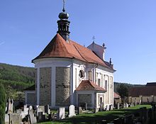
The Church of Saint Matthew is a late Baroque building from 1765.[5]
References
- ^ "Population of Municipalities – 1 January 2023". Czech Statistical Office. 2023-05-23.
- ^ a b c d "Historie" (in Czech). Obec Pnětluky. Retrieved 2022-09-07.
- ^ "Historický lexikon obcí České republiky 1869–2011 – Okres Louny" (in Czech). Czech Statistical Office. 2015-12-21. pp. 9–10.
- ^ "Population Census 2021: Population by sex". Public Database. Czech Statistical Office. 2021-03-27.
- ^ "Kostel sv. Matouše" (in Czech). National Heritage Institute. Retrieved 2022-09-07.
External links
Wikimedia Commons has media related to Pnětluky.
- Official website
- v
- t
- e
Towns, market towns and villages of Louny District
- Bitozeves
- Blatno
- Blažim
- Blšany
- Blšany u Loun
- Brodec
- Břvany
- Čeradice
- Černčice
- Chlumčany
- Chožov
- Chraberce
- Cítoliby
- Deštnice
- Dobroměřice
- Domoušice
- Holedeč
- Hříškov
- Hřivice
- Jimlín
- Koštice
- Kozly
- Krásný Dvůr
- Kryry
- Lenešice
- Libčeves
- Liběšice
- Libočany
- Libořice
- Lipno
- Lišany
- Líšťany
- Louny
- Lubenec
- Měcholupy
- Nepomyšl
- Nová Ves
- Nové Sedlo
- Obora
- Očihov
- Opočno
- Panenský Týnec
- Peruc
- Petrohrad
- Pnětluky
- Počedělice
- Podbořanský Rohozec
- Podbořany
- Postoloprty
- Raná
- Ročov
- Slavětín
- Smolnice
- Staňkovice
- Toužetín
- Tuchořice
- Úherce
- Velemyšleves
- Veltěže
- Vinařice
- Vrbno nad Lesy
- Vroutek
- Vršovice
- Výškov
- Zálužice
- Žatec
- Zbrašín
- Želkovice
- Žerotín
- Žiželice
| Authority control databases: National |
|
|---|


