Planica, Kranj
Place in Upper Carniola, Slovenia
46°12′46.08″N 14°16′58.42″E / 46.2128000°N 14.2828944°E / 46.2128000; 14.2828944 Slovenia
 (2002)
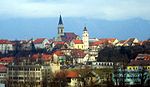
Planica (pronounced [plaˈniːtsa]) is a small settlement in the hills west of Kranj in the Upper Carniola region of Slovenia.[2]
Church

The church on a small hill above the settlement is dedicated to Archangel Gabriel and belongs to the Parish of Stara Loka.[3] It offers good views of the surrounding Škofja Loka Hills and part of the Kamnik Alps.[4] The church dates from the late 15th century and was destroyed by the Partisans in 1945. It was reconstructed in 1994 and reconsecrated in 1995.[5]
References
External links
 Media related to Planica at Wikimedia Commons
- Planica on Geopedia
- v
- t
- e
Administrative seat: Kranj

- Kieselstein Castle
- Kokra River Canyon
- Lake Trboje
- Plečnik Steps
- Schrottenturn Manor
- St. Cantianus and Companions Parish Church
- St. Judoc's Church
- St. Margaret's Hill
- Šum Falls
- Udin Woods
- Janez Bleiweis
- Davorin Dolar
- Lojze Dolinar
- Primož Grašič
- Boštjan Hladnik
- Simon Jenko
- Leopold Layer
- Peter Lipar
- Janez Mencinger
- Franc Novak
- Jože Plečnik
- Marko Pogačnik
- Ivan Pregelj
- Marij Pregelj
- France Prešeren
- Johann Pucher
- Edvard Ravnikar
- Andrej Šifrer
- Hinko Smrekar
- Marjan Šorli
- Andrej Štremfelj
- Tone Volčič


