Nuthetal
Municipality in Brandenburg, Germany
Location of Nuthetal within Potsdam-Mittelmark district

(2018–26) Ute Hustig[1]
(2022-12-31)[2]
14558
Nuthetal is a municipality in the Potsdam-Mittelmark district, in Brandenburg, Germany.
Geography
Nuthetal is situated south-west of Berlin. The area was formed from a series of large moraines during the last ice age. The municipality originated in October 2003 from the voluntary union of the independent municipalities Bergholz-Rehbrücke, Fahlhorst, Nudow, Philippsthal, Saarmund and Tremsdorf. The municipality owes its name to the rivulet Nuthe which flows between the places situated to the west Bergholz-Rehbrücke, Saarmund and Tremsdorf and the villages Nudow and Philippsthal situated to the east and flows into Havel in Potsdam.
Parts of the municipality
- Bergholz-Rehbrücke (5.600 Inhabitants)
- Fahlhorst (120 I.)
- Nudow (450 I.)
- Philippsthal (190 I.)
- Saarmund (1.450 I.)
- Tremsdorf (200 I.)
Demography
-
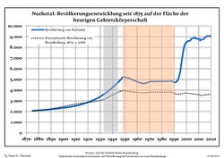 Development of population since 1875 within the current Boundaries (Blue Line: Population; Dotted Line: Comparison to Population development in Brandenburg state; Grey Background: Time of Nazi Germany; Red Background: Time of communist East Germany)
 -
 Recent Population Development and Projections (Population Development before Census 2011 (blue line); Recent Population Development according to the Census in Germany in 2011 (blue bordered line); Official projections for 2005-2030 (yellow line); for 2017-2030 (scarlet line); for 2020-2030 (green line)


|
|
|
Honorary citizen
The only honorary citizen buried here in Bergholz-Rehbrücke is the actress, singer and revue artiste Lotte Werkmeister.
References
- ^ Landkreis Potsdam-Mittelmark Wahl der Bürgermeisterin / des Bürgermeisters, accessed 2 July 2021.
- ^ "Bevölkerungsentwicklung und Bevölkerungsstandim Land Brandenburg Dezember 2022" (PDF). Amt für Statistik Berlin-Brandenburg (in German). June 2023.
- ^ Detailed data sources are to be found in the Wikimedia Commons.Population Projection Brandenburg at Wikimedia Commons
External links
- Official website
 (in German)
- v
- t
- e
Towns and municipalities in Potsdam-Mittelmark
- Bad Belzig
- Beelitz
- Beetzsee
- Beetzseeheide
- Bensdorf
- Borkheide
- Borkwalde
- Brück
- Buckautal
- Golzow
- Görzke
- Gräben
- Groß Kreutz
- Havelsee
- Kleinmachnow
- Kloster Lehnin
- Linthe
- Michendorf
- Mühlenfließ
- Niemegk
- Nuthetal
- Päwesin
- Planebruch
- Planetal
- Rabenstein
- Rosenau
- Roskow
- Schwielowsee
- Seddiner See
- Stahnsdorf
- Teltow
- Treuenbrietzen
- Wenzlow
- Werder
- Wiesenburg
- Wollin
- Wusterwitz
- Ziesar

Authority control databases | |
|---|---|
| International |
|
| National |
|
| Geographic |
|


