National Register of Historic Places listings in Trumbull County, Ohio

This is a list of the National Register of Historic Places listings in Trumbull County, Ohio.
This is intended to be a complete list of the properties and districts on the National Register of Historic Places in Trumbull County, Ohio, United States. The locations of National Register properties and districts for which the latitude and longitude coordinates are included below, may be seen in an online map.[1]
There are 38 properties and districts listed on the National Register in the county, including 1 National Historic Landmark. Another property was once listed but has been removed.
This National Park Service list is complete through NPS recent listings posted May 31, 2024.[2]
Map all coordinates using OpenStreetMap
Download coordinates as:
- KML
- GPX (all coordinates)
- GPX (primary coordinates)
- GPX (secondary coordinates)
Current listings
| [3] | Name on the Register[4] | Image | Date listed[5] | Location | City or town | Description |
|---|---|---|---|---|---|---|
| 1 | Dr. Peter Allen House |  | September 3, 1971 (#71000653) | W. Williamsfield State Rd., north of its intersection with State Route 87, in Kinsman 41°27′17″N 80°35′41″W / 41.454722°N 80.594722°W / 41.454722; -80.594722 (Dr. Peter Allen House) | Kinsman Township | |
| 2 | Henry Barnhisel, II House |  | December 19, 1982 (#82001492) | 1011 N. State St. 41°09′52″N 80°42′19″W / 41.164444°N 80.705278°W / 41.164444; -80.705278 (Henry Barnhisel, II House) | Girard | |
| 3 | Brookfield Center Historic District |  | October 10, 1985 (#85002922) | Roughly the western side of State Route 7 from Sharon-Warren Rd. to N. Wood St. and Brookfield Village Green 41°13′59″N 80°34′06″W / 41.233056°N 80.568333°W / 41.233056; -80.568333 (Brookfield Center Historic District) | Brookfield Township | |
| 4 | Charles Brown Gothic Cottage |  | May 28, 1975 (#75001545) | State Route 45, S. in North Bloomfield 41°27′36″N 80°52′08″W / 41.460000°N 80.868889°W / 41.460000; -80.868889 (Charles Brown Gothic Cottage) | Bloomfield Township | |
| 5 | Brown-Wing House |  | June 20, 1975 (#75001546) | Park West Rd. in North Bloomfield 41°27′50″N 80°52′29″W / 41.463889°N 80.874722°W / 41.463889; -80.874722 (Brown-Wing House) | Bloomfield Township | |
| 6 | Brownwood |  | September 3, 1971 (#71000655) | State Route 45 in North Bloomfield 41°27′39″N 80°51′21″W / 41.460833°N 80.855833°W / 41.460833; -80.855833 (Brownwood) | Bloomfield Township | |
| 7 | Congregational-Presbyterian Church |  | September 3, 1971 (#71000654) | Near State Routes 5 and 7 in Kinsman 41°26′56″N 80°35′21″W / 41.448889°N 80.589167°W / 41.448889; -80.589167 (Congregational-Presbyterian Church) | Kinsman Township | |
| 8 | Clarence Darrow Octagon House |  | September 10, 1971 (#71001025) | State Routes 5 and 7 in Kinsman 41°26′59″N 80°35′04″W / 41.449722°N 80.584444°W / 41.449722; -80.584444 (Clarence Darrow Octagon House) | Kinsman Township | |
| 9 | Dunlap-Burnett-Moss House | Upload image | January 30, 2023 (#100008444) | 1499 Burnett St. (Twp. Hwy. 158) 41°08′48″N 80°45′58″W / 41.1467°N 80.7661°W / 41.1467; -80.7661 (Dunlap-Burnett-Moss House) | Mineral Ridge | |
| 10 | John Stark Edwards House |  | July 17, 1978 (#78002199) | 309 South St., SE. 41°14′03″N 80°49′00″W / 41.234167°N 80.816667°W / 41.234167; -80.816667 (John Stark Edwards House) | Warren | |
| 11 | Fowler Center Historic District |  | October 10, 1985 (#85002921) | Roughly the area around the Fowler Township Village Green at the junction of State Routes 193 and 305, in Fowler 41°18′39″N 80°39′23″W / 41.310833°N 80.656389°W / 41.310833; -80.656389 (Fowler Center Historic District) | Fowler Township | |
| 12 | Richard Garlick House |  | October 10, 1990 (#90001500) | 1025 Ravine Dr., north of Youngstown 41°08′49″N 80°38′36″W / 41.146944°N 80.643333°W / 41.146944; -80.643333 (Richard Garlick House) | Liberty Township | |
| 13 | Greene Township Center |  | March 8, 1978 (#78002198) | East of North Bloomfield on State Route 87 at Greene Center 41°27′41″N 80°45′44″W / 41.461389°N 80.762222°W / 41.461389; -80.762222 (Greene Township Center) | Greene Township | |
| 14 | Gustavus Center Historic District | 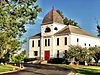 | August 6, 1975 (#75001542) | Town of Gustavus situated at the junction of State Routes 87 and 193 41°27′42″N 80°39′56″W / 41.461667°N 80.665556°W / 41.461667; -80.665556 (Gustavus Center Historic District) | Gustavus Township | |
| 15 | Charles Harshman House |  | July 7, 1983 (#83002062) | 3932 Painesville-Warren State Rd., NW. 41°19′35″N 80°56′39″W / 41.326389°N 80.944167°W / 41.326389; -80.944167 (Charles Harshman House) | Southington Township | |
| 16 | Elam Jones Public House |  | January 8, 2003 (#02001687) | 3365 State Route 7 in Hartford 41°18′43″N 80°34′05″W / 41.311806°N 80.568056°W / 41.311806; -80.568056 (Elam Jones Public House) | Hartford Township | |
| 17 | Mahoning Avenue Historic District |  | October 26, 1971 (#71000656) | 241-391 Mahoning Ave., NW.; also Mahoning Ave. between Perkins Dr. and High St. 41°14′19″N 80°49′22″W / 41.238611°N 80.822778°W / 41.238611; -80.822778 (Mahoning Avenue Historic District) | Warren | Second set of boundaries represents a boundary increase |
| 18 | John Wesley Mason Gothic Cottage |  | November 12, 1975 (#75001541) | Northwest of Braceville on State Route 534 41°14′49″N 80°58′33″W / 41.246806°N 80.975972°W / 41.246806; -80.975972 (John Wesley Mason Gothic Cottage) | Braceville Township | |
| 19 | Almon G. McCorkle House |  | March 10, 1982 (#82003659) | 1180 Salt Springs Rd. 41°09′59″N 80°50′28″W / 41.166389°N 80.841111°W / 41.166389; -80.841111 (Almon G. McCorkle House) | Lordstown | |
| 20 | McKinley Memorial |  | October 31, 1975 (#75001544) | 40 N. Main St. 41°10′51″N 80°45′58″W / 41.180833°N 80.766111°W / 41.180833; -80.766111 (McKinley Memorial) | Niles | Beaux-Arts memorial to President McKinley designed by McKim, Mead & White. |
| 21 | McLain-Gillmer House |  | June 15, 1978 (#78002200) | 720 Mahoning Ave., NW. 41°14′30″N 80°49′29″W / 41.241667°N 80.824722°W / 41.241667; -80.824722 (McLain-Gillmer House) | Warren | |
| 22 | Mesopotamia Village District |  | December 24, 1974 (#74001635) | State Routes 87 and 534 at Mesopotamia 41°27′37″N 80°57′16″W / 41.460278°N 80.954444°W / 41.460278; -80.954444 (Mesopotamia Village District) | Mesopotamia Township | |
| 23 | Newton Falls Covered Bridge |  | October 16, 1974 (#74001636) | Off State Route 534 41°11′17″N 80°58′17″W / 41.188056°N 80.971389°W / 41.188056; -80.971389 (Newton Falls Covered Bridge) | Newton Falls | |
| 24 | Newton Falls United Service Organization (USO) Center | Upload image | February 14, 2018 (#100002124) | 52 E. Quarry St. 41°11′03″N 80°58′30″W / 41.184065°N 80.975091°W / 41.184065; -80.975091 (Newton Falls United Service Organization (USO) Center) | Newton Falls | |
| 25 | Niles Masonic Temple |  | April 12, 2006 (#06000274) | 22 W. Church St. 41°10′55″N 80°45′58″W / 41.181944°N 80.766111°W / 41.181944; -80.766111 (Niles Masonic Temple) | Niles | |
| 26 | James Ward Packard House |  | October 31, 1985 (#85003577) | 319 Oak Knoll Ave., NE. 41°14′21″N 80°47′38″W / 41.239167°N 80.793889°W / 41.239167; -80.793889 (James Ward Packard House) | Warren | |
| 27 | Liberty G. Raymond Tavern and Barn |  | June 20, 1975 (#75001543) | State Route 87 and Dennison-Ashtabula Rd. in Kenilworth 41°27′44″N 80°44′18″W / 41.462222°N 80.738333°W / 41.462222; -80.738333 (Liberty G. Raymond Tavern and Barn) | Greene Township | |
| 28 | Dr. John W. Seely House |  | April 14, 1972 (#72001048) | 2245 Niles-Cortland Rd., south of Howland Corners 41°12′45″N 80°44′24″W / 41.212500°N 80.740000°W / 41.212500; -80.740000 (Dr. John W. Seely House) | Howland Township | |
| 29 | Southington Township School | 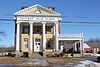 | February 4, 2011 (#10001214) | 4432 State Route 305 41°18′30″N 80°57′27″W / 41.308333°N 80.9575°W / 41.308333; -80.9575 (Southington Township School) | Southington Township | Originally listed as Chalker High School (10001214),[6] renamed Southington Township School and boundary expanded (12000464)[7] based on Ohio request to add adjacent elementary school and Civil War memorial.[8] |
| 30 | Swift-Kinsman House |  | March 22, 2016 (#16000114) | 8426 State Rd. 41°27′02″N 80°35′27″W / 41.450556°N 80.590833°W / 41.450556; -80.590833 (Swift-Kinsman House) | Kinsman Township | |
| 31 | Trumbull County Courthouse |  | December 31, 1974 (#74001637) | 160 High St., NW. 41°14′13″N 80°49′09″W / 41.236944°N 80.819167°W / 41.236944; -80.819167 (Trumbull County Courthouse) | Warren | |
| 32 | Harriet Taylor Upton House |  | October 5, 1992 (#92001884) | 380 Mahoning Ave., NW. 41°14′22″N 80°49′21″W / 41.239444°N 80.8225°W / 41.239444; -80.8225 (Harriet Taylor Upton House) | Warren | |
| 33 | Ward-Thomas House |  | February 9, 1984 (#84003809) | 503 Brown St. 41°10′26″N 80°45′53″W / 41.173889°N 80.764722°W / 41.173889; -80.764722 (Ward-Thomas House) | Niles | |
| 34 | Warren Commercial Historic District | 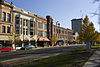 | June 16, 1983 (#83002063) | Roughly bounded by Mahoning, Monroe, Franklin, and Pine Sts. 41°14′17″N 80°49′13″W / 41.238056°N 80.820278°W / 41.238056; -80.820278 (Warren Commercial Historic District) | Warren | |
| 35 | Warren Public Library |  | March 20, 1973 (#73001543) | 120 High St., NW. 41°14′15″N 80°49′06″W / 41.2375°N 80.818333°W / 41.2375; -80.818333 (Warren Public Library) | Warren | |
| 36 | Wells-Clark-Strouss House |  | September 10, 1993 (#93000877) | 50 Warner Rd. at Logan Rd., east of Churchill 41°10′19″N 80°37′55″W / 41.171944°N 80.631944°W / 41.171944; -80.631944 (Wells-Clark-Strouss House) | Liberty Township | |
| 37 | William Woodrow House |  | July 15, 1982 (#82003658) | 138 Champion St., E., in Champion Heights 41°17′28″N 80°50′44″W / 41.291111°N 80.845556°W / 41.291111; -80.845556 (William Woodrow House) | Champion Township | |
| 38 | Youngstown Country Club | Upload image | February 5, 2024 (#100009888) | 1402 Country Club Drive 41°08′36″N 80°37′57″W / 41.1433°N 80.6326°W / 41.1433; -80.6326 (Youngstown Country Club) | Liberty Township |
Former listing
| [3] | Name on the Register | Image | Date listed | Date removed | Location | City or town | Description |
|---|---|---|---|---|---|---|---|
| 1 | Augustus Elwell House | Upload image | November 3, 1975 (#75001540) | April 1, 1980 | Northwest of Braceville on State Route 82 | Braceville |
See also
Wikimedia Commons has media related to National Register of Historic Places in Trumbull County, Ohio.
- List of National Historic Landmarks in Ohio
- Listings in neighboring counties: Ashtabula, Crawford (PA), Geauga, Mahoning, Mercer (PA), Portage
- National Register of Historic Places listings in Ohio
References
- ^ The latitude and longitude information provided in this table was derived originally from the National Register Information System, which has been found to be fairly accurate for about 99% of listings. Some locations in this table may have been corrected to current GPS standards.
- ^ National Park Service, United States Department of the Interior, "National Register of Historic Places: Weekly List Actions", retrieved May 31, 2024.
- ^ a b Numbers represent an alphabetical ordering by significant words. Various colorings, defined here, differentiate National Historic Landmarks and historic districts from other NRHP buildings, structures, sites or objects.
- ^ "National Register Information System". National Register of Historic Places. National Park Service. April 24, 2008.
- ^ The eight-digit number below each date is the number assigned to each location in the National Register Information System database, which can be viewed by clicking the number.
- ^ "Weekly list of actions taken on properties: 1/31/11 through 2/04/11". National Park Service. February 11, 2011. Retrieved September 3, 2015.
- ^ "Weekly list of actions taken on properties: 7/30/12 through 8/03/12". National Park Service. August 10, 2012. Retrieved September 3, 2015.
- ^ "Board recommends change to Southington historic site". Vindy.com. Archived from the original on 2012-04-21. Retrieved 3 September 2015.
- v
- t
- e
by county
- Adams
- Allen
- Ashland
- Ashtabula
- Athens
- Auglaize
- Belmont
- Brown
- Butler
- Carroll
- Champaign
- Clark
- Clermont
- Clinton
- Columbiana
- Coshocton
- Crawford
- Cuyahoga
- Darke
- Defiance
- Delaware
- Erie
- Fairfield
- Fayette
- Franklin
- Fulton
- Gallia
- Geauga
- Greene
- Guernsey
- Hamilton
- Hancock
- Hardin
- Harrison
- Henry
- Highland
- Hocking
- Holmes
- Huron
- Jackson
- Jefferson
- Knox
- Lake
- Lawrence
- Licking
- Logan
- Lorain
- Lucas
- Madison
- Mahoning
- Marion
- Medina
- Meigs
- Mercer
- Miami
- Monroe
- Montgomery
- Morgan
- Morrow
- Muskingum
- Noble
- Ottawa
- Paulding
- Perry
- Pickaway
- Pike
- Portage
- Preble
- Putnam
- Richland
- Ross
- Sandusky
- Scioto
- Seneca
- Shelby
- Stark
- Summit
- Trumbull
- Tuscarawas
- Union
- Van Wert
- Vinton
- Warren
- Washington
- Wayne
- Williams
- Wood
- Wyandot


