National Register of Historic Places listings in Snohomish County, Washington

The National Register of Historic Places (NRHP) is a list of districts, sites, buildings, structures, and objects in the United States that are designated for historic preservation. It is maintained by the National Park Service, a sub-agency of the federal Department of the Interior, and recognizes over 98,000 properties for their historic significance, artistic value, or other qualities.[1][2] The listing does not place restrictions on the use or fate of properties unless they receive federal funding or other assistance,[3] but does include tax credits for maintenance and rehabilitation of eligible sites.[4][5]
The NRHP has 1,500 listings in Washington and 50 that are partially or wholly within Snohomish County.[6] These properties include historic buildings in cities, fire lookouts in the Cascade Mountains, farms, monuments, and a ship.[7]
This National Park Service list is complete through NPS recent listings posted June 14, 2024.[8]
Current listings
| [9] | Name on the Register[10] | Image | Date listed[11] | Location | City or town | Description |
|---|---|---|---|---|---|---|
| 1 | Bates-Tanner Farm | 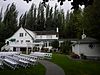 | March 9, 1995 (#95000189) | 3420 240th St. SE 47°46′50″N 122°11′06″W / 47.780556°N 122.185°W / 47.780556; -122.185 (Bates-Tanner Farm) | Bothell | Bothell MPS |
| 2 | Bush House |  | September 8, 2017 (#100001597) | 308 5th St. 47°49′12″N 121°33′15″W / 47.820047°N 121.554204°W / 47.820047; -121.554204 (Bush House) | Index | |
| 3 | Butler-Jackson House | 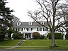 | May 14, 1998 (#97000494) | 1703 Grand Ave. 47°59′16″N 122°12′40″W / 47.987778°N 122.211111°W / 47.987778; -122.211111 (Butler-Jackson House) | Everett | |
| 4 | Andrew Carnegie Library |  | April 24, 1973 (#73001887) | 118 5th Ave., N. 47°48′40″N 122°22′32″W / 47.811111°N 122.375556°W / 47.811111; -122.375556 (Andrew Carnegie Library) | Edmonds | Carnegie Libraries of Washington TR (AD) |
| 5 | Commerce Building | 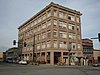 | October 1, 1992 (#92001290) | 1801 Hewitt Ave. 47°58′47″N 122°12′16″W / 47.979722°N 122.204444°W / 47.979722; -122.204444 (Commerce Building) | Everett | |
| 6 | Community Center and War Memorial Building | 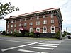 | February 26, 1979 (#79002554) | 1611 Everett Ave. 47°58′56″N 122°12′22″W / 47.982222°N 122.206111°W / 47.982222; -122.206111 (Community Center and War Memorial Building) | Everett | |
| 7 | Darrington Ranger Station |  | March 6, 1991 (#91000155) | 1405 Emmens St. 48°15′40″N 121°36′09″W / 48.261111°N 121.6025°W / 48.261111; -121.6025 (Darrington Ranger Station) | Darrington | |
| 8 | Equator (schooner) |  | April 14, 1972 (#72001281) | 14th St. Yacht Basin 47°59′52″N 122°12′50″W / 47.997778°N 122.213889°W / 47.997778; -122.213889 (Equator (schooner)) | Everett | |
| 9 | Everett Carnegie Library | 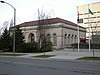 | December 6, 1975 (#75001868) | 3001 Oakes Ave. 47°58′40″N 122°12′10″W / 47.977778°N 122.202778°W / 47.977778; -122.202778 (Everett Carnegie Library) | Everett | Carnegie Libraries of Washington TR (AD) |
| 10 | Everett City Hall |  | May 2, 1990 (#90000674) | 3002 Wetmore Ave. 47°58′39″N 122°12′22″W / 47.9775°N 122.206111°W / 47.9775; -122.206111 (Everett City Hall) | Everett | Officially renamed the Mayor William E. Moore building in 2012. |
| 11 | Everett Fire Station No. 2 |  | May 2, 1990 (#90000673) | 2801 Oakes Ave. 47°58′50″N 122°12′10″W / 47.980556°N 122.202778°W / 47.980556; -122.202778 (Everett Fire Station No. 2) | Everett | |
| 12 | Everett High School |  | June 4, 1997 (#97000493) | 2400 Colby Ave. 47°59′07″N 122°12′29″W / 47.985278°N 122.208056°W / 47.985278; -122.208056 (Everett High School) | Everett | |
| 13 | Evergreen Mountain Lookout |  | July 14, 1987 (#87001187) | Skykomish Ranger District on SW ridgecrest of Evergreen Mountain 47°50′12″N 121°15′46″W / 47.836667°N 121.262778°W / 47.836667; -121.262778 (Evergreen Mountain Lookout) | Skykomish | |
| 14 | Floral Hall |  | April 26, 1990 (#90000671) | Forest Park 47°57′33″N 122°13′07″W / 47.959167°N 122.218611°W / 47.959167; -122.218611 (Floral Hall) | Everett | |
| 15 | Charles and Idalia Fratt House |  | May 8, 2017 (#100000991) | 1725 Grand Ave. 47°59′39″N 122°12′44″W / 47.994182°N 122.212173°W / 47.994182; -122.212173 (Charles and Idalia Fratt House) | Everett | |
| 16 | Green Mountain Lookout |  | February 22, 1988 (#88000117) | Darrington Ranger District 48°17′30″N 121°14′15″W / 48.291667°N 121.2375°W / 48.291667; -121.2375 (Green Mountain Lookout) | Darrington | |
| 17 | Grimm House | 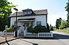 | March 9, 1995 (#95000191) | 2002 Hartford Dr. 48°00′57″N 122°03′44″W / 48.015833°N 122.062222°W / 48.015833; -122.062222 (Grimm House) | Lake Stevens | |
| 18 | Roland Hartley House | 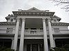 | May 2, 1986 (#86000958) | 2320 Rucker Ave. 47°59′12″N 122°12′37″W / 47.986667°N 122.210278°W / 47.986667; -122.210278 (Roland Hartley House) | Everett | |
| 19 | Hewitt Avenue Historic District |  | December 13, 2010 (#10001020) | 1620-1915 Hewitt Ave. and portions of Wetmore, Rockefeller, Oakes, and Lombard Ave. 47°58′45″N 122°12′19″W / 47.979167°N 122.205278°W / 47.979167; -122.205278 (Hewitt Avenue Historic District) | Everett | |
| 20 | Horseshoe Bend Placer Claim |  | May 7, 1981 (#81000590) | North of Sultan 47°55′41″N 121°48′20″W / 47.928056°N 121.805556°W / 47.928056; -121.805556 (Horseshoe Bend Placer Claim) | Sultan | |
| 21 | Indian Shaker Church |  | May 4, 1976 (#76001910) | West of Marysville, Tulalip Reservation, N. Meridan Ave. 48°02′32″N 122°13′52″W / 48.042222°N 122.231111°W / 48.042222; -122.231111 (Indian Shaker Church) | Marysville | An Indian Shaker Church denomination building, presumably |
| 22 | Keeler's Korner |  | April 29, 1982 (#82004287) | 16401 U.S. 99 47°51′00″N 122°17′30″W / 47.85°N 122.291667°W / 47.85; -122.291667 (Keeler's Korner) | Lynnwood | NRHP listing #51549. Gas station & grocery store dating from 1927. |
| 23 | Longfellow Elementary School |  | July 30, 2021 (#100006802) | 3715 Oakes Ave. 47°58′07″N 122°12′14″W / 47.9685°N 122.2039°W / 47.9685; -122.2039 (Longfellow Elementary School) | Everett | |
| 24 | Marysville Opera House |  | February 25, 1982 (#82004288) | 1225 3rd St. 48°03′04″N 122°10′46″W / 48.051111°N 122.179444°W / 48.051111; -122.179444 (Marysville Opera House) | Marysville | |
| 25 | McCabe Building |  | October 21, 1977 (#77001359) | 3120 Hewitt Ave. 47°58′44″N 122°11′15″W / 47.978889°N 122.1875°W / 47.978889; -122.1875 (McCabe Building) | Everett | |
| 26 | Miners Ridge Lookout | 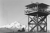 | July 19, 1987 (#87001183) | Darrington Ranger District in Glacier Peak Wilderness area 5 miles (8.0 km) west of Pacific Crest trail 48°12′26″N 121°01′41″W / 48.207222°N 121.028056°W / 48.207222; -121.028056 (Miners Ridge Lookout) | Darrington | |
| 27 | Monte Cristo Hotel | 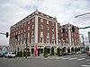 | June 3, 1976 (#76001907) | 1507 Wall St. 47°58′41″N 122°12′30″W / 47.978056°N 122.208333°W / 47.978056; -122.208333 (Monte Cristo Hotel) | Everett | |
| 28 | Mukilteo Light Station |  | October 21, 1977 (#77001360) | WA 525 47°56′56″N 122°18′18″W / 47.948889°N 122.305°W / 47.948889; -122.305 (Mukilteo Light Station) | Mukilteo | |
| 29 | Naval Auxiliary Air Station-Arlington |  | June 30, 1995 (#95000802) | 18204 59th Dr. NE., Arlington Municipal Airport Boundary increase (listed March 27, 2012, refnum 12000163): 18204 59th Dr., NE 48°09′49″N 122°09′33″W / 48.163611°N 122.159167°W / 48.163611; -122.159167 (Naval Auxiliary Air Station-Arlington) | Arlington | |
| 30 | North Coast Casket Company Building | 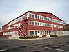 | August 8, 2006 (#06000700) | 1210 W. Marine View Dr. 48°00′10″N 122°12′54″W / 48.002778°N 122.215°W / 48.002778; -122.215 (North Coast Casket Company Building) | Everett | Now demolished. Deconstructed in 2011 by Port of Everett after lengthy battle on preservation vs. site redevelopment.[12] Commonly known as the Collins Building. |
| 31 | North Creek School |  | May 19, 1994 (#94000406) | 1129 208th Street SE 47°48′31″N 122°13′02″W / 47.8087°N 122.2173°W / 47.8087; -122.2173 (North Creek School) | Bothell | Moved to Centennial Park in 2008. |
| 32 | D. O. Pearson House |  | May 25, 1973 (#73001890) | Pearson and Market Sts. 48°14′31″N 122°22′11″W / 48.241944°N 122.369722°W / 48.241944; -122.369722 (D. O. Pearson House) | Stanwood | NRHP listing #73001890 Now part of the Stanwood Area History Museum. |
| 33 | Point Elliott Treaty Monument | 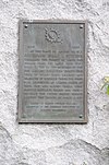 | April 14, 2004 (#04000316) | Jct. of Lincoln Ave. and 3rd St. 47°56′54″N 122°18′12″W / 47.948333°N 122.303333°W / 47.948333; -122.303333 (Point Elliott Treaty Monument) | Mukilteo | |
| 34 | Red Men Hall | 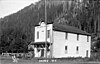 | April 13, 1973 (#73001889) | 530 Index Avenue 47°49′18″N 121°33′14″W / 47.821531°N 121.553946°W / 47.821531; -121.553946 (Red Men Hall) | Index | Collapsed January 1, 2009 |
| 35 | Rucker Hill Historic District | 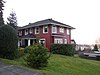 | November 8, 1989 (#89000399) | Roughly bounded by 32nd, Tulalip Ave., Bell Ave., Snohomish Ave., Laurel, and Warren 47°58′23″N 122°13′14″W / 47.973056°N 122.220556°W / 47.973056; -122.220556 (Rucker Hill Historic District) | Everett | |
| 36 | Rucker House | 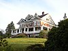 | December 4, 1975 (#75001869) | 412 Laurel Dr. 47°58′23″N 122°13′21″W / 47.973056°N 122.2225°W / 47.973056; -122.2225 (Rucker House) | Everett | |
| 37 | Snohomish County Courthouse | 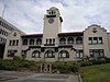 | December 6, 1975 (#75001870) | Wetmore Ave. between Wall St. and Pacific Ave. 47°58′39″N 122°12′19″W / 47.9775°N 122.205278°W / 47.9775; -122.205278 (Snohomish County Courthouse) | Everett | |
| 38 | Snohomish Historic District |  | October 22, 1974 (#74001978) | Roughly bounded by Ave. E, 5th St., Union Ave., Northern Pacific RR and Snohomish River 47°54′46″N 122°05′36″W / 47.912778°N 122.093333°W / 47.912778; -122.093333 (Snohomish Historic District) | Snohomish | |
| 39 | St. Anne's Roman Catholic Church | 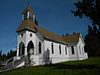 | June 18, 1976 (#76001911) | West of Marysville on Mission Beach Rd. 48°03′43″N 122°16′34″W / 48.061944°N 122.276111°W / 48.061944; -122.276111 (St. Anne's Roman Catholic Church) | Marysville | |
| 40 | Stanwood IOOF Public Hall | 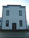 | February 21, 2002 (#02000087) | 27128 102nd Ave. NW 48°14′35″N 122°22′11″W / 48.243056°N 122.369722°W / 48.243056; -122.369722 (Stanwood IOOF Public Hall) | Stanwood | Now Floyd Norgaard Cultural Center. |
| 41 | Suiattle Guard Station |  | December 18, 1990 (#90001865) | Suiattle River east of Buck Cr., Mt. Baker-Snoqualmie NF 48°15′42″N 121°19′04″W / 48.261667°N 121.317778°W / 48.261667; -121.317778 (Suiattle Guard Station) | Darrington | |
| 42 | Swalwell Block and Adjoining Commercial Buildings | 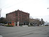 | May 17, 1976 (#76001908) | 2901-2909 and 2915 Hewitt Ave. 47°58′47″N 122°11′26″W / 47.979722°N 122.190556°W / 47.979722; -122.190556 (Swalwell Block and Adjoining Commercial Buildings) | Everett | |
| 43 | Swalwell Cottage |  | November 28, 1978 (#78002773) | 2712 Pine St. 47°58′53″N 122°11′29″W / 47.981389°N 122.191389°W / 47.981389; -122.191389 (Swalwell Cottage) | Everett | |
| 44 | Three Fingers Lookout |  | July 14, 1987 (#87001190) | Darrington Ranger District on the southernmost peak 48°10′12″N 121°41′11″W / 48.17°N 121.686389°W / 48.17; -121.686389 (Three Fingers Lookout) | Darrington | |
| 45 | Trafton School |  | October 30, 2006 (#06000730) | 12616 Jim Creek Rd. 48°14′19″N 122°03′36″W / 48.238611°N 122.06°W / 48.238611; -122.06 (Trafton School) | Arlington | Rural Public Schools of Washington State MPS |
| 46 | Tulalip Indian Agency Office |  | May 3, 1976 (#76001912) | 3901 Mission Beach Rd., Tulalip Reservation 48°03′56″N 122°17′04″W / 48.065556°N 122.284444°W / 48.065556; -122.284444 (Tulalip Indian Agency Office) | Marysville | |
| 47 | U.S. Post Office and Customshouse |  | June 22, 1976 (#76001909) | 3006 Colby Ave. 47°58′40″N 122°12′27″W / 47.977778°N 122.2075°W / 47.977778; -122.2075 (U.S. Post Office and Customshouse) | Everett | Also known as the Federal Building and as Peed Hall (from a recent period when it was owned by Cogswell College). |
| 48 | Verlot Ranger Station-Public Service Center |  | April 8, 1986 (#86000839) | Mt. Baker, Snoqualmie National Forest 48°05′38″N 121°46′46″W / 48.093889°N 121.779444°W / 48.093889; -121.779444 (Verlot Ranger Station-Public Service Center) | Granite Falls | NRHP listing #86000839 |
| 49 | Weyerhaeuser Timber Company Office Building |  | January 2, 2024 (#100009679) | 615 Millwright Loop N 48°00′05″N 122°13′17″W / 48.0013°N 122.2215°W / 48.0013; -122.2215 (Weyerhaeuser Timber Company Office Building) | Everett | Re-listed following delisting in 2022. |
| 50 | Winningham Farm |  | May 13, 1994 (#94000418) | 3214 228th St. SE. 47°47′28″N 122°10′55″W / 47.791111°N 122.181944°W / 47.791111; -122.181944 (Winningham Farm) | Bothell |
Former listings
| [9] | Name on the Register | Image | Date listed | Date removed | Location | City or town | Description |
|---|---|---|---|---|---|---|---|
| 1 | "Jack Knife" Bridge |  | July 16, 1982 (#73001888) | July 16, 1990 | Spans the Ebey Slough at Home Acres Rd. E of Everett 47°59′35″N 122°09′53″W / 47.992969°N 122.164661°W / 47.992969; -122.164661 ("Jack Knife" Bridge) | Everett vicinity | The bridge was replaced in its site spanning Ebey Slough. The image shows the formerly landmarked bridge in its new location. No longer a bascule, it now functions as a stationary footbridge to Spencer Island Park, crossing Union Slough east of Everett. |
| 2 | Weyerhaeuser Office Building |  | May 14, 1986 (#86001079) | December 19, 2022 | 1710 W. Marine View Dr. 47°59′43″N 122°12′47″W / 47.995278°N 122.213056°W / 47.995278; -122.213056 (Weyerhaeuser Office Building) | Everett | Re-listed in 2024 after move and renovation. |
See also
- National Register of Historic Places listings in Washington state
- Listings in neighboring counties: Chelan, Island, King, Kitsap, Skagit
- Historic preservation
- History of Washington (state)
- Index of Washington (state)-related articles
References
- ^ "National Register of Historic Places". United States General Services Administration. Retrieved June 5, 2024.
- ^ "What is the National Register of Historic Places?". National Park Service. Retrieved June 5, 2024.
- ^ "National Register of Historic Places: FAQs". National Park Service. Retrieved June 5, 2024.
- ^ Groover, Heidi (October 17, 2022). "Wallingford seeks historic status; some worry it's a roadblock to density". The Seattle Times. Retrieved June 5, 2024.
- ^ "Historic Registers". Washington State Department of Archaeology and Historic Preservation. Retrieved June 5, 2024.
- ^ "WISAARD (Washington Information System for Architectural and Archeological Records Data)". Washington State Department of Archaeology and Historic Preservation. Retrieved June 5, 2024.
- ^ "Designated historic sites in Snohomish County". The Everett Herald. July 5, 2012. Retrieved June 5, 2024.
- ^ National Park Service, United States Department of the Interior, "National Register of Historic Places: Weekly List Actions", retrieved June 14, 2024.
- ^ a b Numbers represent an alphabetical ordering by significant words. Various colorings, defined here, differentiate National Historic Landmarks and historic districts from other NRHP buildings, structures, sites or objects.
- ^ "National Register Information System". National Register of Historic Places. National Park Service. April 24, 2008.
- ^ The eight-digit number below each date is the number assigned to each location in the National Register Information System database, which can be viewed by clicking the number.
- ^ "Collins Building (North Coast Casket Company), Everett".
External links
Map all coordinates using OpenStreetMap
Download coordinates as:
- KML
- GPX (all coordinates)
- GPX (primary coordinates)
- GPX (secondary coordinates)
- Washington Department of Archaeology and Historic Preservation, Historic Register program
- National Park Service, National Register of Historic Places site
 Media related to National Register of Historic Places in Snohomish County, Washington at Wikimedia Commons
- v
- t
- e
National Register of Historic Places listings in Washington (state)
by county
- Adams
- Asotin
- Benton
- Chelan
- Clallam
- Clark
- Columbia
- Cowlitz
- Douglas
- Ferry
- Franklin
- Garfield
- Grant
- Grays Harbor
- Island
- Jefferson
- King
- Kitsap
- Kittitas
- Lewis
- Lincoln
- Mason
- Okanogan
- Pacific
- Pend Oreille
- Pierce
- San Juan
- Skagit
- Skamania
- Snohomish
- Spokane
- Stevens
- Thurston
- Wahkiakum
- Walla Walla
- Whatcom
- Whitman
- Yakima

- National Historic Landmarks
- Bridges and Tunnels
| |
|---|---|
| Topics | |
| Lists by state |
|
| Lists by insular areas | |
| Lists by associated state | |
| Other areas | |
| Related | |
| |


Municipalities and communities of Snohomish County, Washington, United States | ||
|---|---|---|
County seat: Everett | ||
| Cities |  | |
| Towns | ||
| CDPs |
| |
| Other communities | ||
| Indian reservation | ||
| Military bases | ||
| Ghost town |
| |
| Footnotes | ‡This populated place also has portions in an adjacent county or counties | |
| ||


