National Register of Historic Places listings in Otoe County, Nebraska
This is a list of the National Register of Historic Places listings in Otoe County, Nebraska.
This is intended to be a complete list of the properties and districts on the National Register of Historic Places in Otoe County, Nebraska, United States. The locations of National Register properties and districts for which the latitude and longitude coordinates are included below, may be seen in a map.[1]
There are 27 properties and districts listed on the National Register in the county, including 1 National Historic Landmark. Another two properties that were once listed have been removed.
This National Park Service list is complete through NPS recent listings posted June 14, 2024.[2]
Map all coordinates using OpenStreetMap
Download coordinates as:
- KML
- GPX (all coordinates)
- GPX (primary coordinates)
- GPX (secondary coordinates)
Current listings
| [3] | Name on the Register | Image | Date listed[4] | Location | City or town | Description |
|---|---|---|---|---|---|---|
| 1 | Arbor Lodge |  | April 16, 1969 (#69000135) | Arbor Lodge State Park, west of Nebraska City 40°40′49″N 95°52′42″W / 40.680278°N 95.878333°W / 40.680278; -95.878333 (Arbor Lodge) | Nebraska City | |
| 2 | Boscobel | 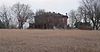 | June 17, 1976 (#76001133) | North of Nebraska City on Steamwagon Rd. 40°40′59″N 95°52′36″W / 40.683056°N 95.876667°W / 40.683056; -95.876667 (Boscobel) | Nebraska City | |
| 3 | Bridge | 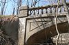 | June 29, 1992 (#92000737) | Unnamed stream, southwest of Nebraska City 40°41′45″N 95°53′01″W / 40.69572°N 95.88361°W / 40.69572; -95.88361 (Bridge) | Nebraska City | Road leading to bridge no longer exists.[5] Part of the Highway Bridges in Nebraska Multiple Property Submission (MPS). |
| 4 | Bridge |  | June 29, 1992 (#92000733) | County road over an unnamed stream, 4.1 miles (6.6 km) southwest of Lorton 40°34′01″N 96°05′26″W / 40.566944°N 96.090556°W / 40.566944; -96.090556 (Bridge) | Lorton | |
| 5 | Camp Creek Cemetery and Chapel |  | March 21, 2011 (#11000102) | Northeast corner of County Road P and S. 70th Rd. 40°34′04″N 95°48′08″W / 40.567778°N 95.802222°W / 40.567778; -95.802222 (Camp Creek Cemetery and Chapel) | Nebraska City | |
| 6 | Camp Creek School, Otoe County District No. 54 |  | June 5, 1980 (#80002459) | 6903 Q Rd[6] 40°33′08″N 95°48′42″W / 40.55228°N 95.81164°W / 40.55228; -95.81164 (Camp Creek School, Otoe County District No. 54) | Nebraska City | |
| 7 | Grand Army of the Republic (G.A.R.) Memorial Hall |  | February 25, 1994 (#94000067) | 908 1st Corso 40°40′33″N 95°51′25″W / 40.67592°N 95.85689°W / 40.67592; -95.85689 (Grand Army of the Republic (G.A.R.) Memorial Hall) | Nebraska City | |
| 8 | Harmony School, School District No. 53 |  | July 22, 2005 (#05000723) | 6265 Q Rd.[7] 40°33′09″N 95°52′20″W / 40.55239°N 95.87214°W / 40.55239; -95.87214 (Harmony School, School District No. 53) | Nebraska City | |
| 9 | Kregel Wind Mill Company |  | February 25, 1993 (#93000061) | 1416 Central Ave. 40°40′37″N 95°51′49″W / 40.676944°N 95.86361°W / 40.676944; -95.86361 (Kregel Wind Mill Company) | Nebraska City | Now the Kregel Windmill Factory Museum.[8] |
| 10 | George F. Lee Octagon Houses | 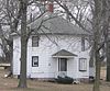 | November 23, 1977 (#77000834) | South of Nebraska City off U.S. Route 73 40°34′18″N 95°48′05″W / 40.571674°N 95.801498°W / 40.571674; -95.801498 (George F. Lee Octagon Houses) | Nebraska City | |
| 11 | Little Nemaha River Bridge | 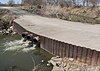 | June 29, 1992 (#92000720) | County road over the Little Nemaha River, 1.8 miles (2.9 km) northwest of Dunbar 40°40′58″N 96°02′43″W / 40.68264°N 96.04517°W / 40.68264; -96.04517 (Little Nemaha River Bridge) | Dunbar | Bridge no longer there; replaced by culvert. |
| 12 | Joachim Massow-Charles and Annie Schutz House |  | August 28, 2012 (#12000567) | 4250 F Rd. 40°42′39″N 96°03′34″W / 40.710704°N 96.059395°W / 40.710704; -96.059395 (Joachim Massow-Charles and Annie Schutz House) | Dunbar | |
| 13 | Mayhew Cabin |  | February 11, 2011 (#11000013) | 2012 4th Corso 40°40′24″N 95°52′12″W / 40.673333°N 95.87003°W / 40.673333; -95.87003 (Mayhew Cabin) | Nebraska City | |
| 14 | Memorial Building |  | March 22, 2016 (#16000106) | 810 1st Corso 40°40′33″N 95°51′20″W / 40.675955°N 95.855570°W / 40.675955; -95.855570 (Memorial Building) | Nebraska City | |
| 15 | Morton-James Public Library |  | May 28, 1976 (#76001134) | 923 First Corso[9] 40°40′32″N 95°51′26″W / 40.675441°N 95.85736°W / 40.675441; -95.85736 (Morton-James Public Library) | Nebraska City | |
| 16 | Nebraska City Burlington Depot |  | August 8, 1997 (#97000881) | Southeast intersection of 6th Street and 7th Corso[10] 40°40′13″N 95°51′09″W / 40.67019°N 95.85256°W / 40.67019; -95.85256 (Nebraska City Burlington Depot) | Nebraska City | |
| 17 | Nebraska City Historic District |  | October 29, 1976 (#76001135) | Roughly bounded by 5th Ave., 3rd St., 19th St., and 1st Corso 40°40′43″N 95°51′30″W / 40.678611°N 95.858333°W / 40.678611; -95.858333 (Nebraska City Historic District) | Nebraska City | |
| 18 | Otoe County Courthouse |  | June 18, 1976 (#76001136) | 10th St. and Central Ave. 40°40′34″N 95°51′30″W / 40.676193°N 95.858264°W / 40.676193; -95.858264 (Otoe County Courthouse) | Nebraska City | |
| 19 | Palmyra Pioneer Cemetery |  | November 8, 2021 (#100007151) | Jct. of Giles and North 10th Rds. 40°41′22″N 96°22′08″W / 40.6895°N 96.3688°W / 40.6895; -96.3688 (Palmyra Pioneer Cemetery) | Palmyra | |
| 20 | St. Benedict's Catholic Church |  | January 27, 1983 (#83001100) | 411 5th Rue 40°40′11″N 95°50′28″W / 40.66972°N 95.84111°W / 40.66972; -95.84111 (St. Benedict's Catholic Church) | Nebraska City | |
| 21 | South 13th Street Historic District |  | October 29, 1976 (#76001137) | Roughly bounded by 12th Street, 14th Street, 1st Corso, and 6th Corso 40°40′24″N 95°51′39″W / 40.673333°N 95.860833°W / 40.673333; -95.860833 (South 13th Street Historic District) | Nebraska City | |
| 22 | South Nebraska City Historic District |  | October 22, 1976 (#76001138) | Roughly bounded by 4th Street, 11th Street, 1st Corso, and 4th Corso 40°40′27″N 95°51′14″W / 40.674167°N 95.853889°W / 40.674167; -95.853889 (South Nebraska City Historic District) | Nebraska City | |
| 23 | U.S. Post Office | 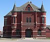 | September 3, 1971 (#71000488) | 202 S. 8th St. 40°40′32″N 95°51′20″W / 40.67547°N 95.85542°W / 40.67547; -95.85542 (U.S. Post Office) | Nebraska City | Now Farmers Bank & Trust Co.[11] |
| 24 | Unadilla Main Street Historic District |  | February 17, 1995 (#95000095) | Northern side of Main St. between G and H Sts. 40°40′54″N 96°16′21″W / 40.68172°N 96.2726°W / 40.68172; -96.2726 (Unadilla Main Street Historic District) | Unadilla | |
| 25 | Jasper A. Ware House |  | July 16, 1973 (#73001070) | 420 Steinhart Park Rd.[12] 40°40′18″N 95°52′50″W / 40.67157°N 95.88064°W / 40.67157; -95.88064 (Jasper A. Ware House) | Nebraska City | Operated as museum under name "Wildwood Historic Center".[12] |
| 26 | Wolf Creek Bridge |  | June 29, 1992 (#92000738) | Vacated county road over Wolf Creek, 10.3 miles (16.6 km) northeast of Dunbar 40°47′03″N 95°54′57″W / 40.78415°N 95.91576°W / 40.78415; -95.91576 (Wolf Creek Bridge) | Dunbar | |
| 27 | Wyoming Bridge |  | June 29, 1992 (#92000736) | County road over Squaw Creek, 9.1 miles (14.6 km) northeast of Dunbar 40°44′43″N 95°53′33″W / 40.745343°N 95.892594°W / 40.745343; -95.892594 (Wyoming Bridge) | Dunbar | Apparently replaced by beam bridge in 2003[13] |
Former listing
| [3] | Name on the Register | Image | Date listed | Date removed | Location | City or town | Description |
|---|---|---|---|---|---|---|---|
| 1 | Little Nemaha River Bridge | Upload image | June 29, 1992 (#92000723) | December 19, 2012 | County road over the Little Nemaha River, 3 miles (4.8 km) northwest of Syracuse 40°40′00″N 96°14′09″W / 40.666667°N 96.235833°W / 40.666667; -96.235833 (Little Nemaha River Bridge) | Syracuse | Severely damaged by flooding in 2010 and subsequently demolished. |
| 2 | McCartney School District 17 |  | November 15, 2000 (#00001379) | March 25, 2019 | 5797 H Road[14] 40°40′57″N 95°55′00″W / 40.682436°N 95.916631°W / 40.682436; -95.916631 (McCartney School District 17) | Nebraska City | Apparently removed or demolished[15] |
See also
Wikimedia Commons has media related to National Register of Historic Places in Otoe County, Nebraska.
- List of National Historic Landmarks in Nebraska
- National Register of Historic Places listings in Nebraska
References
- ^ The latitude and longitude information provided in this table was derived originally from the National Register Information System, which has been found to be fairly accurate for about 99% of listings. Some locations in this table may have been corrected to current GPS standards.
- ^ National Park Service, United States Department of the Interior, "National Register of Historic Places: Weekly List Actions", retrieved June 14, 2024.
- ^ a b Numbers represent an alphabetical ordering by significant words. Various colorings, defined here, differentiate National Historic Landmarks and historic districts from other NRHP buildings, structures, sites or objects.
- ^ The eight-digit number below each date is the number assigned to each location in the National Register Information System database, which can be viewed by clicking the number.
- ^ See photo.
- ^ See photos: this one for Q, this one for the 6903 address (lower right corner).
- ^ "Harmony School". Otoe County Genealogical Society. Retrieved 2012-03-05.
- ^ "Kregel Windmill Museum". Retrieved 2012-04-18.
- ^ "Contact Us". Archived 2013-06-21 at the Wayback Machine Morton-James Public Library. Retrieved 2013-06-15.
- ^ Miller, Greg. "National Register of Historic Places Registration Form: Nebraska City Burlington Depot".[usurped] Nebraska State Historical Society.[usurped] Retrieved 2012-03-05.
- ^ "Farmers Bank & Trust Co." Archived 2012-04-26 at the Wayback Machine Retrieved 2012-04-19.
- ^ a b "Wildwood Historic Center". Retrieved 2012-03-05.
- ^ See June 2013 photos at Commons:Category:Wyoming Creek bridge, CR 60, Otoe County, Nebraska for current bridge. According to uglybridges.com, the current bridge was built in 2003.
- ^ "Mc Cartney Public School". Nebraska Department of Education. Retrieved 2012-03-05.
- ^ See June 2013 photos at Commons:Category:McCartney School District 17 (Otoe County, Nebraska). NRHP nominating form[usurped] lists a single contributing building, a red brick schoolhouse. A basketball hoop and pump visible in photos are mentioned in the form, but no contributing structures or objects are listed. A July 14, 2009 article in the Nebraska City News-Press states that the Nebraska City School Board voted to sell the school.
- v
- t
- e

- Adams
- Antelope
- Arthur
- Banner
- Blaine
- Boone
- Box Butte
- Boyd
- Brown
- Buffalo
- Burt
- Butler
- Cass
- Cedar
- Chase
- Cherry
- Cheyenne
- Clay
- Colfax
- Cuming
- Custer
- Dakota
- Dawes
- Dawson
- Deuel
- Dixon
- Dodge
- Douglas
- Dundy
- Fillmore
- Franklin
- Frontier
- Furnas
- Gage
- Garden
- Garfield
- Gosper
- Grant
- Greeley
- Hall
- Hamilton
- Harlan
- Hayes
- Hitchcock
- Holt
- Hooker
- Howard
- Jefferson
- Johnson
- Kearney
- Keith
- Keya Paha
- Kimball
- Knox
- Lancaster
- Lincoln
- Logan
- Loup
- Madison
- McPherson
- Merrick
- Morrill
- Nance
- Nemaha
- Nuckolls
- Otoe
- Pawnee
- Perkins
- Phelps
- Pierce
- Platte
- Polk
- Red Willow
- Richardson
- Rock
- Saline
- Sarpy
- Saunders
- Scotts Bluff
- Seward
- Sheridan
- Sherman
- Sioux
- Stanton
- Thayer
- Thomas
- Thurston
- Valley
- Washington
- Wayne
- Webster
- Wheeler
- York
- Bridges
- Historic districts
- Houses
- National Historic Landmarks
- Properties of religious function
- Railway stations
 Category
 List
List National Register of Historic Places Portal


Municipalities and communities of Otoe County, Nebraska, United States | ||
|---|---|---|
County seat: Nebraska City | ||
| Cities |  | |
| Villages | ||
| CDP | ||
| Unincorporated communities | ||
| Ghost town | ||
| ||


