National Register of Historic Places listings in Marion County, Florida

This is a list of the National Register of Historic Places listings in Marion County, Florida.
This is intended to be a complete list of the properties and districts on the National Register of Historic Places in Marion County, Florida, United States. The locations of National Register properties and districts for which the latitude and longitude coordinates are included below, may be seen in a map.[1]
There are 33 properties and districts listed on the National Register in the county, including 1 National Historic Landmark.
This National Park Service list is complete through NPS recent listings posted June 14, 2024.[2]
Map all coordinates using OpenStreetMap
Download coordinates as:
- KML
- GPX (all coordinates)
- GPX (primary coordinates)
- GPX (secondary coordinates)
| Alachua - Baker - Bay - Bradford - Brevard - Broward - Calhoun - Charlotte - Citrus - Clay - Collier - Columbia - DeSoto - Dixie - Duval - Escambia - Flagler - Franklin - Gadsden - Gilchrist - Glades - Gulf - Hamilton - Hardee - Hendry - Hernando - Highlands - Hillsborough (Tampa) - Holmes - Indian River - Jackson - Jefferson - Lafayette - Lake - Lee - Leon - Levy - Liberty - Madison - Manatee - Marion - Martin - Miami-Dade (Miami) - Monroe - Nassau - Okaloosa - Okeechobee - Orange - Osceola - Palm Beach - Pasco - Pinellas - Polk - Putnam - St. Johns - St. Lucie - Santa Rosa - Sarasota - Seminole - Sumter - Suwannee - Taylor - Union - Volusia - Wakulla - Walton - Washington |
Current listings
| [3] | Name on the Register[4] | Image | Date listed[5] | Location | City or town | Description |
|---|---|---|---|---|---|---|
| 1 | Armstrong House |  | June 9, 2000 (#00000638) | 18050 U.S. Route 301 North 29°24′44″N 82°06′38″W / 29.412222°N 82.110556°W / 29.412222; -82.110556 (Armstrong House) | Citra | |
| 2 | Alfred Ayer House | 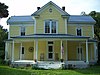 | July 13, 1993 (#93000590) | Alternate U.S. Routes 27/441 west of Oklawaha 29°02′21″N 81°57′00″W / 29.039167°N 81.95°W / 29.039167; -81.95 (Alfred Ayer House) | Ocklawaha | Part of the Early Residences of Rural Marion County MPS |
| 3 | Thomas R. Ayer House |  | July 13, 1993 (#93000588) | 11885 Southeast 128th Place 29°02′09″N 81°57′22″W / 29.035833°N 81.956111°W / 29.035833; -81.956111 (Thomas R. Ayer House) | Ocklawaha | Part of the Early Residences of Rural Marion County MPS |
| 4 | Belleview School |  | March 25, 1999 (#99000372) | 5343 Southeast Abshier Boulevard 29°03′37″N 82°03′35″W / 29.060278°N 82.059722°W / 29.060278; -82.059722 (Belleview School) | Belleview | |
| 5 | Gen. Robert Bullock House |  | July 13, 1993 (#93000589) | Junction of Southeast 119th Court and Southeast 128 Place 29°02′06″N 81°57′15″W / 29.035°N 81.954167°W / 29.035; -81.954167 (Gen. Robert Bullock House) | Ocklawaha | Part of the Early Residences of Rural Marion County MPS |
| 6 | Carr Family Cabin | Upload image | February 28, 2017 (#100000683) | Nicotoon Lake, Ocala NF, FS Tract #C-2233 28°59′56″N 81°42′36″W / 28.998876°N 81.709923°W / 28.998876; -81.709923 (Carr Family Cabin) | Umatilla vicinity | More info here |
| 7 | Citra Methodist Episcopal Church-South | 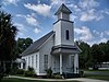 | March 5, 1998 (#98000177) | 2010 Northeast 180th Street 29°24′40″N 82°06′51″W / 29.411111°N 82.114167°W / 29.411111; -82.114167 (Citra Methodist Episcopal Church-South) | Citra | |
| 8 | Coca-Cola Bottling Plant | 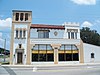 | May 4, 1979 (#79000682) | 939 North Magnolia Avenue 29°11′47″N 82°08′11″W / 29.196389°N 82.136389°W / 29.196389; -82.136389 (Coca-Cola Bottling Plant) | Ocala | |
| 9 | Dunnellon Boomtown Historic District | 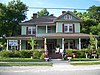 | December 8, 1988 (#88002807) | Roughly bounded by McKinney Avenue, Illinois Street, Pennsylvania Avenue, and Cedar Street 29°03′05″N 82°27′48″W / 29.051389°N 82.463333°W / 29.051389; -82.463333 (Dunnellon Boomtown Historic District) | Dunnellon | |
| 10 | East Hall |  | July 28, 1995 (#95000924) | 307 Southeast 26th Terrace 29°11′03″N 82°06′02″W / 29.184167°N 82.100556°W / 29.184167; -82.100556 (East Hall) | Ocala | |
| 11 | Federal Building, United States Post Office, and Court House |  | September 6, 2022 (#100008120) | 207 NW 2nd St. 29°11′19″N 82°08′20″W / 29.188728°N 82.138989°W / 29.188728; -82.138989 (Federal Building, United States Post Office, and Court House) | Ocala | |
| 12 | Robert W. Ferguson House |  | March 23, 1995 (#95000288) | Off County Road 326, east of its junction with U.S. Route 27 29°17′00″N 82°17′13″W / 29.283333°N 82.286944°W / 29.283333; -82.286944 (Robert W. Ferguson House) | Emathla | Part of the Early Residences of Rural Marion County MPS |
| 13 | Fort King Site |  | February 24, 2004 (#04000320) | Address Restricted 29°11′20″N 82°04′56″W / 29.1889°N 82.0822°W / 29.1889; -82.0822 (Fort King Site) | Ocala | A National Historic Landmark |
| 14 | James Riley Josselyn House |  | July 13, 1993 (#93000591) | 13845 Alternate U.S. Route 27 29°01′20″N 81°54′30″W / 29.022222°N 81.908333°W / 29.022222; -81.908333 (James Riley Josselyn House) | Eastlake Weir | Part of the Early Residences of Rural Marion County MPS |
| 15 | Kerr City Historic District |  | September 29, 1995 (#95001150) | South of County Road 316, north of Lake Kerr 29°22′29″N 81°46′39″W / 29.374722°N 81.7775°W / 29.374722; -81.7775 (Kerr City Historic District) | Fort McCoy | |
| 16 | Lake Lillian Neighborhood Historic District |  | August 20, 1999 (#99001012) | Roughly bounded by Lillian Circle, Southeast Stetson Road, Southeast Mimosa Road, Southeast Earp Road, and the CSX railroad tracks 29°03′44″N 82°03′10″W / 29.062222°N 82.052778°W / 29.062222; -82.052778 (Lake Lillian Neighborhood Historic District) | Belleview | |
| 17 | Lake Weir Yacht Club | 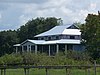 | April 22, 1993 (#93000319) | New York Avenue 29°01′15″N 81°54′50″W / 29.020833°N 81.913889°W / 29.020833; -81.913889 (Lake Weir Yacht Club) | Eastlake Weir | |
| 18 | Marion Hotel |  | October 16, 1980 (#80000955) | 108 North Magnolia Avenue 29°11′16″N 82°08′14″W / 29.187778°N 82.137222°W / 29.187778; -82.137222 (Marion Hotel) | Ocala | |
| 19 | McIntosh Historic District |  | November 18, 1983 (#83003550) | Roughly bounded by the railroad right-of-way, 10th Street, and Avenues C and H 29°26′57″N 82°13′11″W / 29.449167°N 82.219722°W / 29.449167; -82.219722 (McIntosh Historic District) | McIntosh | |
| 20 | Morgan-Townsend House |  | September 26, 2013 (#13000794) | 13535 N. FL 19 29°21′00″N 81°44′03″W / 29.349889°N 81.734054°W / 29.349889; -81.734054 (Morgan-Townsend House) | Salt Springs | |
| 21 | Mount Zion A.M.E. Church |  | December 17, 1979 (#79000683) | 623 South Magnolia Avenue 29°10′52″N 82°08′13″W / 29.181111°N 82.136944°W / 29.181111; -82.136944 (Mount Zion A.M.E. Church) | Ocala | |
| 22 | Ocala Historic Commercial District | 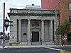 | June 3, 1999 (#99000656) | Roughly bounded by 1st Street NW, 1st Avenue SE, 2nd Street SW, and 1st Avenue SW 29°11′08″N 82°08′12″W / 29.185556°N 82.136667°W / 29.185556; -82.136667 (Ocala Historic Commercial District) | Ocala | |
| 23 | Ocala Historic District |  | January 12, 1984 (#84000912) | Roughly bounded by Broadway, Southeast 8th Street, Silver Springs Place, and Southeast 3rd, 13th, and Watula Avenues 29°11′00″N 82°07′42″W / 29.183333°N 82.128333°W / 29.183333; -82.128333 (Ocala Historic District) | Ocala | |
| 24 | Ocala Union Station |  | December 22, 1997 (#97001557) | 531 Northeast First Avenue 29°11′31″N 82°08′09″W / 29.191944°N 82.135833°W / 29.191944; -82.135833 (Ocala Union Station) | Ocala | |
| 25 | Old Fessenden Academy Historic District |  | September 29, 1994 (#94001141) | 4200 Northwest 90th Street 29°16′52″N 82°11′28″W / 29.281111°N 82.191111°W / 29.281111; -82.191111 (Old Fessenden Academy Historic District) | Ocala | |
| 26 | Orange Springs Methodist Episcopal Church and Cemetery | 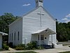 | December 22, 1988 (#88002805) | State Road 315 and Church Street 29°30′09″N 81°56′44″W / 29.5025°N 81.945556°W / 29.5025; -81.945556 (Orange Springs Methodist Episcopal Church and Cemetery) | Orange Springs | |
| 27 | T. W. Randall House |  | April 6, 1995 (#95000289) | 11685 Northeast County Highway C-314 29°13′57″N 81°57′39″W / 29.2325°N 81.960833°W / 29.2325; -81.960833 (T. W. Randall House) | Silver Springs | Part of the Early Residences of Rural Marion County MPS |
| 28 | The Ritz Apartment |  | August 21, 1986 (#86001722) | 1205 East Silver Springs Boulevard 29°11′13″N 82°07′05″W / 29.186944°N 82.118056°W / 29.186944; -82.118056 (The Ritz Apartment) | Ocala | |
| 29 | Silver Springs |  | November 19, 2011 (#100004353) | 5656 East Silver Springs Blvd. 29°13′05″N 82°03′16″W / 29.2181°N 82.0545°W / 29.2181; -82.0545 (Silver Springs) | Silver Springs | |
| 30 | E. C. Smith House |  | May 24, 1990 (#90000806) | 507 Northeast 8th Avenue 29°11′32″N 82°07′47″W / 29.192222°N 82.129722°W / 29.192222; -82.129722 (E. C. Smith House) | Ocala | |
| 31 | James W. Townsend House |  | October 17, 1988 (#88001849) | Main and Spring Streets 29°30′25″N 81°56′39″W / 29.506944°N 81.944167°W / 29.506944; -81.944167 (James W. Townsend House) | Orange Springs | |
| 32 | Tuscawilla Park Historic District |  | March 30, 1988 (#87002015) | Northeast Fourth Street, Sanchez Avenue, Second Street, Tuscawilla Avenue, and Watula Street 29°11′21″N 82°07′57″W / 29.189167°N 82.1325°W / 29.189167; -82.1325 (Tuscawilla Park Historic District) | Ocala | |
| 33 | West Ocala Historic District |  | June 27, 2002 (#02000682) | Roughly Northwest 4th Street, West Silver Springs Boulevard, and Northwest 12th Avenue 29°11′17″N 82°08′47″W / 29.188056°N 82.146389°W / 29.188056; -82.146389 (West Ocala Historic District) | Ocala |
See also
Wikimedia Commons has media related to National Register of Historic Places in Marion County, Florida.
- List of National Historic Landmarks in Florida
- National Register of Historic Places listings in Florida
References
- ^ The latitude and longitude information provided in this table was derived originally from the National Register Information System, which has been found to be fairly accurate for about 99% of listings. Some locations in this table may have been corrected to current GPS standards.
- ^ National Park Service, United States Department of the Interior, "National Register of Historic Places: Weekly List Actions", retrieved June 14, 2024.
- ^ Numbers represent an alphabetical ordering by significant words. Various colorings, defined here, differentiate National Historic Landmarks and historic districts from other NRHP buildings, structures, sites or objects.
- ^ "National Register Information System". National Register of Historic Places. National Park Service. March 13, 2009.
- ^ The eight-digit number below each date is the number assigned to each location in the National Register Information System database, which can be viewed by clicking the number.
- v
- t
- e
by county
- Alachua
- Baker
- Bay
- Bradford
- Brevard
- Broward
- Calhoun
- Charlotte
- Citrus
- Clay
- Collier
- Columbia
- DeSoto
- Dixie
- Duval
- Escambia
- Flagler
- Franklin
- Gadsden
- Gilchrist
- Glades
- Gulf
- Hamilton
- Hardee
- Hendry
- Hernando
- Highlands
- Hillsborough
- Holmes
- Indian River
- Jackson
- Jefferson
- Lake
- Lee
- Leon
- Levy
- Liberty
- Madison
- Manatee
- Marion
- Martin
- Miami-Dade
- Monroe
- Nassau
- Okaloosa
- Okeechobee
- Orange
- Osceola
- Palm Beach
- Pasco
- Pinellas
- Polk
- Putnam
- Santa Rosa
- Sarasota
- Seminole
- St. Johns
- St. Lucie
- Sumter
- Suwannee
- Taylor
- Union
- Volusia
- Wakulla
- Walton
- Washington


