National Register of Historic Places listings in Jackson County, Missouri

This is a list of the National Register of Historic Places listings in Jackson County, Missouri.
This is intended to be a complete list of the properties and districts on the National Register of Historic Places in Jackson County, Missouri, United States. Latitude and longitude coordinates are provided for many National Register properties and districts; these locations may be seen together in a map.[1]
There are 392 properties and districts listed on the National Register in the county, including 4 National Historic Landmarks and 1 National Historic Site. The portion of Kansas City in the county is the location of 341 of these properties and districts; they are listed separately, while the remaining 51 properties and districts, including all of National Historic Landmarks and the National Historic Site, are listed below.
This National Park Service list is complete through NPS recent listings posted June 7, 2024.[2]
Map all coordinates using OpenStreetMap
Download coordinates as:
- KML
- GPX (all coordinates)
- GPX (primary coordinates)
- GPX (secondary coordinates)
Current listings
Listings in Kansas City
Exclusive of Kansas City
| [3] | Name on the Register | Image | Date listed[4] | Location | City or town | Description |
|---|---|---|---|---|---|---|
| 1 | Bailey Family Farm Historic District |  | July 3, 2006 (#06000537) | SW corner of Bailey and Ranson Rds. 38°53′45″N 94°20′29″W / 38.895833°N 94.341389°W / 38.895833; -94.341389 (Bailey Family Farm Historic District) | Lee's Summit | |
| 2 | Bayles Addition Historic District | 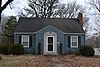 | February 13, 2013 (#13000003) | Bounded by SW. Jefferson, SW. 3rd, SW. 5th, SW. 4th & SW. Walnut Sts. 38°54′36″N 94°22′57″W / 38.909895°N 94.382463°W / 38.909895; -94.382463 (Bayles Addition Historic District) | Lee's Summit | |
| 3 | Bingham-Waggoner House and Estate |  | May 22, 1980 (#80002360) | 313 W. Pacific Ave. 39°05′07″N 94°25′11″W / 39.085278°N 94.419722°W / 39.085278; -94.419722 (Bingham-Waggoner House and Estate) | Independence | |
| 4 | Blue Mills | Upload image | April 21, 1994 (#94000323) | 3101 Lentz Rd. 39°09′28″N 94°18′34″W / 39.157778°N 94.309444°W / 39.157778; -94.309444 (Blue Mills) | Independence | |
| 5 | Dr. John S. Jr. and Harriet Smart Bryant House |  | May 21, 1992 (#92000582) | 519 S. Main St. 39°05′13″N 94°24′56″W / 39.086944°N 94.415556°W / 39.086944; -94.415556 (Dr. John S. Jr. and Harriet Smart Bryant House) | Independence | |
| 6 | Andrew Drumm Institute |  | November 3, 2006 (#06001014) | 3210 Lee's Summit Rd. 39°03′48″N 94°23′38″W / 39.063333°N 94.393889°W / 39.063333; -94.393889 (Andrew Drumm Institute) | Independence | |
| 7 | Fort Osage |  | October 15, 1966 (#66000418) | N edge of Sibley on the Missouri River 39°11′13″N 94°11′31″W / 39.186944°N 94.191944°W / 39.186944; -94.191944 (Fort Osage) | Sibley | |
| 8 | Fort Osage Archeological District | Upload image | March 17, 1972 (#72000720) | Address Restricted | Sibley | |
| 9 | Todd M. George Sr. House | 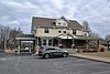 | February 12, 2010 (#10000007) | 408 SE 3rd St. 38°54′51″N 94°22′17″W / 38.914028°N 94.371278°W / 38.914028; -94.371278 (Todd M. George Sr. House) | Lee's Summit | |
| 10 | John and Adele Georgen House |  | May 11, 2000 (#00000486) | 933 S. Main St. 39°04′49″N 94°24′54″W / 39.080278°N 94.415°W / 39.080278; -94.415 (John and Adele Georgen House) | Independence | |
| 11 | German Evangelical Pastors' Home Historic District |  | October 13, 1988 (#88001856) | 1808-1812 W. Walnut and 300-311 19th Terrace 39°00′57″N 94°17′12″W / 39.015833°N 94.286667°W / 39.015833; -94.286667 (German Evangelical Pastors' Home Historic District) | Blue Springs | |
| 12 | Grandview Residential Historic District | Upload image | November 15, 2005 (#05001284) | 807-1111 Highgrove Rd., 13016-13020 and 13019 Grandview Rd. and 13006-13018 10th St. 38°53′24″N 94°31′59″W / 38.89°N 94.533056°W / 38.89; -94.533056 (Grandview Residential Historic District) | Grandview | |
| 13 | Howard Neighborhood Historic District |  | July 3, 2007 (#07000651) | Roughly bounded by SE 5th St., SE Green St., SE 7th St., and SE Miller St. 38°54′31″N 94°22′23″W / 38.908481°N 94.373031°W / 38.908481; -94.373031 (Howard Neighborhood Historic District) | Lee's Summit | |
| 14 | Mollie and Josephine Hughes House |  | April 7, 1994 (#94000289) | 801 S. Main St. 39°05′02″N 94°24′54″W / 39.083889°N 94.415°W / 39.083889; -94.415 (Mollie and Josephine Hughes House) | Independence | |
| 15 | Jackson County Courthouse | 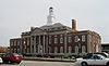 | October 18, 1972 (#72000713) | Bounded by Lexington and Maple Aves. and Liberty and Main Sts. 39°05′33″N 94°24′59″W / 39.092466°N 94.41643°W / 39.092466; -94.41643 (Jackson County Courthouse) | Independence | |
| 16 | Jackson County Jail and Marshal's House | 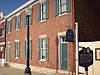 | June 15, 1970 (#70000333) | 217 N. Main St. 39°05′36″N 94°24′55″W / 39.093333°N 94.415278°W / 39.093333; -94.415278 (Jackson County Jail and Marshal's House) | Independence | |
| 17 | Lewis Jones House |  | April 21, 1994 (#94000320) | 104 Elizabeth St. 39°06′22″N 94°24′54″W / 39.106111°N 94.415°W / 39.106111; -94.415 (Lewis Jones House) | Independence | |
| 18 | Lee's Summit Christian Church Building |  | April 20, 2011 (#11000213) | SE Douglas and SE Fourth Sts. 38°54′40″N 94°22′31″W / 38.911111°N 94.375278°W / 38.911111; -94.375278 (Lee's Summit Christian Church Building) | Lee's Summit | |
| 19 | Kritser House |  | April 10, 1985 (#85000734) | 115 E. Walnut 39°05′22″N 94°24′53″W / 39.089444°N 94.414722°W / 39.089444; -94.414722 (Kritser House) | Independence | |
| 20 | Lee's Summit Downtown Historic District |  | August 17, 2005 (#05000889) | Roughly bounded by Second St., Douglas St., Fourth St., and Market St. 38°54′48″N 94°22′36″W / 38.913333°N 94.376667°W / 38.913333; -94.376667 (Lee's Summit Downtown Historic District) | Lee's Summit | |
| 21 | Lee's Summit Post Office | Upload image | August 23, 2018 (#100002426) | 210 SW Market St. 38°54′43″N 94°22′45″W / 38.9119°N 94.3793°W / 38.9119; -94.3793 (Lee's Summit Post Office) | Lee's Summit | |
| 22 | Lewis-Webb House |  | February 6, 1986 (#86000154) | 302 W. Mill 39°06′00″N 94°25′06″W / 39.1°N 94.418333°W / 39.1; -94.418333 (Lewis-Webb House) | Independence | |
| 23 | Longview Farm |  | October 24, 1985 (#85003378) | 11700 and 850 S.W. Longview Rd. 38°54′20″N 94°26′49″W / 38.905556°N 94.446944°W / 38.905556; -94.446944 (Longview Farm) | Lee's Summit | |
| 24 | Charles Minor House |  | March 22, 1984 (#84002573) | 314 N. Spring St. 39°05′40″N 94°25′11″W / 39.094444°N 94.419722°W / 39.094444; -94.419722 (Charles Minor House) | Independence | |
| 25 | Missouri Pacific Depot | 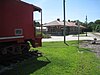 | January 22, 1979 (#79001365) | 600 S. Grand 39°05′12″N 94°25′45″W / 39.086667°N 94.429167°W / 39.086667; -94.429167 (Missouri Pacific Depot) | Independence | |
| 26 | Morningside Acres Historic Ranch House District |  | February 3, 2012 (#11001083) | Roughly 600 block east of Independence Ave. between SE 3rd Terrace & SE 5th St. 38°54′44″N 94°21′56″W / 38.912153°N 94.365442°W / 38.912153; -94.365442 (Morningside Acres Historic Ranch House District) | Lee's Summit | part of the Lee's Summit, Missouri Multiple Property Submission |
| 27 | Mount Washington School |  | April 23, 2013 (#13000192) | 570 S. Evanston Ave. 39°06′13″N 94°27′46″W / 39.103655°N 94.462772°W / 39.103655; -94.462772 (Mount Washington School) | Independence | |
| 28 | Smallwood V. Noland House |  | April 21, 1994 (#94000319) | 1024 S. Forest St. 39°04′54″N 94°26′13″W / 39.081667°N 94.436944°W / 39.081667; -94.436944 (Smallwood V. Noland House) | Independence | |
| 29 | Northeast Douglas Street Residential Historic District |  | August 27, 2008 (#08000803) | NE Douglas St. roughly between Elm and Maggie Sts. 38°55′12″N 94°22′48″W / 38.920075°N 94.380064°W / 38.920075; -94.380064 (Northeast Douglas Street Residential Historic District) | Lee's Summit | |
| 30 | Northeast Forest Avenue and Northeast Green Street Residential Historic District |  | August 27, 2008 (#08000804) | 108, 110, 114 NE Forest Ave. and 310, 312 NE Green St. 38°55′12″N 94°22′40″W / 38.919981°N 94.377678°W / 38.919981; -94.377678 (Northeast Forest Avenue and Northeast Green Street Residential Historic District) | Lee's Summit | |
| 31 | Northeast Green and 1st Streets Residential Historic District |  | August 27, 2008 (#08000805) | Roughly bounded by NE Douglas St., Maple St., 1st St., and NE Johnson St. 38°55′00″N 94°22′37″W / 38.91665°N 94.376831°W / 38.91665; -94.376831 (Northeast Green and 1st Streets Residential Historic District) | Lee's Summit | |
| 32 | Overfelt-Campbell-Johnston House |  | September 5, 1975 (#75001066) | 305 S. Pleasant St. 39°05′23″N 94°25′15″W / 39.089722°N 94.420833°W / 39.089722; -94.420833 (Overfelt-Campbell-Johnston House) | Independence | |
| 33 | Owens-McCoy House | 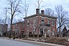 | April 21, 1994 (#94000321) | 410 W. Farmer Ave. 39°05′46″N 94°25′12″W / 39.096111°N 94.42°W / 39.096111; -94.42 (Owens-McCoy House) | Independence | |
| 34 | Rice-Tremonti House |  | March 2, 1979 (#79001376) | 8801 E. 66th St. 39°00′14″N 94°28′54″W / 39.003889°N 94.481667°W / 39.003889; -94.481667 (Rice-Tremonti House) | Raytown | |
| 35 | Saint Paul's Episcopal Church | 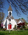 | October 3, 1985 (#85002720) | Fifth and S. Green Sts. 38°54′39″N 94°22′21″W / 38.910833°N 94.3725°W / 38.910833; -94.3725 (Saint Paul's Episcopal Church) | Lee's Summit | |
| 36 | Santa Fe Trail-Santa Fe Trail Park, Independence Trail Segments | Upload image | April 21, 1994 (#94000322) | Santa Fe Rd. 39°03′56″N 94°25′35″W / 39.065556°N 94.426389°W / 39.065556; -94.426389 (Santa Fe Trail-Santa Fe Trail Park, Independence Trail Segments) | Independence | |
| 37 | Sherwood Manufacturing Company Building | 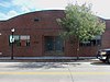 | October 28, 2010 (#10000204) | 123 SE 3rd St. 38°54′46″N 94°22′29″W / 38.912778°N 94.374722°W / 38.912778; -94.374722 (Sherwood Manufacturing Company Building) | Lee's Summit | part of the Lee's Summit, Missouri Multiple Property Submission |
| 38 | Southeast Grand Avenue and Fifth Street Residential Historic District |  | April 20, 2011 (#11000216) | Roughly the east side of SE Grand Ave. between SE 4th St. and SE 5th St. and the north side of SE 5th St. between SE Grand Ave. and SE Howard St. 38°54′38″N 94°22′20″W / 38.910556°N 94.372222°W / 38.910556; -94.372222 (Southeast Grand Avenue and Fifth Street Residential Historic District) | Lee's Summit | part of the Lee's Summit, Missouri Multiple Property Submission |
| 39 | Southeast Green Street Historic Cottage District |  | October 14, 2010 (#10000837) | 311-330, and 400 and 401 SE Green St. 38°54′44″N 94°22′26″W / 38.912222°N 94.373889°W / 38.912222; -94.373889 (Southeast Green Street Historic Cottage District) | Lee's Summit | part of the Lee's Summit, Missouri Multiple Property Submission |
| 40 | Southeast Third Street and Southeast Corder Avenue Ranch House Historic District |  | September 15, 2011 (#11000669) | Roughly the south side of Southeast 3rd. St. east of Independence Ave.; along Southeast Corder Ave. north of Southeast 4th St.; and five lots on the east side of Southeast Corder Ave. south of 4th St. 38°54′43″N 94°22′05″W / 38.911944°N 94.368056°W / 38.911944; -94.368056 (Southeast Third Street and Southeast Corder Avenue Ranch House Historic District) | Lee's Summit | part of the Lee's Summit, Missouri Multiple Property Submission |
| 41 | Southeast Third Street Residential Historic District |  | October 14, 2010 (#10000838) | Roughly the 400 block of SE Third St. between SE Grand and SE Howard Sts. 38°54′50″N 94°22′17″W / 38.913889°N 94.371389°W / 38.913889; -94.371389 (Southeast Third Street Residential Historic District) | Lee's Summit | part of the Lee's Summit, Missouri Multiple Property Submission |
| 42 | Southwest Market Street Historic District |  | February 27, 2013 (#13000038) | 314 through 418 SW Market St. 38°54′34″N 94°22′39″W / 38.909453°N 94.377569°W / 38.909453; -94.377569 (Southwest Market Street Historic District) | Lee's Summit | |
| 43 | Southwest Third and Southwest Madison Historic District |  | February 13, 2013 (#13000004) | 202 through 300 SW. 3rd St. 38°54′40″N 94°22′55″W / 38.911097°N 94.381905°W / 38.911097; -94.381905 (Southwest Third and Southwest Madison Historic District) | Lee's Summit | |
| 44 | Temple Site |  | September 22, 1970 (#70000334) | Lexington Ave. and River Boulevard 39°05′29″N 94°25′31″W / 39.091389°N 94.425278°W / 39.091389; -94.425278 (Temple Site) | Independence | |
| 45 | Trinity Episcopal Church |  | April 27, 1979 (#79001366) | 409 N. Liberty St. 39°05′41″N 94°24′59″W / 39.094722°N 94.416389°W / 39.094722; -94.416389 (Trinity Episcopal Church) | Independence | |
| 46 | Harry S. Truman Historic District |  | November 11, 1971 (#71001066) | N. Delaware St. area 39°05′47″N 94°25′22″W / 39.096389°N 94.422778°W / 39.096389; -94.422778 (Harry S. Truman Historic District) | Independence | |
| 47 | Harry S Truman National Historic Site |  | May 31, 1985 (#85001248) | 219 N. Delaware St.; also 601 and 605 W. Truman Rd. and 216 N. Delaware St. 39°05′36″N 94°25′23″W / 39.093333°N 94.423056°W / 39.093333; -94.423056 (Harry S Truman National Historic Site) | Independence | Second set of addresses represents a boundary increase of February 23, 2005 |
| 48 | Unity School of Christianity Historic District | 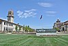 | April 12, 1989 (#89000246) | Junction of US 50 and Colborn Rd. 38°56′49″N 94°24′21″W / 38.946944°N 94.405833°W / 38.946944; -94.405833 (Unity School of Christianity Historic District) | Unity Village | |
| 49 | Harvey M. Vaile Mansion |  | October 1, 1969 (#69000108) | 1500 N. Liberty St. 39°06′29″N 94°25′02″W / 39.108056°N 94.417222°W / 39.108056; -94.417222 (Harvey M. Vaile Mansion) | Independence | |
| 50 | Woodson-Sawyer House |  | March 20, 1986 (#86000457) | 1604 W. Lexington 39°05′14″N 94°26′04″W / 39.087222°N 94.434444°W / 39.087222; -94.434444 (Woodson-Sawyer House) | Independence | |
| 51 | Solomon Young Farm-Harry S. Truman Farm | 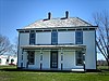 | May 5, 1978 (#78001650) | 12121 and 12301 Blue Ridge Extension 38°54′08″N 94°31′51″W / 38.902222°N 94.530833°W / 38.902222; -94.530833 (Solomon Young Farm-Harry S. Truman Farm) | Grandview |
See also
- List of National Historic Landmarks in Missouri
- National Register of Historic Places listings in Missouri
References
Wikimedia Commons has media related to National Register of Historic Places in Jackson County, Missouri.
- ^ The latitude and longitude information provided in this table was derived originally from the National Register Information System, which has been found to be fairly accurate for about 99% of listings. Some locations in this table may have been corrected to current GPS standards.
- ^ National Park Service, United States Department of the Interior, "National Register of Historic Places: Weekly List Actions", retrieved June 7, 2024.
- ^ Numbers represent an alphabetical ordering by significant words. Various colorings, defined here, differentiate National Historic Landmarks and historic districts from other NRHP buildings, structures, sites or objects.
- ^ The eight-digit number below each date is the number assigned to each location in the National Register Information System database, which can be viewed by clicking the number.
- v
- t
- e
- List of U.S. National Historic Landmarks by state:
- Alabama
- Alaska
- Arizona
- Arkansas
- California
- Colorado
- Connecticut
- Delaware
- Florida
- Georgia
- Hawaii
- Idaho
- Illinois
- Indiana
- Iowa
- Kansas
- Kentucky
- Louisiana
- Maine
- Maryland
- Massachusetts
- Michigan
- Minnesota
- Mississippi
- Missouri
- Montana
- Nebraska
- Nevada
- New Hampshire
- New Jersey
- New Mexico
- New York
- North Carolina
- North Dakota
- Ohio
- Oklahoma
- Oregon
- Pennsylvania
- Rhode Island
- South Carolina
- South Dakota
- Tennessee
- Texas
- Utah
- Vermont
- Virginia
- Washington
- West Virginia
- Wisconsin
- Wyoming
 National Register of Historic Places portal
 Category


Municipalities and communities of Jackson County, Missouri, United States | ||
|---|---|---|
County seats: Independence and Kansas City | ||
| Cities |  | |
| Villages | ||
| Townships | ||
| CDPs | ||
| Other communities | ||
| Footnotes | ‡This populated place also has portions in an adjacent county or counties | |
| ||


