Museum District, Richmond, Virginia
United States historic place
West of Boulevard Historic District | |
Virginia Landmarks Register | |
 | |
37°33′35″N 77°28′46″W / 37.55972°N 77.47944°W / 37.55972; -77.47944 | |
| Area | 249 acres (101 ha) |
|---|---|
| Architect | Multiple |
| Architectural style | Multiple |
| NRHP reference No. | 94000153 [1] |
| VLR No. | 127-0742 |
| Significant dates | |
| Added to NRHP | March 07, 1994 |
| Designated VLR | December 8, 1993[2] |
The Museum District, alternately known as West of the Boulevard,[3] is a neighborhood in the city of Richmond, Virginia. It is anchored by the contiguous six-block tract of museums along the west side of Boulevard, including the Virginia Museum of Fine Arts and the Virginia Museum of History & Culture, hence the name.
It is roughly bounded by the Boulevard (and the Fan District) on the east, I-195 on the west, Monument Avenue and Broad Street on the north, and Carytown on the south. Much of that is listed as a historic district on the National Register of Historic Places.
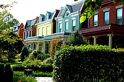
Parts of the area had been in active use as farmland into the late 19th century, and though part was notably used as a Civil War veteran's home at that time, it was primarily developed between 1895 and 1940.[4] It is largely populated with townhouses in styles from the late 19th and early 20th centuries.[4] Though much of the district is residential, there are several schools, religious facilities, and other institutional uses throughout, as well as local restaurants and stores, especially in the "Devil's Triangle" area[4] Carytown generally serves as the shopping district for the area, and in fact the distinction between Carytown and the Museum District is fairly blurry.[5]
The Devil's Triangle is the largest business district in the neighborhood, outside of the streets adjoining Carytown, but there are many small corner stores and restaurants throughout the neighborhood.[6]
References
- ^ "National Register Information System". National Register of Historic Places. National Park Service. March 13, 2009.
- ^ "Virginia Landmarks Register". Virginia Department of Historic Resources. Retrieved March 19, 2013.
- ^ This is the name used in the current Master Plan for the city ("Near West Planning District" (PDF). City Master Plan. City of Richmond Department of Planning and Development Review. Retrieved May 24, 2011.) The National Register uses "West of Boulevard" (sans definite article), while the area neighborhood association uses the "Museum District" as its primary name, though referring to "West of the Boulevard" as well ("Main Website". Museum District Association. Retrieved May 24, 2011.)
- ^ a b c "West of Boulevard National Register Nomination" (PDF). Virginia Department of Historic Resources. Retrieved May 24, 2011.
- ^ "I Love the Museum District". November 14, 2017.
- ^ "The Devil's Triangle".
External links
![]() Media related to Museum District, Richmond, Virginia at Wikimedia Commons
Media related to Museum District, Richmond, Virginia at Wikimedia Commons
- Museum District Civic Association
- Virginia Museum of Fine Arts
- Virginia Museum of History & Culture
Nearby Neighborhoods in Richmond, Virginia | ||||||||||||||||
|---|---|---|---|---|---|---|---|---|---|---|---|---|---|---|---|---|
| ||||||||||||||||


- v
- t
- e
Neighborhoods in Richmond, Virginia
- Arts District
- Banking District
- Biotech and MCV
- Central Office District
- City Center
- Court End
- East Franklin Block
- Financial District
- French Garden Hill
- Gambles Hill
- Jackson Ward
- Monroe Ward
- Riverside District
- Shockoe Bottom
- Shockoe Slip
- Upper Shockoe Valley
- Allen Heights
- Alton Heights
- Ashley Oaks
- Belmont
- Bolton and Taliaferrol
- Bowling Green
- Brauers
- Briels
- Cardinal Court
- Chimborazo
- Chimborazo Village
- Church Hill
- Church Hill North
- Creighton Court
- Eastlawn
- Eastview
- Fairfield
- Fairmount
- Fulton Hill
- Geffert Place
- Glenwood
- Guildts Estates
- Habitat Hills
- Harrison Place
- Howard's Grove
- Kuhn
- Libby Hill
- Linsville
- Mechaniscville Gardens
- Montrose Heights
- Mosby
- Mount Erin
- Montibello
- National Heights
- Navy Hill
- North Church Hill
- Oakwood
- Overhill Place
- Payne Square
- Peter Paul
- Powhatan
- Rainbow Village
- Rico
- Robinson Heights
- Rocketts Landing
- Rutherford Tract
- Shed Town
- Silver Crest
- Tobacco Row
- Tuxedo Park
- Union Hill
- Witcomb Court
- Wynwood
- Battery Court
- Barton Heights
- Bellevue
- Brookland Park
- Chamberlayne Industrial Center
- Chestnut Hill
- Chestnut Hill–Plateau
- Edgewood
- Gilpin
- Ginter Park
- Green Park
- Hermitage Road
- Highland Park
- Highland Terrace
- Laburnum Park
- Magnolia Industrial Center
- North Highland Park
- Pine Camp
- Providence Park
- Rosedale
- Sherwood Park
- Southern Barton Heights
- Virginia Union University
- Washington Park
- Ancarrow's Landing
- Ann's Acres
- Bellemeade
- Belmont Woods
- Blackwell
- Broad Rock
- Brookbury
- Brookside
- Buck Hill
- Cedarhurst
- Cherry Gardens
- Chippenham Forest
- Claremont
- Cofer
- Cotrell Farms
- Dorchester
- Fairway Acres
- Forest Hill
- Gravel Hill
- Hickory Hill
- Hillside Court
- Hioaks
- Holmes Heights
- Huguenot
- Jahnke
- Manchester
- Mason Park
- Maury
- McGuire
- Newell
- Newtown South
- Northrop
- Oak Grove
- Old Town Manchester
- Oxford
- Piney Knolls
- Pocosham Park
- Purcell's Addition
- Robertson & Bradley's Addition
- Saint John's Woods
- South Richmond
- Southampton
- Stratford Hills
- Swansboro
- Thurston & Taylor's Addition
- Warwick
- Westlake Hills
- Westover Court
- Windsor
- Woodhaven
- Woodland Heights
- Woolfolk
- Worthington
- 2900 Block of Grove
- Bays Meade
- Boulevard
- Byrd Park
- Carillon
- Carver
- Carver Industrial
- Carytown
- Chinatown
- Club View
- Colonial Place
- Dahlia Farms
- Duntreath
- The Fan
- Garrett Manor
- Greek Row
- Hampton Gardens
- Hampton Hills
- Harvey
- Henry Place
- Huguenot Farms
- Lee Mac
- Leonard Heights
- Lockgreen
- Malvern Gardens
- Malven Manor
- Mapleshade
- Maymont
- Monument Heights
- Monument Hills
- Museum District
- Nash Plan
- Near West End
- Newtowne West
- Oregon Hill
- Patterson Place
- Portland Place
- Randolph
- Rio Vista
- Rhoadmiller
- Roselawn
- Rothesay
- Sauer's Gardens
- Scott's Addition
- Stonehurst Court
- Stonewall Court
- Sunnyside
- Sydney
- Sydnor's Point
- Texas Beach
- Three Chopt
- Tuckahoe Terrace
- Virginia Commonwealth University
- West Broad Street Commercial Historic District
- West of the Boulevard
- Westhampton
- Willow Lawn
- Wilton
- Windemere
- Windsor Farms
- Windsor Hills


