Mogelsberg

(Learn how and when to remove this message)
Former municipality in St. Gallen, Switzerland
Coat of arms of Mogelsberg
Coat of arms
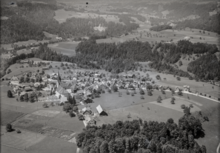
Location of Mogelsberg
Map
47°22′N 9°7′E / 47.367°N 9.117°E / 47.367; 9.117CountrySwitzerlandCantonSt. GallenDistrictToggenburgArea
 • Total3,296 km2 (1,273 sq mi)Elevation
755 m (2,477 ft)Population
 (January 2004)
 • Total2,213 • Density0.67/km2 (1.7/sq mi)Time zoneUTC+01:00 (Central European Time) • Summer (DST)UTC+02:00 (Central European Summer Time)Postal code(s)
9122
SFOS number3406ISO 3166 codeCH-SGSurrounded byBrunnadern, Degersheim, Ganterschwil, Hemberg, Lütisburg, Oberhelfenschwil, Sankt Peterzell, Schwellbrunn (AR)Websitewww.mogelsberg.ch
SFSO statistics

Mogelsberg is a municipality in the Wahlkreis (constituency) of Toggenburg in the canton of St. Gallen in Switzerland.

Mogelsberg was an independent municipality until January 1, 2009, when it merged with Brunnadern and St. Peterzell to form the municipality of Neckertal.[1]

Aerial view (1947)

See also

References

  1. ^ Amtliches Gemeindeverzeichnis der Schweiz published by the Swiss Federal Statistical Office (in German) accessed 14 January 2010

External links

Wikimedia Commons has media related to Mogelsberg.
Authority control databases Edit this at Wikidata
International
  • VIAF
  • WorldCat
National
  • Germany
Other
  • Historical Dictionary of Switzerland


  • v
  • t
  • e