List of Monuments of National Importance in Mumbai circle
This is a list of Monuments of National Importance as officially recognized by the Archaeological Survey of India (ASI) in the Indian state of Maharashtra falling under the jurisdiction of its Mumbai (ASI circle).[1]
| SL. No. | Description | Location | Address | District | Coordinates | Image |
|---|---|---|---|---|---|---|
| N-MH-M1 | Kopeshwar Temple | Khidrapur | Kolhapur |  Upload Photo | ||
| N-MH-M2 | Ancient site at Brahamapuri | Kolhapur | Kolhapur | Upload Photo | ||
| N-MH-M3 | Panhala Fort i. Ambarkhana, ii. Andhra Vav, iii. Dharma Kopthi, iv. Naikinicha Sajja, v. Teen Darwaja, vi. Wagh Darwaja, vii. Tatbandi together with bastions | Panhala | Kolhapur | 16°48′32″N 74°06′33″E / 16.8088889°N 74.1091667°E / 16.8088889; 74.1091667 (SL. No. N-MH-M3) |   | |
| N-MH-M3-a | Panhala Fort: i. Ambarkhana | Panhala | Kolhapur | 16°48′32″N 74°06′33″E / 16.8088889°N 74.1091667°E / 16.8088889; 74.1091667 (SL. No. N-MH-M3-a) | 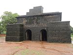 | |
| N-MH-M3-b | Panhala Fort: ii. Andhra Vav | Panhala | Kolhapur | 16°48′32″N 74°06′33″E / 16.8088889°N 74.1091667°E / 16.8088889; 74.1091667 (SL. No. N-MH-M3-b) | Upload Photo | |
| N-MH-M3-c | Panhala Fort: iii. Dharma Kothi | Panhala | Kolhapur | 16°48′32″N 74°06′33″E / 16.8088889°N 74.1091667°E / 16.8088889; 74.1091667 (SL. No. N-MH-M3-c) | Upload Photo | |
| N-MH-M3-d | Panhala Fort: iv. Naikinicha Sajja | Panhala | Kolhapur | 16°48′32″N 74°06′33″E / 16.8088889°N 74.1091667°E / 16.8088889; 74.1091667 (SL. No. N-MH-M3-d) | Upload Photo | |
| N-MH-M3-e | Panhala Fort: v. Teen Darwaja | Panhala | Kolhapur | 16°48′32″N 74°06′33″E / 16.8088889°N 74.1091667°E / 16.8088889; 74.1091667 (SL. No. N-MH-M3-e) |  | |
| N-MH-M3-f | Panhala Fort: vi. Wagh Darwaja | Panhala | Kolhapur | 16°48′32″N 74°06′33″E / 16.8088889°N 74.1091667°E / 16.8088889; 74.1091667 (SL. No. N-MH-M3-f) |  | |
| N-MH-M3-g | Panhala Fort: vii. Tatbandi together with bastions | Panhala | Kolhapur | 16°48′32″N 74°06′33″E / 16.8088889°N 74.1091667°E / 16.8088889; 74.1091667 (SL. No. N-MH-M3-g) | Upload Photo | |
| N-MH-M4 | Buddhist Caves | Pohala | Kolhapur | Upload Photo | ||
| N-MH-M5 | Monolithic bas relief depicting seven manifestations of Siva locally known as Baradeva | Parel village | Mumbai | 19°00′03″N 72°50′43″E / 19.000939°N 72.845321°E / 19.000939; 72.845321 (SL. No. N-MH-M5) | Upload Photo | |
| N-MH-M6 | Whole hill fort of Sion together with all ancient Portuguese remains of buildings situated to the north, east and south-east sides of the hill at its toe | Sion | Mumbai | 19°02′48″N 72°52′03″E / 19.046595°N 72.867498°E / 19.046595; 72.867498 (SL. No. N-MH-M6) |  | |
| N-MH-M7 | The Buddhist Caves | Kaneri | Mumbai Suburban | 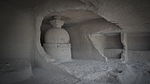 More images | ||
| N-MH-M8 | Caves | Kondiote | Mumbai Suburban | 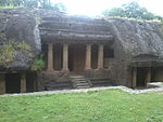 | ||
| N-MH-M9 | Jogeshwari Caves | Majas | Mumbai Suburban | 19°08′21″N 72°51′24″E / 19.1391°N 72.8568°E / 19.1391; 72.8568 (SL. No. N-MH-M9) |  | |
| N-MH-M10 | Old Portuguese Churches, Watch Tower and Caves | Mandapeshwar | Mumbai Suburban |  | ||
| N-MH-M11 | Caves | Mandapeshwar | Mumbai Suburban |  | ||
| N-MH-M12 | The Portuguese monastery over the caves and large watch tower on the adjoining hill at Mandapeshwar | Mandapeshwar | Mumbai Suburban |  | ||
| N-MH-M13 | Fort | Arnala | Palghar | Upload Photo | ||
| N-MH-M14 | Fort and Portuguese remains - Bassein Fort also known as Vasai Fort | Bassein | Palghar | 19°19′49″N 72°48′54″E / 19.33027778°N 72.815°E / 19.33027778; 72.815 (SL. No. N-MH-M14) |  More images | |
| N-MH-M15 | Tank by the west side of the road from Umarale village to Bolinj | Bolinj | Palghar | Upload Photo | ||
| N-MH-M16 | Mound locally known as "Sonar Bhat" in Hissa No.11 of the Survey No. 52 having an area of 25+1⁄4 gunthas | Gas | Palghar | Upload Photo | ||
| N-MH-M17 | Caves on Burud Hill | Khunavada | Palghar | Upload Photo | ||
| N-MH-18 | A mound locally known as Burud Kot in Hissa No.2 of Survey No. 75 having an area of 2 acres and 28+1⁄4 gunthas | Mardes (Nalasopara) | Palghar | Upload Photo | ||
| N-MH-19 | Brahmanical Caves | Polu Sonala | Palghar | Upload Photo | ||
| N-MH-M20 | Carved Stones | Vada | Palghar | Upload Photo | ||
| N-MH-M21 | Small Dargah near Habsi Gumaz (near Junnar) | Agar | Pune | Upload Photo | ||
| N-MH-M22 | Cave Temples and Inscriptions (Bedse Caves) | Bedsa | Pune | 18°44′52″N 73°31′58″E / 18.74770833°N 73.53263889°E / 18.74770833; 73.53263889 (SL. No. N-MH-M22) |  | |
| N-MH-M23 | Cave temples and Inscriptions (Bhaja Caves) | Bhaja | Pune |  | ||
| N-MH-M24 | Caves and inscription at the Nana Pass (Naneghat) | Ghatghar | Pune | 19°18′23″N 73°40′48″E / 19.3064°N 73.6799°E / 19.3064; 73.6799 (SL. No. N-MH-M24) |  | |
| N-MH-M25 | Caves, Temple and Inscription (also known as Lenyadri) | Junnar | Pune | 19°14′34″N 73°53′08″E / 19.24277778°N 73.88555556°E / 19.24277778; 73.88555556 (SL. No. N-MH-M25) |  More images | |
| N-MH-M26 | Fort of Shivneri | Junnar | Pune |  More images | ||
| N-MH-M27 | Habsi Gumbaz | Junnar | Pune |  | ||
| N-MH-M28 | Cave Temples and inscriptions (Karla Caves) | Karla | Pune | 18°47′00″N 73°28′14″E / 18.78333333°N 73.47055556°E / 18.78333333; 73.47055556 (SL. No. N-MH-M28) |  | |
| N-MH-M29 | Ancient dam with lock and sluice gates | Khed | Pune | Upload Photo | ||
| N-MH-M30 | Dilawar Khan's Masjid | Khed | Pune | Upload Photo | ||
| N-MH-M31 | Dilawar Khan's Tomb | Khed | Pune | Upload Photo | ||
| N-MH-M32 | Fort | Lohogad | Pune |  | ||
| N-MH-M33 | Bhuleshwar Mahadeo Temple | Malsiras | Pune | 18°26′09″N 74°14′28″E / 18.435874°N 74.241081°E / 18.435874; 74.241081 (SL. No. N-MH-M33) | 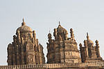 | |
| N-MH-M34 | Aga Khan Palace Building | Pune | Pune | 18°33′08″N 73°54′05″E / 18.5523°N 73.9015°E / 18.5523; 73.9015 (SL. No. N-MH-M34) |  More images | |
| N-MH-M35 | The Cave Temple of Bhamburda (known as Pataleshwar caves) | Pune | Pune |  | ||
| N-MH-M36 | Old Citadel known as Shaniwar Wada | Pune | Pune | 18°31′09″N 73°51′20″E / 18.519075°N 73.85545°E / 18.519075; 73.85545 (SL. No. N-MH-M36) | 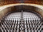 | |
| N-MH-M37 | Old European Tombs | Pune | Pune | Upload Photo | ||
| N-MH-M38 | Fort | Rajmachi | Pune | 18°50′N 73°24′E / 18.83°N 73.4°E / 18.83; 73.4 (SL. No. N-MH-M38) |  | |
| N-MH-M39 | Excavations & Inscriptions (Ghoradeshwar Caves) | Shelarwadi | Pune |  | ||
| N-MH-M40 | Fort | Visapur | Pune | 18°43′21″N 73°29′24″E / 18.7225°N 73.49°E / 18.7225; 73.49 (SL. No. N-MH-M40) | 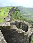 More images | |
| N-MH-M41 | Songad | Achloli | Raigad | Upload Photo | ||
| N-MH-M42 | Cathedral | Agarkot | Raigad | Upload Photo | ||
| N-MH-M43 | Chouburji-the castle or factory of Cheul | Agarkot | Raigad | Upload Photo | ||
| N-MH-M44 | Church & Convent of the Augustinians | Agarkot | Raigad | Upload Photo | ||
| N-MH-M45 | The Dominican Church & Convent | Agarkot | Raigad | Upload Photo | ||
| N-MH-M46 | The Jesuit Monastery | Agarkot | Raigad | Upload Photo | ||
| N-MH-M47 | Kothi | Agarkot | Raigad |  | ||
| N-MH-M48 | 1 Buruj | Agarkot | Raigad |  | ||
| N-MH-M49 | St. Francis Xavier's Chapel | Agarkot | Raigad | Upload Photo | ||
| N-MH-M50 | Satkhani Buruj-St. Barbara's Tower | Agarkot | Raigad | Upload Photo | ||
| N-MH-M51 | Two Gates-Porta do Mar & Porta da Terra | Agarkot | Raigad | Upload Photo | ||
| N-MH-M52 | Hirakote old Fort | Agarkot | Raigad | Upload Photo | ||
| N-MH-M53 | Kolaba Fort Containing i) Sarja Kot, ii) The North Causeway, iii) The Manik Chawda, iv) The South causeway, v) The Talghar, vi) The Padmawati Shrine, vii) The Temple of Gulbai or Mahishasuri, viii) The Shrine of Bhawani, ix) The Nanisahib's Palace, x) The Thorla wada, xi) The Reservoir Apsaras, xii) The Temple of Ganpati-Panchyatan, xiii) The Temple of Mahadeo, xiv) The Shrine of Maruti, xv) The Temple of Kanoba, xvi) The Shrine of Yeshvantdari, xvii) The Tomb of a Mahomedan saint, xviii) The Temple of Bapdeo | Agarkot | Raigad | 18°38′04″N 72°51′51″E / 18.6344°N 72.8642°E / 18.6344; 72.8642 (SL. No. N-MH-M53) |  | |
| N-MH-M53-a | Kolaba Fort: i) Sarja Kot | Agarkot | Raigad | 18°38′04″N 72°51′51″E / 18.6344°N 72.8642°E / 18.6344; 72.8642 (SL. No. N-MH-M53-a) | Upload Photo | |
| N-MH-M53-b | Kolaba Fort Containing: ii) The North Causeway | Agarkot | Raigad | 18°38′04″N 72°51′51″E / 18.6344°N 72.8642°E / 18.6344; 72.8642 (SL. No. N-MH-M53-b) |  | |
| N-MH-M53-c | Kolaba Fort: iii) The Manik Chawda | Agarkot | Raigad | 18°38′04″N 72°51′51″E / 18.6344°N 72.8642°E / 18.6344; 72.8642 (SL. No. N-MH-M53-c) | Upload Photo | |
| N-MH-M53-d | Kolaba Fort: iv) The South causeway | Agarkot | Raigad | 18°38′04″N 72°51′51″E / 18.6344°N 72.8642°E / 18.6344; 72.8642 (SL. No. N-MH-M53-d) | Upload Photo | |
| N-MH-M53-e | Kolaba Fort: v) The Talghar | Agarkot | Raigad | 18°38′04″N 72°51′51″E / 18.6344°N 72.8642°E / 18.6344; 72.8642 (SL. No. N-MH-M53-e) | Upload Photo | |
| N-MH-M53-f | Kolaba Fort: vi) The Padmawati Shrine | Agarkot | Raigad | 18°38′04″N 72°51′51″E / 18.6344°N 72.8642°E / 18.6344; 72.8642 (SL. No. N-MH-M53-f) | Upload Photo | |
| N-MH-M53-g | Kolaba Fort: vii) The Temple of Gulbai or Mahishasuri | Agarkot | Raigad | 18°38′04″N 72°51′51″E / 18.6344°N 72.8642°E / 18.6344; 72.8642 (SL. No. N-MH-M53-g) | Upload Photo | |
| N-MH-M53-h | Kolaba Fort: viii) The Shrine of Bhawani | Agarkot | Raigad | 18°38′04″N 72°51′51″E / 18.6344°N 72.8642°E / 18.6344; 72.8642 (SL. No. N-MH-M53-h) | Upload Photo | |
| N-MH-M53-i | Kolaba Fort: ix) The Nanisahib's Palace | Agarkot | Raigad | 18°38′04″N 72°51′51″E / 18.6344°N 72.8642°E / 18.6344; 72.8642 (SL. No. N-MH-M53-i) | Upload Photo | |
| N-MH-M53-j | Kolaba Fort: x) The Thorla wada | Agarkot | Raigad | 18°38′04″N 72°51′51″E / 18.6344°N 72.8642°E / 18.6344; 72.8642 (SL. No. N-MH-M53-j) | Upload Photo | |
| N-MH-M53-k | Kolaba Fort: xi) The Reservoir Apsaras | Agarkot | Raigad | 18°38′04″N 72°51′51″E / 18.6344°N 72.8642°E / 18.6344; 72.8642 (SL. No. N-MH-M53-k) | Upload Photo | |
| N-MH-M53-l | Kolaba Fort: xii) The Temple of Ganpati-Panchyatan | Agarkot | Raigad | 18°38′04″N 72°51′51″E / 18.6344°N 72.8642°E / 18.6344; 72.8642 (SL. No. N-MH-M53-l) | Upload Photo | |
| N-MH-M53-m | Kolaba Fort: xiii) The Temple of Mahadeo | Agarkot | Raigad | 18°38′04″N 72°51′51″E / 18.6344°N 72.8642°E / 18.6344; 72.8642 (SL. No. N-MH-M53-m) | Upload Photo | |
| N-MH-M53-n | Kolaba Fort: xiv) The Shrine of Maruti | Agarkot | Raigad | 18°38′04″N 72°51′51″E / 18.6344°N 72.8642°E / 18.6344; 72.8642 (SL. No. N-MH-M53-n) | Upload Photo | |
| N-MH-M53-o | Kolaba Fort: xv) The Temple of Kanoba | Agarkot | Raigad | 18°38′04″N 72°51′51″E / 18.6344°N 72.8642°E / 18.6344; 72.8642 (SL. No. N-MH-M53-o) | Upload Photo | |
| N-MH-M53-p | Kolaba Fort: xvi) The Shrine of Yeshvantdari | Agarkot | Raigad | 18°38′04″N 72°51′51″E / 18.6344°N 72.8642°E / 18.6344; 72.8642 (SL. No. N-MH-M53-p) | Upload Photo | |
| N-MH-M53-q | Kolaba Fort: xvii) The Tomb of a Mahomedan saint | Agarkot | Raigad | 18°38′04″N 72°51′51″E / 18.6344°N 72.8642°E / 18.6344; 72.8642 (SL. No. N-MH-M53-q) | Upload Photo | |
| N-MH-M53-r | Kolaba Fort: xviii) The Temple of Bapdeo | Agarkot | Raigad | 18°38′04″N 72°51′51″E / 18.6344°N 72.8642°E / 18.6344; 72.8642 (SL. No. N-MH-M53-r) | Upload Photo | |
| N-MH-M54 | Caves | Ambivli | Raigad | Upload Photo | ||
| N-MH-M55 | Birwadi fort on a broken range of varying 1700 to 900 feet in height | Birwadi | Raigad | Upload Photo | ||
| N-MH-M56 | Barber's Mahal | Cheul | Raigad | Upload Photo | ||
| N-MH-M57 | Dadar (Stair Case) | Cheul | Raigad | Upload Photo | ||
| N-MH-M58 | Kaman (Arch) | Cheul | Raigad | Upload Photo | ||
| N-MH-M59 | Mosque | Cheul | Raigad | Upload Photo | ||
| N-MH-M60 | Rajkot | Cheul | Raigad | Upload Photo | ||
| N-MH-M61 | Tomb of Angre | Cheul | Raigad | Upload Photo | ||
| N-MH-M62 | Vada of Dancing Girls | Cheul | Raigad | Upload Photo | ||
| N-MH-M63 | Chandragad | Dhavala | Raigad | Upload Photo | ||
| N-MH-M64 | Elephanta Caves | Gharapuri | Raigad | 18°57′30″N 72°55′50″E / 18.95833333°N 72.93055556°E / 18.95833333; 72.93055556 (SL. No. N-MH-M64) |  More images | |
| N-MH-M65 | Ancient Brick stupa at Elephanta Island. | Gharapuri | Raigad | 18°57′36″N 72°56′06″E / 18.96°N 72.935°E / 18.96; 72.935 (SL. No. N-MH-M65) | Upload Photo | |
| N-MH-M66 | Gheragad or Surgad | Ghera Surgad | Raigad |  | ||
| N-MH-M67 | Ghosalgad Fort | Ghosale | Raigad |  | ||
| N-MH-M68 | Buddhist Caves | Gomashi | Raigad | Upload Photo | ||
| N-MH-M69 | Old Fort containing a temple of the God Kangormel & Two tanks | Kadasari Kangori | Raigad | Upload Photo | ||
| N-MH-M70 | A precipitious hill near Raigad Fort containing one rock-cut cistern of water. It was formerly used as a Jail for prisoners. | Kadasari Lingana | Raigad | Upload Photo | ||
| N-MH-M71 | Caves | Kol | Raigad | Upload Photo | ||
| N-MH-M72 | Caves situated in Survey No.86 & No. 49 of the Village of Kol | Kol | Raigad | Upload Photo | ||
| N-MH-M73 | Caves | Kondhane | Raigad | 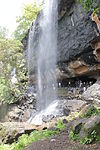 | ||
| N-MH-M74 | Old Fort | Korlai | Raigad | Upload Photo | ||
| N-MH-M75 | Caves | Kuda | Raigad | Upload Photo | ||
| N-MH-M76 | Awchitgad | Medhe | Raigad |  | ||
| N-MH-M77 | Kasa (Kamsa) Fort also known as Murud Fort | Murud | Raigad |  | ||
| N-MH-M78 | Thanala Caves | Nadsur | Raigad | Upload Photo | ||
| N-MH-M79 | Nagothana Bridge | Nagothana | Raigad | Upload Photo | ||
| N-MH-M80 | Khadsamla Caves | Nenawali | Raigad | Upload Photo | ||
| N-MH-M81 | Jijamata's Samadhi consisting of four towers. | Pachad | Raigad | 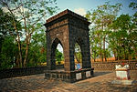 | ||
| N-MH-M82 | Jijamata's Wada comprising four dilapidated houses & three wells surrounded by a stone wall | Pachad | Raigad | Upload Photo | ||
| N-MH-M84 | Caves | Pala | Raigad | Upload Photo | ||
| N-MH-M84 | Caves Near the Kotali Fort | Peth | Raigad |  | ||
| N-MH-M85 | Kotali Fort with two iron guns and one bronze gun | Peth | Raigad |  | ||
| N-MH-M86 | Raigad Fort | Raigad | Raigad | 18°14′01″N 73°26′26″E / 18.2335°N 73.4406°E / 18.2335; 73.4406 (SL. No. N-MH-M86) | 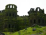 More images | |
| N-MH-M87 | Janjira Fort | Rajapuri | Raigad |  More images | ||
| N-MH-M88 | Tombs at Khokari Najik Ghumaj (Khokari Ghumaj) | Rajapuri | Raigad |  | ||
| N-MH-M89 | Tala Fort | Tala | Raigad | Upload Photo | ||
| N-MH-M90 | Mosque | Dabhol | Ratnagiri | Upload Photo | ||
| N-MH-M91 | Rock cut Caves (Ganesh lena group) | Dapoli | Ratnagiri |  | ||
| N-MH-M92 | Suvarnadurg | Harnai | Ratnagiri | 17°49′01″N 73°05′06″E / 17.817°N 73.085°E / 17.817; 73.085 (SL. No. N-MH-M92) | 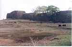 | |
| N-MH-M93 | Jaygad fort | Jaygad | Ratnagiri | 17°18′03″N 73°13′17″E / 17.3007°N 73.2215°E / 17.3007; 73.2215 (SL. No. N-MH-M93) |  | |
| N-MH-M94 | Vijaydurg Fort | Vijaydurg | Ratnagiri |  | ||
| N-MH-M95 | Muhammad Tughlak's Mosque | Khanapur | Sangli | Upload Photo | ||
| N-MH-M96 | Buddhist caves | Jakhinwadi | Satara | Upload Photo | ||
| N-MH-M97 | Panta's Kot or Got open space | Karad | Satara | 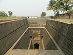 | ||
| N-MH-M98 | Old Temple of the River Krishna facing the Wai Valley | Old Mahabaleshwar | Satara |  | ||
| N-MH-M99 | Jhabareshwar Mahadeo temple | Phaltan | Satara | Upload Photo | ||
| N-MH-M100 | Tomb of Begami | Ghodeshwar | Sholapur | Upload Photo | ||
| N-MH-M101 | Aurangazeb's Fort | Machnur | Sholapur | Upload Photo | ||
| N-MH-M102 | Old Temple of Sri Siddeshwar (enclosed in a paved court) | Machnur | Sholapur | Upload Photo | ||
| N-MH-M103 | Covered colonnade (to the south of the well) | Mahalung | Sholapur | Upload Photo | ||
| N-MH-M104 | Hemadpanthi Temple of Mahadeo | Mahalung | Sholapur | Upload Photo | ||
| N-MH-M105 | Hemadpanthi Temple of Vithoba | Mahalung | Sholapur | Upload Photo | ||
| N-MH-M106 | Hemadpanthi Well | Mahalung | Sholapur | Upload Photo | ||
| N-MH-M107 | Mahadev Stones | Mahalung | Sholapur | Upload Photo | ||
| N-MH-M108 | Temple of Devi (Yamai) | Mahalung | Sholapur | Upload Photo | ||
| N-MH-M109 | Old Fort | Sholapur | Sholapur |  | ||
| N-MH-M110 | Gateway and old Maruti temple with Viragal stones on either side. | Velapur | Sholapur | Upload Photo | ||
| N-MH-M111 | Old doubled shrined temple, on the far side of a tank near the last | Velapur | Sholapur | Upload Photo | ||
| N-MH-M112 | Old Temple and Viragals or sculptured memorial stones by the road side just outside the village | Velapur | Sholapur | Upload Photo | ||
| N-MH-M113 | Old Temple of Sarkarvada locally known as Parasnath temple | Velapur | Sholapur | Upload Photo | ||
| N-MH-M114 | Temple of Haranareshwar & Ardhanarinateshwar, one Hemadpanthi tank (small square kunda) & Viragal stone kept in the compound. | Velapur | Sholapur | Upload Photo | ||
| N-MH-M115 | Sindhudurg Fort | Malvan | Sindhdurg |  | ||
| N-MH-M116 | Temple of Ambarnath | Ambarnath | Thane |  More images | ||
| N-MH-M117 | Mahuli Fort | Mahuli | Thane |  |
See also
- List of State Protected Monuments in Maharashtra
- List of Monuments of National Importance in India
- Heritage structures in Mumbai
References
- ^ "List of Centrally Protected Monuments / Sites under the jurisdiction of Maharashtra (Aurangabad Circle, Mumbai Circle and Nagpur Circle)" (PDF). Archaeological Survey of India. August 2021. Retrieved 27 November 2022.
External links
- v
- t
- e
Monuments in India
Importance
Protected
| States | |
|---|---|
| Union territories |


