Kresson, Baltimore
Neighborhood of Baltimore in Maryland, United States
Kresson | |
|---|---|
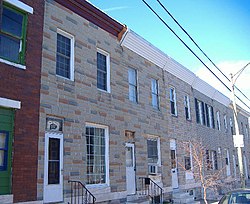 Rowhouses on South Kresson Street | |
| Country | United States |
| State | Maryland |
| City | Baltimore |
| Time zone | UTC-5 (Eastern) |
| • Summer (DST) | EDT |
| ZIP code | 21224 |
| Area code | 410, 443, and 667 |
Kresson is a neighborhood of Southeast Baltimore, Maryland, United States.[1]
The area currently known as Kresson is primarily an industrial district, though a small section contains a residential neighborhood. Residents of Kresson often refer to their neighborhood as Highlandtown, a larger, adjacent residential neighborhood. Kresson's boundaries are defined by Pulaski Highway (U.S. Route 40) to the north, East Lombard and East Pratt Streets to the south, Haven Street (north and south portions) to the west and rail tracks to the east.[2]
The residential neighborhood in Kresson is architecturally, like much of Baltimore, composed of rowhouses. These row houses were constructed around the year 1900. The 2000 census determined its residents to be racially diverse, though predominantly lower-income. The neighborhood of 395 people was 75.9% white, and 20.3% African American.[3]
Kresson Street, which runs through the heart of the Kresson neighborhood, from East Lombard Street to East Monument Street (0.1 miles outside Kresson) is a section of MD 150.[4]
The north-south streets are arranged in consecutive order alphabetically, so to the west of Kresson lie Baylis, Conkling, Dean, Eaton, Fagley, Grundy, Haven, Iris and Janney, while those to the east are named Lehigh, Macon, Newkirk, Oldham, Ponca, Quail, Rappolla, Savage, Tolna and Umbra.
References
- ^ "Baltimore Neighborhoods - Southeast Planning District". Baltimore City Government. Archived from the original on 2007-02-16. Retrieved 2007-08-02.
- ^ "Baltimore Neighborhood Map" (PDF). Live Baltimore Home Center, Inc. June 2005. Archived from the original (PDF) on 2007-09-27. Retrieved 2007-08-02.
- ^ Baltimore City Department of Planning. "Table DP-1. Profile of General Demographic Characteristics: 2000, Neighborhood Statistical Area: KRESSON" (PDF). Baltimore Neighborhood Indicators Alliance. Archived from the original (PDF) on February 13, 2006. Retrieved 2007-08-02.
- ^ Pruett, Mike. "MDRoads: Routes 140-159". Mike Pruett. Retrieved 2007-08-02.
External links
- Baltimore City Police crime map
39°17′45″N 76°33′29″W / 39.29583°N 76.55806°W / 39.29583; -76.55806
- v
- t
- e
- Abell
- Barclay
- Bellona-Gittings
- Better Waverly
- Cameron Village
- Charles Village
- Cedarcroft
- Chinquapin Park-Belvedere
- Cold Spring
- Cylburn
- Edgecomb
- Evergreen
- Glen Oaks
- Govans
- Guilford
- Hampden
- Harwood
- Hoes Heights
- Homeland
- Homewood
- Keswick
- Koreatown
- Lake Evesham
- Lake Walker
- Loyola-Notre Dame
- Medfield
- Mount Washington
- Oakenshawe
- The Orchards
- Pen Lucy
- Poplar Hill
- Radnor-Winston
- Remington
- Roland Park
- Sabina Mattefeldt
- Stone Hill
- Tuscany-Canterbury
- Village of Cross Keys
- Waverly
- Woodberry
- Wyman Park
- Wyndhurst
- Belair-Edison
- Beverly Hills
- Cedonia
- Coldstream-Homestead-Montebello
- Ednor Gardens-Lakeside
- Frankford
- Gardenville
- Govans
- Hamilton Hills
- Hillen
- Lauraville
- Loch Raven
- Mayfield
- Mid-Govans
- Morgan Park
- Northwood
- Overlea
- Ramblewood
- Stonewood-Pentwood-Winston
- Taylor Heights
- Waltherson
- Wilson Park
- Woodbourne Heights
- Barclay
- Berea
- Broadway East
- Coldstream-Homestead-Montebello
- East Baltimore Midway
- East Monument
- Ellwood Park
- Four By Four
- Greenmount West
- Johnston Square
- Latrobe Homes
- Madison-Eastend
- McElderry Park
- Middle East
- Milton-Montford
- Old Town
- Oliver
- Orangeville
- Patterson Park
- South Clifton Park
- Beechfield
- Carrollton Ridge
- Dickeyville
- Franklintown
- Gwynn's Falls
- Hollins Market
- Irvington
- Morrell Park
- Oaklee
- Pigtown
- Saint Agnes
- Sowebo
- Ten Hills
- Union Square
- Violetville
- Wakefield
- Washington Village
- Yale Heights
- Allendale
- Armistead Gardens
- Bel Park Towers
- Claremont
- Douglass Homes
- Ellerslie Homes
- Flaghouse Homes
- Govans Manor Homes
- Heritage Crossing
- Lafayette Court
- Latrobe Homes
- Mason Homes
- Lakeview Towers
- McCulloh Homes
- O'Donnell Heights
- Perkins Homes
- Pleasent View Gardens
- Poe Homes
- Primrose Place
- Somerset Courts
- Carroll Park
- Clifton Park
- Cylburn Arboretum
- Druid Hill Park
- Federal Hill Park
- Fort McHenry
- Gwynns Falls Park
- Hanlon Park
- Herring Run Park
- Lake Roland Park
- Middle Branch Park
- Mount Pleasant Woods Park
- Leakin Park
- Patterson Park
- Riverside Park
- Sherwood Gardens
- Wyman Park


