Houesville
Part of Carentan-les-Marais in Normandy, France
Location of Houesville

49°21′06″N 1°17′11″W / 49.3517°N 1.2864°W / 49.3517; -1.2864
1
(2019)[1]
50480
(avg. 5 m or 16 ft)
Houesville (French pronunciation: [wɛvil]) is a former commune in the Manche department in north-western France. On 1 January 2016, it was merged into the new commune of Carentan-les-Marais.[2]
Heraldry
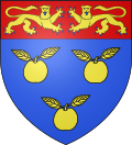 | The arms of Houesville are blazoned : Azure, 3 apples slipped and leaved Or, on a chief gules, 2 leopards respectant Or, armed and langued azure.
|
See also
Wikimedia Commons has media related to Houesville.
References
| Authority control databases: National |
|
|---|
- v
- t
- e


