Hoài Đức district
District in Red River Delta, Vietnam
Hoài Đức district Huyện Hoài Đức | |
|---|---|
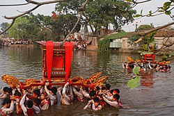 Procession of Saints through the village pond | |
 | |
21°04′11″N 105°42′28″E / 21.069854°N 105.707735°E / 21.069854; 105.707735 | |
| Country |  Vietnam Vietnam |
| Region | Red River Delta |
| Municipality | Hanoi |
| Capital | Trạm Trôi |
| Area | |
| • Total | 3,279 sq mi (8,493 km2) |
| Population (December 31, 2020) | |
| • Total | 276.070 |
| • Density | 8.42/sq mi (3.250/km2) |
| Time zone | UTC+7 (Indochina Time) |
| Website | hoaiduc |
Hoài Đức is a rural district (huyện) of Hanoi in the Red River Delta region of Vietnam.
Geography
Hoài Đức district is bordered by the urban districts of Bắc Từ Liêm and Nam Từ Liêm to the east, the districts of Quốc Oai and Phúc Thọ to the west, Hà Đông district to the south and Đan Phượng district to the north.
Divisions
The is subdivided to 20 commune-level subdivisions, including the township of Trạm Trôi (district capital) and the rural communes of: An Khánh, An Thượng, Cát Quế, Di Trạch, Dương Liễu, Đắc Sở, Đông La, Đức Giang, Đức Thượng, Kim Chung, La Phù, Lại Yên, Minh Khai, Song Phương, Sơn Đồng, Tiền Yên, Vân Canh, Vân Côn, Yên Sở.

Districts of the Red River Delta | ||
|---|---|---|
| Hanoi city |
|  |
| Haiphong city | ||
| Bắc Ninh province | ||
| Hà Nam province | ||
| Hải Dương province |
| |
| Hưng Yên province | ||
| Nam Định province | ||
| Ninh Bình province | ||
| Thái Bình province | ||
| Vĩnh Phúc province |
| |
※ denotes provincial seat. | ||


