Goat Rocks Wilderness
Protected area
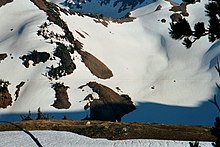
46°30′44″N 121°27′14″W / 46.51222°N 121.45389°W / 46.51222; -121.45389Goat Rocks Wilderness is a U.S. wilderness area in Washington, United States, comprising 108,096 acres (43,745 ha) of Okanagan–Wenatchee National Forest and Gifford Pinchot National Forest on the crest of the Cascade Range south of U.S. Highway 12. Its central feature is a number of rugged peaks, the Goat Rocks, that are named after the numerous mountain goats that live in the area.[2]
Extinct for some two million years, a volcano with an elevation of 12,000 feet (3,700 m) once dominated this landscape. The eroded remnant of this volcano consists of rugged peaks that average over 7,000 feet (2,100 m) elevation. The highest point among them is Gilbert Peak, at 8,184 feet (2,494 m) with a prominence of 3,664 feet (1,117 m). On the shaded northern slopes of the major peaks are the Packwood, McCall, Conrad, and Meade glaciers. The wilderness is drained by the North and South Forks of the Tieton, Cispus, and Cowlitz rivers and their tributaries. The lowest point in the wilderness is near Packwood Lake at 2,920 feet (890 m).
 |
 |
History
The wilderness values of this area were first recognized on February 13, 1931, when approximately 44,500 acres (180 km2) were dedicated by the U.S. Department of Agriculture, Forest Service, as the Goat Rocks Primitive Area. In 1935, this was expanded to 72,440 acres (293 km2). In 1940, the area was increased to 82,680 acres (335 km2) and designated the Goat Rocks Wild Area by the Chief of the Forest Service. When Congress passed the Wilderness Act on September 3, 1964, this wild area became a wilderness, part of the National Wilderness Preservation System. Congress added additional area in 1984. Forest Service management is designated to preserve and enhance the wild character of the Wilderness while providing for public use and enjoyment.[3]
Recreation

The Pacific Crest Trail (PCT), stretching from Canada to Mexico, passes through the Goat Rocks. The Washington State portion of this trail was formerly known as the Washington Cascade Crest Trail completed in 1935. In 1968, it was designated as part of the PCT by the National Trail System Act. The Yakama Indian Reservation, bordering the Goat rocks Wilderness on the southeast side, is closed to the general public except for the Pacific Crest Trail route.[3]
References
![]() This article incorporates public domain material from websites or documents of the United States Fish and Wildlife Service.
This article incorporates public domain material from websites or documents of the United States Fish and Wildlife Service.
- ^ "Goat Rocks Wilderness". Wilderness.net. University of Montana. Retrieved March 26, 2015.
- ^ "Wilderness: Goat Rocks - Gifford Pinchot". Gifford Pinchot National Forest. U.S. Forest Service. Retrieved March 26, 2015.
- ^ a b "Goat Rocks Wilderness". Gifford Pinchot National Forest. U.S. Forest Service. Retrieved March 26, 2015.
External links
Wikimedia Commons has media related to Goat Rocks Wilderness.
- Goat Rocks Wilderness U.S. Forest Service
- Goat Rocks Wilderness Wilderness.net (The University of Montana)
- v
- t
- e
Protected areas of Washington
| Former state parks |
|---|
- Marine protected areas
- Blanchard Forest
- Cascadia Marine Trail
- The Enchantments
- Goose Island
- Les Hilde Trail & Trailheads
- Little Pend Oreille
- Maritime Washington National Heritage Area
- Mount Adams Recreation Area
- Sehome Hill Arboretum
- Walker Valley ORV Riding Area
- Withrow Moraine
- Yellow Island

| Authority control databases |
|
|---|


