Fergana Oblast
Oblast of the Russian Empire (1876–1917)
Oblast in Turkestan, Russian Empire
Fergana Oblast Ферганская область | |
|---|---|
 Coat of arms | |
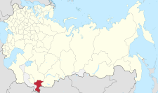 Location in the Russian Empire as of 1914 | |
| Country | Russian Empire |
| Governorate-General | Turkestan |
| Established | 1876 |
| Abolished | 1917 |
| Capital | Skobelev (modern-day Fergana) |
| Area | |
| • Total | 160,141 km2 (61,831 sq mi) |
| Population (1897) | |
| • Total | 1,572,214 |
| • Density | 9.8/km2 (25/sq mi) |
The Fergana Oblast[a] was an oblast (province) of the Russian Empire. It roughly corresponded to most of present-day Fergana Valley. It was created in 1876 when the territories of the former Khanate of Kokand were annexed to Russia (except for the oblasts of Syr-Darya Oblast and Semirechye Oblast, which were part of the khanate before Russian conquest between 1853 and 1865). Its administrative center was the city of Skobelev (which is in modern-day Fergana).
The Oblast was disbanded after the Russian Revolution and on April 30, 1918 the region became a part of the Turkestan ASSR.
Administrative division
As of 1897, the Fergana Oblast was divided into 5 uyezds:
| Uyezd | Uyezd city (pop.) | Area, versta2 | Population[1] |
|---|---|---|---|
| Margelan | Novy Margelan (8,928) | 14,069.1 | 321,860 |
| Andizhan | Andizhan (47,627) | 13,333.2 | 360,267 |
| Kokand | Kokand (81,354) | 13,212.6 | 364,658 |
| Namangan | Namangan (62,017) | 15,273.4 | 363,789 |
| Osh | Osh (34,157) | 65,252.7 | 161,640 |
Demographics
As of 1897, 1,572,214 people populated the oblast. Turkified Sarts (a name used for Tajiks) constituted the majority of the population. Significant minorities included Kyrgyz and Tajiks. The total Turkic-speaking population numbered 1,439,989 (91.6% of the total population of the oblast).
Ethnic groups in 1897
| Group[2] | Number | Percentage |
|---|---|---|
| Sarts | 788,989 | 50.2% |
| Unspecified Turkic dialects | 261,234 | 16.6% |
| Kyrgyz | 201,579 | 12.8% |
| Uzbeks | 153,780 | 9.8% |
| Tajiks | 114,081 | 7.3% |
| Uyghurs | 14,915 | 0.9% |
| Karakalpaks | 11,056 | 0.7% |
| Russians | 8,140 | 0.5% |
| Kipchak | 7,584 | 0.5% |
| Jews | 1,378 | ... |
| TOTAL | 1,572,214 | 100% |
Notes
References
- v
- t
- e
(List)
- Azov¹
- *Altai²
- Arkhangelsk
- Archangelgorod
- Astrakhan
- Belgorod
- Bessarabia
- Bratslav
- Belarus
- Caucasus
- Chernigov
- Grodno
- Finland
- Iziaslav
- Ingermanland
- Irkutsk
- Kazan
- Kaluga
- Kiev (1708)
- Kiev
- Kharkov
- Kherson
- Kholm
- Kovno
- Kolyvan
- Kostroma
- Kursk
- Lithuania
- Little Russia (1764)
- Little Russia (1796)
- Minsk
- Mogilev
- Moscow
- Nikolayev
- Nizhny Novgorod
- Novgorod-Seversky
- Novgorod
- Novorossiya
- Olonets
- Orenburg
- Oryol
- Penza
- Perm
- *Petrograd²
- Podolia
- Polotsk
- Poltava
- Pskov
- Ryazan
- Samara
- Saint Petersburg
- Saratov
- Siberia
- Simbirsk
- Sloboda Ukraine
- Slonim
- Smolensk
- Stavropol
- Taurida
- Tambov
- Tver
- Tobolsk
- Tomsk
- Tula
- Ufa
- Vilna
- Vitebsk
- Vladimir
- Voznesensk
- Vologda
- Volhynia
- Voronezh
- Vyatka
- Vyborg
- Yaroslavl
- Yekaterinoslav
- Yeniseysk
- Amur
- Belostok
- Bessarabia
- Don Host
- Transbaikal
- Kamchatka
- Caspian
- Kwantung
- Orenburg Kirgiz
- Omsk
- Primorskaya
- Sakhalin
- Taurida
- Tarnopol
- Turgay
- Ural
- Yakut
- Akmolinsk
- Siberia Kirgiz
- Semipalatinsk
- Transcaspian
- Samarkand
- Semirechye Oblast
- Syr-Darya Oblast
- Turkestan
- Fergana
Galicia and Bukovina
- Lvov
- Peremyshl
- Tarnopol
- Chernovtsy
- Bukey Horde
- Emirate of Bukhara
- Khanate of Kokand
- Russian America
- *Uryankhay Krai²
- Khanate of Khiva
- Zeravshan Okrug
¹ Italics indicates renamed or abolished governorates, oblasts, etc on 1 January 1914.
² An asterisk (*) indicates governorates formed or created with renaming after 1 January 1914.
³ Ostsee or Baltic general-governorship was abolished in 1876.
² An asterisk (*) indicates governorates formed or created with renaming after 1 January 1914.
³ Ostsee or Baltic general-governorship was abolished in 1876.
40°31′43″N 70°56′33″E / 40.5286°N 70.9425°E / 40.5286; 70.9425


