Eastaboga, Alabama
Unincorporated community in Alabama, United States
Unincorporated community in Alabama, United States
33°36′21″N 86°01′17″W / 33.60583°N 86.02139°W / 33.60583; -86.0213936260[1]
Eastaboga is an unincorporated community on the border of Talladega and Calhoun counties in the U.S. state of Alabama. It was previously called McFall, named for a settling family in the 1850s,[3] and incorporated in 1898, only to be disincorporated in 1901. The original community of Eastaboga was to the south and became known as Old Eastaboga after McFall's name was changed to Eastaboga.
Eastaboga (historically Estaboga) means "where the people reside" in Muscogee, a Native American language.[4]
Geography
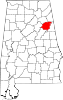
Eastaboga is located in the northern part of Talladega County on the border with Calhoun County. The city is located along U.S. Route 78 about 2 mi (3.2 km) north of Interstate 20, which runs west to east south of the community, with access from exit 173. Via I-20, Birmingham is 51 mi (82 km) west, and Atlanta is 100 mi (160 km) east. The largest city of over 20,000 people in the area is Anniston, which is east 13 mi (21 km) via I-20 or US 78.
Demographics
| Census | Pop. | Note | %± |
|---|---|---|---|
| 1900 | 820 | — | |
| U.S. Decennial Census[5] | |||
The present unincorporated community of Eastaboga was listed as the incorporated town of McFall on the 1900 census and had 820 residents. Of that, a majority, 482, lived on the Talladega County side, and 338 lived on the Calhoun County side. It was disincorporated after just 3 years in 1901 and the post office closed under that name in 1906.[6] At some point on, it was renamed Eastaboga (while the nearby community to the south of the same name became "Old Eastaboga").
Notable people
- Howie Camp, former Major League Baseball outfielder for the New York Yankees
- Johnny Ray, NASCAR driver
- Kevin Ray, NASCAR driver
See also
References
- ^ "Eastaboga ZIP Code". zipdatamaps.com. 2022. Retrieved November 11, 2022.
- ^ "Eastaboga". Geographic Names Information System. United States Geological Survey, United States Department of the Interior.
- ^ http://alabamamaps.ua.edu/historicalplaces/text/TalladegaText.pdf [bare URL PDF]
- ^ Gannett, Henry (1905). The Origin of Certain Place Names in the United States. Govt. Print. Off. pp. 121.
- ^ "U.S. Decennial Census". Census.gov. Archived from the original on April 26, 2015. Retrieved June 6, 2013.
- ^ http://alabamamaps.ua.edu/historicalplaces/text/TalladegaText.pdf [bare URL PDF]
- v
- t
- e
Municipalities and communities of Calhoun County, Alabama, United States
County seat: Anniston
communities
‡This populated place also has portions in an adjacent county or counties
- Alabama portal
- United States portal
Municipalities and communities of Talladega County, Alabama, United States | ||
|---|---|---|
County seat: Talladega | ||
| Cities | 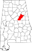 | |
| Towns | ||
| CDPs | ||
| Unincorporated communities | ||
| Ghost town | ||
| Footnotes | ‡This populated place also has portions in an adjacent county or counties | |
| ||
 | This Calhoun County, Alabama state location article is a stub. You can help Wikipedia by expanding it. |
- v
- t
- e


