Derna Province
Province of Libya under Italian rule

Darnah Province (called in Italian Provincia italiana di Derna) was one of the provinces of Libya under Italian rule. It was established in 1937 with the official name: "Commissariato Generale Provinciale di Derna". Derna province was called only "Darnah District" after World War II.
Characteristics
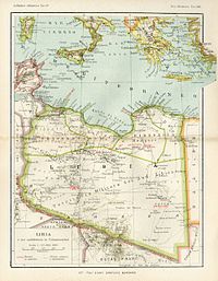
Derna province was located in northern Italian Libya, next to Egypt. It was a semi-arid area near the Mediterranean coast, with a fertile plateau around ancient Cyrene, but in the interior was the Sahara desert. Its administrative center was the small city of Derna on the Mediterranean coast.
It was divided in 3 "circondari" (sections):
- Derna
- Apollonia
- Tobruk
The province from 1939 was considered officially part of the Kingdom of Italy, with the same laws. It was one of the four new Italian provinces of the so-called Quarta Sponda (Fourth Shore). Indeed, on 9 January 1939, the colony of Italian Libya was incorporated into "metropolitan Italy" and thereafter considered an integral part of the Italian state itself (the French, in 1848, had incorporated French Algeria in the same manner).
In the coast of the province was built in 1937-1938 the eastern section of the Litoranea Balbia, that went from Tripoli to the border of Egypt. Some Italian colonists moved to live in a group of new villages after 1938: they increased local agricultural production, but British invasion during World War II destroyed all improvements.
The car tag for the Italian province of Derna was DE.[1]
Population in Province of Derna
According to the 1936 census, which allowed citizens to declare their ethnicity, Derna's native population was made up of 94.4% Arabs, 1.8% Turks, 0.7% Blacks, 0.2% Berbers, and 2.9% Others.[2]
According to the 1939 Italian Census of Libya,[3] these were the main population data:
| CITY | INHABITANTS | ITALIANS | NOTES |
|---|---|---|---|
| Beda Littoria | 16.238 pop. | 1.533 | Italians nearly 9,5% |
| Cyrene | 494 pop. | 222 | Italians nearly 45% |
| Bardia | 5,491 pop. | 216 | Italians nearly 4%; it was even called "Porto Bardia" |
| Derna | 16,609 pop. | 3,250 | Italians 20% |
| Tobruk | 11,284 pop. | 1,756 | Italians nearly 16% |
| Giarabub | 215 pop. | - | oasis with military garrison |
| Apollonia | 3,313 pop. | 449 | Italians 14% |
References
See also
- Tripoli Province
- Benghazi Province
- Misurata Province (Italian Libya)
- Military Territory of the South (Italian Libya)
- Italian Libya
- Fourth Shore
- Via Balbia
- v
- t
- e
- Italian settlers
- Italian Tripolitania
- Italian Cyrenaica
- Italian Empire
- Italian Libya Railways
- Railway stations in Libya
- Tripoli-Castel Benito Airport
- Italian Benghazi
- Via Balbia
- Via della Vittoria
- Arch of the Fileni
- Tripoli Grand Prix
- Tripoli International Fair
- Imperial Line
- Frontier Wire
- Italo-Turkish War
- Sciara Sciatt massacre
- Muslim Association of the Lictor
- Arab Lictor Youth
- Fort Capuzzo
- Auto-Saharan Company
- Fourth Shore
- Postage stamps
- Pidgin Italian of Libya
- Giovanni Innocenzo Martinelli
- Adriano Visconti
- Rossana Podestà
- Claudio Gentile
- Franco Califano
- Lorenzo Bandini
- Italian Libyan Colonial Division
- 1st Libyan Division
- 2nd Libyan Division
- Maletti Group
- Ascari del Cielo
- Italian African Police
- Bands
- Zaptié
- Savari
- Spahis
- Royal Corps of Colonial Troops
| ||||||||||||||
|---|---|---|---|---|---|---|---|---|---|---|---|---|---|---|
| Subdivisions |
|  | ||||||||||||
| Settlers and Irredentism |
| |||||||||||||
| Architecture |
| |||||||||||||
| Infrastructure | ||||||||||||||
| Political concepts | ||||||||||||||
| Police and military |
| |||||||||||||
| Currencies and Stamps | ||||||||||||||


