Deenish Island
51°44′13″N 10°13′13″W / 51.7370°N 10.2203°W / 51.7370; -10.2203
Ireland
Deenish Island (Irish: Duínis[1]) is an island of the Atlantic Ocean belonging to County Kerry, Ireland.
Geography
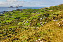
The island is 122 acres; its highest hill is at 144 m.[2] It's located in the Atlantic Ocean at around 1 km from Scariff Island[1] and 6.1 km from Hogs Head, on the mainland.[3]
History
In 1837 on Deenish (which at that time was called Dinish) resided three families who mainly lived on the cattle which grazed on the island.[4] 1911 census still reported six people living on the island.[1]
|
|
| ||||||||||||||||||||||||||||||||||||||||||||||||||||||||||||||||||||||||||||||
| Source: Central Statistics Office. "CNA17: Population by Off Shore Island, Sex and Year". CSO.ie. Retrieved 12 October 2016. | ||||||||||||||||||||||||||||||||||||||||||||||||||||||||||||||||||||||||||||||||
See also
 Ireland portal
 Islands portal


References
- ^ a b c "Duínis". St. Cronan's School. Retrieved 19 May 2015.
- ^ "Dunkerron Mountains Area - Deenish Island Hill". MountainViews. Ordnance Survey Ireland. Retrieved 19 May 2015.
- ^ "Traveling Luck for Hogs Head, Kerry, Ireland". travelingluck.com. Retrieved 26 May 2021.
- ^ Samuel Lewis (1837). A TOPOGRAPHICAL DICTIONARY OF IRELAND. S. LEWIS & Co. Retrieved 19 May 2015 – via libraryireland.com.
External links
![]() Media related to Deenish Island at Wikimedia Commons
Media related to Deenish Island at Wikimedia Commons
- Scariff and Deenish, page on irishislands.info
- The island page on iscoverireland.ie
- v
- t
- e
Places in County Kerry
County town: Tralee
- Ballybunion
- Cahersiveen
- Castleisland
- Dingle
- Kenmare
- Killorglin
- Killarney
- Listowel
- Tralee

Villages and
Townlands
- Abbeydorney
- Annascaul
- Ardfert
- Asdee
- Ballydavid
- Ballinskelligs
- Ballyduff
- Ballyferriter
- Ballyheigue
- Ballylongford
- Ballymacelligott
- Ballyseedy
- Blennerville
- Bonane
- Brandon Creek
- Brandon
- Brosna
- Caherboshina
- Caherdaniel
- Camp
- Castlecove
- Castlegregory
- Castlemaine
- Causeway
- Chapeltown
- Cloghane
- Coolgarriv
- Currans
- Currow
- Derrymore
- Derrynane
- Duagh
- Dunquin
- Doonshean
- Fahamore
- Farranfore
- Fenit
- Feothanach
- Fieries
- Finuge
- Fossa
- Glenbeigh
- Glenflesk
- Gneeveguilla
- Kilcummin
- Kilderry
- Kilflynn
- Kilgarvan
- Kilmoyley
- Knightstown
- Knockanure
- Knocknagoshel
- Lispole
- Lisselton
- Lixnaw
- Milltown
- Moyvane
- Portmagee
- Rathmore
- Scraggane
- Sneem
- Spa
- Tarbert
- Templenoe
- Tuosist
- Valentia Island
- Ventry
- Waterville
- Beginish
- Blasket Islands
- Deenish
- Fenit
- Innisfallen
- Magharee Islands
- Puffin
- Scariff
- Skellig Islands
- Valentia
- List of townlands in County Kerry
- Category:Geography of County Kerry


