Chaponost
Commune in Auvergne-Rhône-Alpes, France
Location of Chaponost

(2020–2026) Damien Combet[1]
1
(2021)[2]
69043 /69630
(avg. 325 m or 1,066 ft)
Chaponost (French pronunciation: [ʃapɔno]) is a commune in the Rhône department in eastern France.
It is known for its Roman aqueducts.
Monuments
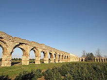

The Roman aqueduct of the Gier, estimated to be 75 km long, was built under Hadrian's reign during the second century CE to enable water supply of the Roman city of Lugdunum (Lyon) from Mont Pilat (source of the river Gier). Arches of the aqueducts (around 92 arches on 550 m) are located on the territory of the commune, at the site of "Le Plat de l'Air".
Population
| Year | Pop. | ±% p.a. |
|---|---|---|
| 1968 | 3,638 | — |
| 1975 | 4,632 | +3.51% |
| 1982 | 5,278 | +1.88% |
| 1990 | 6,911 | +3.43% |
| 1999 | 7,832 | +1.40% |
| 2007 | 7,972 | +0.22% |
| 2012 | 7,963 | −0.02% |
| 2017 | 8,717 | +1.83% |
| Source: INSEE[3] | ||
Twin towns
Chaponost is twinned with:
 Lesignano de' Bagni, Italy, since 2008

See also
References
- ^ "Répertoire national des élus: les maires" (in French). data.gouv.fr, Plateforme ouverte des données publiques françaises. 13 September 2022.
- ^ "Populations légales 2021". The National Institute of Statistics and Economic Studies. 28 December 2023.
- ^ Population en historique depuis 1968, INSEE
Wikimedia Commons has media related to Chaponost.
- v
- t
- e
Communes of the Rhône department 

- Affoux
- Aigueperse
- Alix
- Ambérieux
- Amplepuis
- Ampuis
- Ancy
- Anse
- L'Arbresle
- Les Ardillats
- Arnas
- Aveize
- Azolette
- Bagnols
- Beaujeu
- Beauvallon
- Belleville-en-Beaujolais
- Belmont-d'Azergues
- Bessenay
- Bibost
- Blacé
- Le Breuil
- Brignais
- Brindas
- Brullioles
- Brussieu
- Bully
- Cenves
- Cercié
- Chabanière
- Chambost-Allières
- Chambost-Longessaigne
- Chamelet
- La Chapelle-sur-Coise
- Chaponnay
- Chaponost
- Charentay
- Charnay
- Chasselay
- Châtillon
- Chaussan
- Chazay-d'Azergues
- Chénas
- Chénelette
- Les Chères
- Chessy
- Chevinay
- Chiroubles
- Civrieux-d'Azergues
- Claveisolles
- Cogny
- Coise
- Colombier-Saugnieu
- Communay
- Condrieu
- Corcelles-en-Beaujolais
- Cours
- Courzieu
- Cublize
- Denicé
- Deux-Grosnes
- Dième
- Dommartin
- Dracé
- Duerne
- Échalas
- Émeringes
- Éveux
- Fleurie
- Fleurieux-sur-l'Arbresle
- Frontenas
- Genas
- Gleizé
- Grandris
- Grézieu-la-Varenne
- Grézieu-le-Marché
- Les Haies
- Les Halles
- Haute-Rivoire
- Jons
- Joux
- Juliénas
- Jullié
- Lacenas
- Lachassagne
- Lamure-sur-Azergues
- Lancié
- Lantignié
- Larajasse
- Légny
- Lentilly
- Létra
- Limas
- Loire-sur-Rhône
- Longes
- Longessaigne
- Lozanne
- Lucenay
- Marchampt
- Marcilly-d'Azergues
- Marcy
- Marennes
- Meaux-la-Montagne
- Messimy
- Meys
- Millery
- Moiré
- Montagny
- Montmelas-Saint-Sorlin
- Montromant
- Montrottier
- Morancé
- Mornant
- Odenas
- Orliénas
- Le Perréon
- Pollionnay
- Pomeys
- Pommiers
- Porte des Pierres Dorées
- Poule-les-Écharmeaux
- Propières
- Pusignan
- Quincié-en-Beaujolais
- Ranchal
- Régnié-Durette
- Riverie
- Rivolet
- Ronno
- Rontalon
- Sain-Bel
- Saint-André-la-Côte
- Saint-Appolinaire
- Saint-Bonnet-de-Mure
- Saint-Bonnet-des-Bruyères
- Saint-Bonnet-le-Troncy
- Saint-Clément-de-Vers
- Saint-Clément-les-Places
- Saint-Clément-sur-Valsonne
- Saint-Cyr-le-Chatoux
- Saint-Cyr-sur-le-Rhône
- Saint-Didier-sur-Beaujeu
- Sainte-Catherine
- Sainte-Colombe
- Sainte-Consorce
- Sainte-Foy-l'Argentière
- Sainte-Paule
- Saint-Étienne-des-Oullières
- Saint-Étienne-la-Varenne
- Saint-Forgeux
- Saint-Genis-l'Argentière
- Saint-Georges-de-Reneins
- Saint-Germain-Nuelles
- Saint-Igny-de-Vers
- Saint-Jean-des-Vignes
- Saint-Jean-la-Bussière
- Saint-Julien
- Saint-Julien-sur-Bibost
- Saint-Just-d'Avray
- Saint-Lager
- Saint-Laurent-d'Agny
- Saint-Laurent-de-Chamousset
- Saint-Laurent-de-Mure
- Saint-Marcel-l'Éclairé
- Saint-Martin-en-Haut
- Saint-Nizier-d'Azergues
- Saint-Pierre-de-Chandieu
- Saint-Pierre-la-Palud
- Saint-Romain-de-Popey
- Saint-Romain-en-Gal
- Saint-Romain-en-Gier
- Saint-Symphorien-d'Ozon
- Saint-Symphorien-sur-Coise
- Saint-Vérand
- Saint-Vincent-de-Reins
- Salles-Arbuissonnas-en-Beaujolais
- Sarcey
- Les Sauvages
- Savigny
- Sérézin-du-Rhône
- Simandres
- Soucieu-en-Jarrest
- Sourcieux-les-Mines
- Souzy
- Taluyers
- Taponas
- Tarare
- Ternand
- Ternay
- Theizé
- Thizy-les-Bourgs
- Thurins
- Toussieu
- Trèves
- Tupin-et-Semons
- Val d'Oingt
- Valsonne
- Vaugneray
- Vaux-en-Beaujolais
- Vauxrenard
- Vernay
- Ville-sur-Jarnioux
- Villechenève
- Villefranche-sur-Saônesubpr
- Villié-Morgon
- Vindry-sur-Turdine
- Vourles
- Yzeron
- subpr: subprefecture
Authority control databases | |
|---|---|
| International |
|
| National |
|
 | This Rhône geographical article is a stub. You can help Wikipedia by expanding it. |
- v
- t
- e


