Carr Creek Lake
Reservoir in Knott County, Kentucky
37°14′06″N 83°00′11″W / 37.235°N 83.003°W / 37.235; -83.003Carr Creek Lake (formerly Carr Fork Lake), located east of Hazard, Kentucky, along Kentucky Route 15 in Knott County, is a 710 acres (3 km2) reservoir created by the U.S. Army Corps of Engineers in 1976.[2] Carr Creek Lake's earth and rock fill dam is 130 ft (40 m) tall and 720 ft (219 m) long, and the dam is located 8.8 mi (14 km) above the mouth of Carr Fork River, a tributary of the North Fork Kentucky River.[3]
The lake is the main attraction of Carr Creek State Park.[4]
-
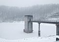 Control tower at Carr Creek Dam

References
- ^ U.S. Geological Survey Geographic Names Information System: Carr Creek Lake
- ^ Kleber, John E., ed. (1992). "Lakes". The Kentucky Encyclopedia. Associate editors: Thomas D. Clark, Lowell H. Harrison, and James C. Klotter. Lexington, Kentucky: The University Press of Kentucky. ISBN 0-8131-1772-0.
- ^ "Carr Creek Lake". U.S. Army Corps of Engineers. Retrieved 2007-02-17.
- ^ "Carr Creek State Park". Kentucky Department of Parks. 2005-10-10. Archived from the original on 2007-02-04. Retrieved 2007-02-17.
External links
- Recreation.gov - Carr Creek Lake
- Carr Creek State Park facilities map
- v
- t
- e
- Lake Barkley
- Barren River Lake
- Beaver Lake
- Boltz Lake
- Buckhorn Lake
- Bullock Pen Lake
- Lake Beshear
- Cannon Creek Lake
- Lake Carnico
- Carr Creek Lake
- Cave Run Lake
- Cedar Creek Lake
- Cranks Creek Lake
- Lake Cumberland
- Dale Hollow Lake
- Dewey Lake
- Doe Run Lake
- Elk Lake
- Elmer Davis Lake
- Fishtrap Lake
- Grayson Lake
- Green River Lake
- Greenbo Lake
- Guist Creek Lake
- Herrington Lake
- Kentucky Lake
- Kincaid Lake
- Laurel River Lake
- Lake Linville
- Lake Malone
- Martins Fork Lake
- Nolin River Lake
- Paintsville Lake
- Pan Bowl Lake
- Rough River Lake
- Shanty Hollow Lake
- Shelby Lake
- Swan Lake
- Taylorsville Lake
- Wilgreen Lake
- Williamstown Lake
- Willisburg Lake
- Wood Creek Lake
- Yatesville Lake

 Kentucky portal •
  Lakes portal


 | This Knott County, Kentucky state location article is a stub. You can help Wikipedia by expanding it. |
- v
- t
- e
This article related to a protected area in Kentucky is a stub. You can help Wikipedia by expanding it. |
- v
- t
- e


