Bréal-sous-Montfort
Commune in Brittany, France
Bréal-sous-Montfort Beréau (Gallo) Breal-Moñforzh (Breton) | ||
|---|---|---|
Commune | ||
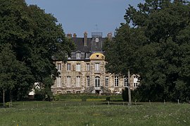 Château du Molant | ||
 Coat of arms | ||
Location of Bréal-sous-Montfort  | ||
(2020–2026) Bernard Éthoré[1] | | |
| Area 1 | 33.82 km2 (13.06 sq mi) | |
| Population (2021)[2] | 6,469 | |
| • Density | 190/km2 (500/sq mi) | |
| Time zone | UTC+01:00 (CET) | |
| • Summer (DST) | UTC+02:00 (CEST) | |
| INSEE/Postal code | 35037 /35310 | |
| Elevation | 19–82 m (62–269 ft) | |
| 1 French Land Register data, which excludes lakes, ponds, glaciers > 1 km2 (0.386 sq mi or 247 acres) and river estuaries. | ||
Bréal-sous-Montfort (French pronunciation: [bʁeal su mɔ̃fɔʁ], literally Bréal under Montfort; Gallo: Beréau, Breton: Breal-Moñforzh) is a commune in the Ille-et-Vilaine department in the region in Brittany in northwestern France.
It is located in the outer southwest district of Rennes, near the Broceliand woods.
Geography
The Meu forms the commune's northeastern border.
Population
Inhabitants of Bréal-sous-Montfort are called Bréalais in French.
| Year | Pop. | ±% p.a. |
|---|---|---|
| 1968 | 1,771 | — |
| 1975 | 2,518 | +5.16% |
| 1982 | 3,117 | +3.10% |
| 1990 | 3,399 | +1.09% |
| 1999 | 3,825 | +1.32% |
| 2007 | 4,577 | +2.27% |
| 2012 | 5,216 | +2.65% |
| 2017 | 6,131 | +3.29% |
| Source: INSEE[3] | ||
See also
References
- ^ "Répertoire national des élus: les maires". data.gouv.fr, Plateforme ouverte des données publiques françaises (in French). 2 December 2020.
- ^ "Populations légales 2021". The National Institute of Statistics and Economic Studies. 28 December 2023.
- ^ Population en historique depuis 1968, INSEE
External links
Wikimedia Commons has media related to Bréal-sous-Montfort.
- Official website (in French)
- Base Mérimée: Search for heritage in the commune, Ministère français de la Culture. (in French)
- Cultural Heritage (in French)
- Mayors of Ille-et-Vilaine Association Archived 14 January 2012 at the Wayback Machine (in French)
- v
- t
- e

- Acigné
- Amanlis
- Andouillé-Neuville
- Arbrissel
- Argentré-du-Plessis
- Aubigné
- Availles-sur-Seiche
- Baguer-Morvan
- Baguer-Pican
- Bain-de-Bretagne
- Bains-sur-Oust
- Bais
- Balazé
- Baulon
- La Baussaine
- La Bazouge-du-Désert
- Bazouges-la-Pérouse
- Beaucé
- Bécherel
- Bédée
- Betton
- Billé
- Bléruais
- Boisgervilly
- Boistrudan
- Bonnemain
- La Bosse-de-Bretagne
- La Bouëxière
- Bourgbarré
- Bourg-des-Comptes
- La Boussac
- Bovel
- Bréal-sous-Montfort
- Bréal-sous-Vitré
- Brécé
- Breteil
- Brie
- Brielles
- Broualan
- Bruc-sur-Aff
- Les Brulais
- Bruz
- Cancale
- Cardroc
- Cesson-Sévigné
- Champeaux
- Chanteloup
- Chantepie
- La Chapelle-aux-Filtzméens
- La Chapelle-Bouëxic
- La Chapelle-Chaussée
- La Chapelle-de-Brain
- La Chapelle-des-Fougeretz
- La Chapelle-du-Lou-du-Lac
- La Chapelle-Erbrée
- La Chapelle-Fleurigné
- La Chapelle-Saint-Aubert
- La Chapelle-Thouarault
- Chartres-de-Bretagne
- Chasné-sur-Illet
- Châteaubourg
- Châteaugiron
- Châteauneuf-d'Ille-et-Vilaine
- Le Châtellier
- Châtillon-en-Vendelais
- Chauvigné
- Chavagne
- Chelun
- Cherrueix
- Chevaigné
- Cintré
- Clayes
- Coësmes
- Comblessac
- Combourg
- Combourtillé
- Cornillé
- Corps-Nuds
- La Couyère
- Crevin
- Le Crouais
- Cuguen
- Dinard
- Dingé
- Dol-de-Bretagne
- Domagné
- Domalain
- La Dominelais
- Domloup
- Dourdain
- Drouges
- Eancé
- Epiniac
- Erbrée
- Ercé-en-Lamée
- Ercé-près-Liffré
- Essé
- Étrelles
- Feins
- Le Ferré
- Forges-la-Forêt
- Fougèressubpr
- La Fresnais
- Gaël
- Gahard
- Gennes-sur-Seiche
- Gévezé
- Gosné
- La Gouesnière
- Goven
- Grand-Fougeray
- La Guerche-de-Bretagne
- Guichen
- Guignen
- Guipel
- Guipry-Messac
- Hédé-Bazouges
- L'Hermitage
- Hirel
- Iffendic
- Les Iffs
- Irodouër
- Janzé
- Javené
- Laignelet
- Laillé
- Lalleu
- Landavran
- Landéan
- Landujan
- Langan
- Langon
- Langouet
- Lanrigan
- Lassy
- Lécousse
- Lieuron
- Liffré
- Lillemer
- Livré-sur-Changeon
- Lohéac
- Longaulnay
- Le Loroux
- Lourmais
- Loutehel
- Louvigné-de-Bais
- Louvigné-du-Désert
- Luitré-Dompierre
- Maen Roch
- Marcillé-Raoul
- Marcillé-Robert
- Marpiré
- Martigné-Ferchaud
- Maxent
- Mecé
- Médréac
- Meillac
- Melesse
- Mellé
- Mernel
- Mesnil-Roc'h
- La Mézière
- Mézières-sur-Couesnon
- Miniac-Morvan
- Miniac-sous-Bécherel
- Le Minihic-sur-Rance
- Mondevert
- Montauban-de-Bretagne
- Montautour
- Mont-Dol
- Monterfil
- Montfort-sur-Meu
- Montgermont
- Monthault
- Montreuil-des-Landes
- Montreuil-le-Gast
- Montreuil-sous-Pérouse
- Montreuil-sur-Ille
- Mordelles
- Mouazé
- Moulins
- Moussé
- Moutiers
- Muel
- La Noë-Blanche
- La Nouaye
- Nouvoitou
- Noyal-Châtillon-sur-Seiche
- Noyal-sous-Bazouges
- Noyal-sur-Vilaine
- Orgères
- Pacé
- Paimpont
- Pancé
- Parcé
- Parigné
- Parthenay-de-Bretagne
- Le Pertre
- Le Petit-Fougeray
- Pipriac
- Piré-Chancé
- Pléchâtel
- Pleine-Fougères
- Plélan-le-Grand
- Plerguer
- Plesder
- Pleugueneuc
- Pleumeleuc
- Pleurtuit
- Pocé-les-Bois
- Poilley
- Poligné
- Pont-Péan
- Les Portes du Coglais
- Princé
- Québriac
- Quédillac
- Rannée
- Redonsubpr
- Renac
- Rennespref
- Retiers
- Le Rheu
- La Richardais
- Rimou
- Rives-du-Couesnon
- Romagné
- Romazy
- Romillé
- Roz-Landrieux
- Roz-sur-Couesnon
- Sains
- Saint-Armel
- Saint-Aubin-d'Aubigné
- Saint-Aubin-des-Landes
- Saint-Aubin-du-Cormier
- Saint-Benoît-des-Ondes
- Saint-Briac-sur-Mer
- Saint-Brieuc-des-Iffs
- Saint-Broladre
- Saint-Christophe-des-Bois
- Saint-Christophe-de-Valains
- Saint-Coulomb
- Saint-Didier
- Saint-Domineuc
- Sainte-Anne-sur-Vilaine
- Sainte-Colombe
- Sainte-Marie
- Saint-Erblon
- Saint-Ganton
- Saint-Georges-de-Gréhaigne
- Saint-Georges-de-Reintembault
- Saint-Germain-du-Pinel
- Saint-Germain-en-Coglès
- Saint-Germain-sur-Ille
- Saint-Gilles
- Saint-Gondran
- Saint-Gonlay
- Saint-Grégoire
- Saint-Guinoux
- Saint-Hilaire-des-Landes
- Saint-Jacques-de-la-Lande
- Saint-Jean-sur-Vilaine
- Saint-Jouan-des-Guérets
- Saint-Just
- Saint-Léger-des-Prés
- Saint-Lunaire
- Saint-Malosubpr
- Saint-Malo-de-Phily
- Saint-Malon-sur-Mel
- Saint-Marcan
- Saint-Marc-le-Blanc
- Saint-Maugan
- Saint-Médard-sur-Ille
- Saint-Méen-le-Grand
- Saint-Méloir-des-Ondes
- Saint-M'Hervé
- Saint-Onen-la-Chapelle
- Saint-Ouen-des-Alleux
- Saint-Péran
- Saint-Père-Marc-en-Poulet
- Saint-Pern
- Saint-Rémy-du-Plain
- Saint-Sauveur-des-Landes
- Saint-Séglin
- Saint-Senoux
- Saint-Suliac
- Saint-Sulpice-des-Landes
- Saint-Sulpice-la-Forêt
- Saint-Symphorien
- Saint-Thual
- Saint-Thurial
- Saint-Uniac
- Saulnières
- Le Sel-de-Bretagne
- La Selle-en-Luitré
- La Selle-Guerchaise
- Sens-de-Bretagne
- Servon-sur-Vilaine
- Sixt-sur-Aff
- Sougeal
- Taillis
- Talensac
- Teillay
- Le Theil-de-Bretagne
- Thorigné-Fouillard
- Thourie
- Le Tiercent
- Tinténiac
- Torcé
- Trans-la-Forêt
- Treffendel
- Trémeheuc
- Tresbœuf
- Trévérien
- Trimer
- Le Tronchet
- Val-Couesnon
- Val d'Anast
- Val-d'Izé
- Vergéal
- Le Verger
- Vern-sur-Seiche
- Vezin-le-Coquet
- Vieux-Viel
- Vieux-Vy-sur-Couesnon
- Vignoc
- Villamée
- La Ville-ès-Nonais
- Visseiche
- Vitré
- Le Vivier-sur-Mer
- pref: prefecture
- subpr: subprefecture
| Authority control databases: National |
|
|---|
 | This Ille-et-Vilaine geographical article is a stub. You can help Wikipedia by expanding it. |
- v
- t
- e


