Borutta
Comune in Sardinia, Italy
Borutta Boruta | |
|---|---|
Comune | |
| Comune di Borutta | |
 | |
 Coat of arms | |
Location of Borutta  | |
40°31′N 8°45′E / 40.517°N 8.750°E / 40.517; 8.750 | |
| Country | Italy |
| Region | Sardinia |
| Province | Sassari (SS) |
| Government | |
| • Mayor | Silvano Quirico Salvatore Arru |
| Area | |
| • Total | 4.8 km2 (1.9 sq mi) |
| Elevation | 491 m (1,611 ft) |
| Population (30 June 2017)[2] | |
| • Total | 284 |
| • Density | 59/km2 (150/sq mi) |
| Time zone | UTC+1 (CET) |
| • Summer (DST) | UTC+2 (CEST) |
| Postal code | 07040 |
| Dialing code | 079 |
| Website | Official website |
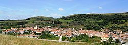
Borutta (Sardinian: Boruta) is a comune (municipality) in the Province of Sassari in the Italian region Sardinia, located about 150 kilometres (93 mi) north of Cagliari and about 30 kilometres (19 mi) southeast of Sassari.
Borutta borders the following municipalities: Bessude, Bonnanaro, Cheremule, Thiesi, Torralba. The volcanic hill once housing the village of Sorres (destroyed by the Aragonese in the early 14th century) houses the Pisan-Romanesque church of San Pietro di Sorres.

References
Wikimedia Commons has media related to Borutta.
- v
- t
- e
- Aggius
- Aglientu
- Alà dei Sardi
- Alghero
- Anela
- Ardara
- Arzachena
- Badesi
- Banari
- Benetutti
- Berchidda
- Bessude
- Bonnanaro
- Bono
- Bonorva
- Bortigiadas
- Borutta
- Bottidda
- Buddusò
- Budoni
- Bultei
- Bulzi
- Burgos
- Calangianus
- Cargeghe
- Castelsardo
- Cheremule
- Chiaramonti
- Codrongianos
- Cossoine
- Erula
- Esporlatu
- Florinas
- Giave
- Golfo Aranci
- Illorai
- Ittireddu
- Ittiri
- La Maddalena
- Laerru
- Loiri Porto San Paolo
- Luogosanto
- Luras
- Mara
- Martis
- Monteleone Rocca Doria
- Monti
- Mores
- Muros
- Nughedu San Nicolò
- Nule
- Nulvi
- Olbia
- Olmedo
- Oschiri
- Osilo
- Ossi
- Ozieri
- Padria
- Padru
- Palau
- Pattada
- Perfugas
- Ploaghe
- Porto Torres
- Pozzomaggiore
- Putifigari
- Romana
- San Teodoro
- Santa Maria Coghinas
- Santa Teresa Gallura
- Sant'Antonio di Gallura
- Sassari
- Sedini
- Semestene
- Sennori
- Siligo
- Sorso
- Stintino
- Telti
- Tempio Pausania
- Tergu
- Thiesi
- Tissi
- Torralba
- Trinità d'Agultu e Vignola
- Tula
- Uri
- Usini
- Valledoria
- Viddalba
- Villanova Monteleone

| Authority control databases |
|
|---|
 | This Sardinia location article is a stub. You can help Wikipedia by expanding it. |
- v
- t
- e


