Bönen
Municipality in North Rhine-Westphalia, Germany

Coat of arms
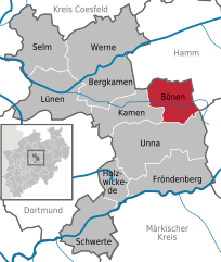
Location of Bönen within Unna district
(2020–25) Stephan Rotering[1]
(2022-12-31)[2]
59199
Bönen (German pronunciation: [ˈbøːnən]) is a municipality in the district of Unna, in North Rhine-Westphalia, Germany. It is situated between Hamm in the north-east, Kamen in the west and Unna in the south. Bönen consists of the districts Altenbögge-Bönen, Bramey-Lenningsen, Flierich, Nordbögge, Osterbönen and Westerbönen.
Education
Bönen has two primary schools, Hellwegschule and Goetheschule, and three secondary schools, Pestalozzi-Hauptschule, Humboldt-Realschule and Marie-Curie-Gymnasium. The family friendly environment and good education offerings attract increasing numbers of young families to Bönen.[citation needed]
Pestalozzi-Hauptschule
The Pestalozzi-Hauptschule was founded in 1890 and received a quality certificate in 2009. The school has a partnership with Deutsche Bahn to inform children of job opportunities and support them in pursuing their careers.
Humboldt-Realschule
This school has the longest history among the schools in Bönen, as it was founded in 1840. It has a broad offering of afternoon activities like sports and music.
Marie-Curie-Gymnasium
Marie-Curie-Gymnasium was founded in 1999 and started off with two teachers and 66 pupils. 2008 this first year celebrated its Abitur. It has an excellent reputation[citation needed] and even attracts pupils from the neighbour cities Unna and Hamm.[citation needed]
Notable people
- Stefan Heinig (born 1962), CEO of Kik
- Joshua Filler (born 1997), Professional Pool Player
Gallery
-
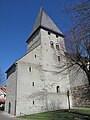 Church: die Alte Kirche
 -
 Church: die Christ König Kirche
 -
 Monumental house: Bahnhofstrasse 151
 -
 Gasthof at the Bahnhofstrasse


References
- ^ Wahlergebnisse in NRW Kommunalwahlen 2020, Land Nordrhein-Westfalen, accessed 30 June 2021.
- ^ "Bevölkerung der Gemeinden Nordrhein-Westfalens am 31. Dezember 2022 – Fortschreibung des Bevölkerungsstandes auf Basis des Zensus vom 9. Mai 2011" (in German). Landesbetrieb Information und Technik NRW. Retrieved 20 June 2023.
Wikimedia Commons has media related to Bönen.
- v
- t
- e
Towns and municipalities in Unna (district)

Authority control databases | |
|---|---|
| International |
|
| National |
|
| Geographic |
|
| This Unna district location article is a stub. You can help Wikipedia by expanding it. |
- v
- t
- e


