Antoing
Municipality in French Community, Belgium
Antoing Antweon (Picard) | |
|---|---|
Municipality | |
 | |
 Flag  Coat of arms | |
Location of Antoing  | |
  Antoing Location in Belgium  | |
| Coordinates: 50°34′N 03°27′E / 50.567°N 3.450°E / 50.567; 3.450 | |
| Country |  Belgium Belgium |
| Community | French Community |
| Region | Wallonia |
| Province | Hainaut |
| Arrondissement | Tournai |
| Government | |
| • Mayor | Bernard Bauwens |
| Area | |
| • Total | 31.33 km2 (12.10 sq mi) |
| Population (2018-01-01)[1] | |
| • Total | 7,760 |
| • Density | 250/km2 (640/sq mi) |
| Postal codes | 7640-7643 |
| NIS code | 57003 |
| Area codes | 069 |
Antoing (French pronunciation: [ɑ̃twɛ̃] ⓘ; Picard: Antweon) is a city and municipality of Wallonia located in the province of Hainaut, Belgium.
The municipality consists of the following districts: Antoing, Bruyelle, Calonne, Fontenoy, Maubray, and Péronnes-lez-Antoing.
History
The Battle of Fontenoy, a major battle in the War of Austrian Succession, was fought near Fontenoy village on 11 May 1745.
Places of interest
- Antoing Castle, originally from the 12th century, restored by Eugène Viollet-le-Duc in the 19th century[2]
-
 Antoing Castle, castle of the Princes de Ligne (13th - 16th centuries)
 -
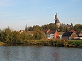
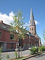 Churchtower (l'église Saint-Pierre)
 -
 Calonne, industrial area along the Scheldt


Famous inhabitants
- Raoul Cauvin, comics writer, was born in Antoing in 1938
References
External links
 Media related to Antoing at Wikimedia Commons
Places adjacent to Antoing | ||||||||||||||||
|---|---|---|---|---|---|---|---|---|---|---|---|---|---|---|---|---|
| ||||||||||||||||


- v
- t
- e

- Bold indicates cities
- Italic indicates municipalities with language facilities
Authority control databases | |
|---|---|
| International |
|
| National |
|
| Geographic |
|
 | This Hainaut Province location article is a stub. You can help Wikipedia by expanding it. |
- v
- t
- e


