Antioch Township, Hot Spring County, Arkansas
Township in Arkansas, United States
Township in Arkansas, United States
34°18′31″N 92°59′33″W / 34.308717°N 92.992549°W / 34.308717; -92.992549[1] (2010)[1]
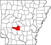
Antioch Township is a township in Hot Spring County, Arkansas, United States.[4] Its total population was 432 as of the 2010 United States Census,[1][5] an increase of 12.21 percent from 385 at the 2000 census.[6][7]

According to the 2010 Census, Antioch Township is located at 34°18′31″N 92°59′33″W / 34.308717°N 92.992549°W / 34.308717; -92.992549 (34.308717, -92.992549).[1] It has a total area of 14.310 square miles (37.06 square kilometers), all of which is land.[1] As per the USGS National Elevation Dataset, the elevation is 446 feet (136 m).[2]
References
- ^ a b c d e f "County Subdivisions (2010): Arkansas". 2010 Census Gazetteer Files. United States Census Bureau. Archived from the original (TXT) on May 31, 2014. Retrieved May 31, 2014.
- ^ a b c d "Feature ID 66651: Township of Antioch (Hot Spring County, Arkansas)". Geographic Names Information System. United States Geological Survey. Retrieved May 31, 2014.
- ^ a b "FIPS55 Data: Arkansas". FIPS55 Data. United States Geological Survey. February 23, 2006. Archived from the original (TXT) on June 18, 2006. Retrieved May 31, 2014.
- ^ "Summary Population and Housing Characteristics, CPH-1-5, Arkansas" (PDF). 2010 Census of Population and Housing. United States Census Bureau. September 2012. Retrieved May 31, 2014.
- ^ "2010 Demographic Profile (DP-1): Antioch township, Hot Spring County, Arkansas". American FactFinder. United States Census Bureau. Archived from the original on February 12, 2020. Retrieved May 31, 2014.
- ^ "2000 Demographic Profile (DP-1): Antioch township, Hot Spring County, Arkansas". American FactFinder. United States Census Bureau. Archived from the original on February 12, 2020. Retrieved May 31, 2014.
- ^ "County Subdivisions (2000)". 2000 Census Gazetteer Files. United States Census Bureau. Archived from the original (Zipped TXT) on May 31, 2014. Retrieved May 31, 2014.
External links
- "2010 Census Block Map: Antioch Township, Arkansas" (PDF). Arkansas 2010 Census Block Maps - County Subdivisions. U.S. Census Bureau.
- "2013 Boundary and Annexation Survey (BAS) Map: Hot Spring County, Arkansas" (PDF). Boundary and Annexation Survey (BAS) Shapefiles and Maps. U.S. Census Bureau. Archived from the original (PDF) on March 4, 2016. Retrieved May 31, 2014.
- "2010 Census County Subdivision Maps: Arkansas" (PDF). County Subdivision Maps. U.S. Census Bureau.
- v
- t
- e
Municipalities and communities of Hot Spring County, Arkansas, United States
County seat: Malvern
- Antioch
- Big Creek
- Bismarck
- Brown Springs
- Butterfield
- Clear Creek
- De Roche
- Dover
- Fenter
- Gifford
- Harrison
- Henderson
- Lone Hill
- Magnet
- Midway
- Montgomery
- Ouachita
- Prairie
- Saline
- Valley
communities
- Arkansas portal
- United States portal
 | This article about a location in Hot Spring County, Arkansas is a stub. You can help Wikipedia by expanding it. |
- v
- t
- e


