Liste der Einträge im National Register of Historic Places im Peoria County

Die Liste der Einträge im National Register of Historic Places im Peoria County in Illinois führt alle Bauwerke und historischen Stätten im Peoria County auf, die in das National Register of Historic Places aufgenommen wurden.[1]
Legende
| NRHP | Historic Place |
|---|---|
| HD | Historic District |
Aktuelle Einträge
| [2] | Name[3] | Bild | Eintragsdatum | Lage | Ort | Beschreibung |
|---|---|---|---|---|---|---|
| 1 | Central National Bank Building |  | 1978 ID-Nr. 78003450 | 103 SW Adams Street 40° 41′ 27″ N, 89° 35′ 20″ W40.690833-89.588889 | Peoria | |
| 2 | Christ Church of Lower Kickapoo |  | 1983 ID-Nr. 83000333 | Westlich von Norwood an der Christ Church Road 40° 42′ 25″ N, 89° 43′ 0″ W40.706944-89.716667 | Norwood | |
| 3 | Cumberland Presbyterian Church | 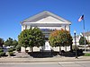 | 1980 ID-Nr. 80001401 | 405 North Monson Street 40° 41′ 33″ N, 89° 35′ 46″ W40.6925-89.596111 | Peoria | |
| 4 | Judge Flanagan Residence |  | 1975 ID-Nr. 75000670 | 942 NE Glen Oak Avenue 40° 42′ 14″ N, 89° 35′ 7″ W40.703889-89.585278 | Peoria | |
| 5 | Judge Jacob Gale House |  | 1982 ID-Nr. 82002591 | 403 NE Jefferson Street 40° 41′ 46″ N, 89° 35′ 8″ W40.696111-89.585556 | Peoria | |
| 6 | Grand Army of the Republic Memorial Hall | 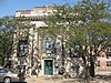 | 1976 ID-Nr. 76000723 | 416 Hamilton Boulevard 40° 41′ 40″ N, 89° 35′ 21″ W40.694444-89.589167 | Peoria | |
| 7 | Grand View Drive | 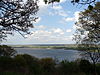 | 1996 ID-Nr. 96000399 | Abgegrenzt durch North Prospect Road, Illinois River, Adams Street und Grand View Drive 40° 44′ 30″ N, 89° 33′ 52″ W40.741667-89.564444 | Peoria und Peoria Heights | |
| 8 | Illinois Waterway Project Office |  | 2004 ID-Nr. 04000168 | 257 Grant Street 40° 44′ 20,2″ N, 89° 34′ 32,4″ W40.738933-89.575653 | Peoria | |
| 9 | International Harvester Building |  | 2005 ID-Nr. 05001254 | 1301-1309 Southwest Washington Street 40° 40′ 53″ N, 89° 36′ 14″ W40.681389-89.603889 | Peoria | |
| 10 | Jubilee College | 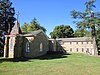 | 1972 ID-Nr. 72000465 | Nordwestlich von Kickapoo am US 150 40° 49′ 38″ N, 89° 46′ 40″ W40.827222-89.777778 | Kickapoo | |
| 11 | Madison Theatre | 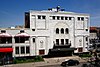 | 1980 ID-Nr. 80001402 | 502 Main Street 40° 41′ 39″ N, 89° 35′ 29″ W40.694167-89.591389 | Peoria | |
| 12 | North Side Historic District |  | 1983 ID-Nr. 83003588 | Abgegrenzt durch Perry Street, Caroline Street, Madison Street und Fayette Street 40° 41′ 57″ N, 89° 35′ 2″ W40.699167-89.583889 | Peoria | |
| 13 | Peace and Harvest |  | 1994 ID-Nr. 87002527 | Jefferson Street und Hamilton Street 40° 41′ 35″ N, 89° 35′ 21″ W40.693056-89.589167 | Peoria | |
| 14 | Peoria Automobile Club | 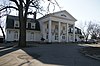 | 1995 ID-Nr. 95000984 | 100 Park Boulevard 40° 54′ 12″ N, 89° 29′ 24″ W40.903333-89.49 | Chillicothe | |
| 15 | Peoria City Hall |  | 1973 ID-Nr. 73000715 | 419 Fulton Street 40° 41′ 32″ N, 89° 35′ 33″ W40.692222-89.5925 | Peoria | |
| 16 | Peoria Cordage Company |  | 1982 ID-Nr. 82002592 | 1506 Southwest Washington Street 40° 40′ 47″ N, 89° 36′ 19″ W40.67972-89.60527 | Peoria | |
| 17 | Peoria Mineral Springs |  | 1982 ID-Nr. 82002593 | 701 West 7th Avenue 40° 41′ 45″ N, 89° 36′ 18″ W40.695833-89.605 | Peoria | |
| 18 | Peoria State Hospital |  | 1982 ID-Nr. 82002590 | Ricketts Avenue nahe dem US 24 40° 38′ 4″ N, 89° 39′ 32″ W40.634444-89.658889 | Bartonville | |
| 19 | Peoria Waterworks |  | 1980 ID-Nr. 80001403 | Lorentz Avenue 40° 43′ 28″ N, 89° 33′ 8″ W40.724444-89.552222 | Peoria | |
| 20 | Pere Marquette Hotel |  | 1982 ID-Nr. 82002594 | 501 Main Street 40° 41′ 37″ N, 89° 35′ 31″ W40.693611-89.591944 | Peoria | |
| 21 | Pettingill-Morron House |  | 1976 ID-Nr. 76000724 | 1212 West Moss Avenue 40° 41′ 39″ N, 89° 36′ 41″ W40.694167-89.611389 | Peoria | |
| 22 | The Pioneers |  | 2001 ID-Nr. 01000117 | Central Park, nördlich der Magnolia Street 40° 46′ 45″ N, 89° 58′ 22″ W40.779167-89.972778 | Elmwood | |
| 23 | Pleasant Grove School |  | 1994 ID-Nr. 94000435 | Pleasant Grove Road, rund 10 km westlich der Eden Road 40° 40′ 41″ N, 89° 50′ 43″ W40.678056-89.845278 | Eden | |
| 24 | John C. Proctor Recreation Center | 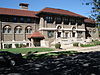 | 1979 ID-Nr. 79000860 | 300 South Allen Street 40° 41′ 7″ N, 89° 36′ 58″ W40.685278-89.616111 | Peoria | |
| 25 | Rock Island Depot and Freight House |  | 1978 ID-Nr. 78001180 | 32 Liberty Street 40° 41′ 17″ N, 89° 35′ 20″ W40.688056-89.588889 | Peoria | |
| 26 | Springdale Cemetery | 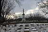 | 2004 ID-Nr. 04001303 | 3014 North Prospect Road 40° 43′ 24,4″ N, 89° 34′ 30,3″ W40.723445-89.575076 | Peoria | |
| 27 | U.S. Post Office and Courthouse |  | 2012 ID-Nr. 12000878 | 100 Northeast Monroe Street 40° 41′ 41,6″ N, 89° 35′ 30,2″ W40.69489-89.591733 | Peoria | |
| 28 | Washington C. Wear House | 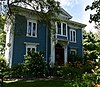 | 1993 ID-Nr. 93000838 | Rund 1 Meile südlich und 0,4 Meilen westlich der Kreuzung von IL 90 und IL 91 40° 54′ 55″ N, 89° 45′ 53″ W40.915278-89.764722 | Princeville | |
| 29 | West Bluff Historic District |  | 1976 ID-Nr. 76000725 | Randolph Street, High Street und Moss Street, östlich der Western Street 40° 41′ 49″ N, 89° 36′ 31″ W40.696944-89.608611 | Peoria | |
| 30 | YWCA Building |  | 2007 ID-Nr. 07000147 | 301 Northeast Jefferson Street 40° 41′ 40″ N, 89° 35′ 16″ W40.694444-89.587778 | Peoria |
Siehe auch
Einzelnachweise
- ↑ Auszug aus dem National Register of Historic Places - Peoria County Abgerufen am 18. Januar 2013
- ↑ Die Nummerierung in dieser Listenspalte ist an der vom National Park Service vorgelegten Reihenfolge der Einträge orientiert; die Farben unterscheiden verschiedene Schutzgebietstypen des Nationalparksystems mit landesweiter Bedeutung (z. B. National Historic Landmarks) von den sonstigen Einträgen im National Register of Historic Places.
- ↑ National Register Information System. In: National Register of Historic Places. National Park Service, abgerufen am 9. Juli 2010 (englisch).

Einträge im National Register of Historic Places in Illinois
National Register of Historic Places in Illinois
Adams | Alexander | Bond | Boone | Brown | Bureau | Calhoun | Carroll | Cass | Champaign | Christian | Clark | Clay | Clinton | Coles | Cook (inkl. Chicago) | Crawford | Cumberland | DeKalb | DeWitt | Douglas | DuPage | Edgar | Edwards | Effingham | Fayette | Ford | Franklin | Fulton | Gallatin | Greene | Grundy | Hamilton | Hancock | Hardin | Henderson | Henry | Iroquois | Jackson | Jasper | Jefferson | Jersey | Jo Daviess | Johnson | Kane | Kankakee | Kendall | Knox | LaSalle | Lake | Lawrence | Lee | Livingston | Logan | Macon | Macoupin | Madison | Marion | Marshall | Mason | Massac | McDonough | McHenry | McLean | Menard | Mercer | Monroe | Montgomery | Morgan | Moultrie | Ogle | Peoria | Perry | Piatt | Pike | Pope | Pulaski | Putnam | Randolph | Richland | Rock Island | Saline | Sangamon | Schuyler | Scott | Shelby | St. Clair | Stark | Stephenson | Tazewell | Union | Vermilion | Wabash | Warren | Washington | Wayne | White | Whiteside | Will | Williamson | Winnebago | Woodford


